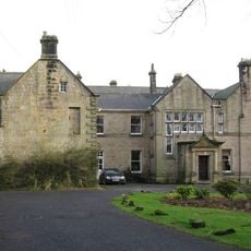
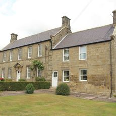
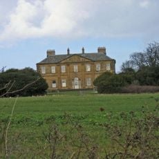
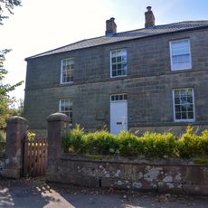
Swarland Old Hall, Grade II* listed country house in Newton-on-the-Moor and Swarland, England.
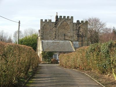
Swarland Old Hall is a country house with a four-bay south front, two storeys, and attics. Its east side features an unusual full-height screen wall with three blind Gothic arches.
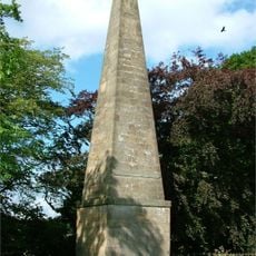
The estate belonged to the de Haslerigg family from early times until the 18th century. William Haslerigg died in 1681 and was honored with a railed monument near the house.
The hall shows how English country houses evolved, blending elements from older structures while keeping its 17th-century character. Its design reflects how wealthy families shaped and adapted their homes over time.
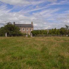
The house sits in a rural setting, roughly 11 kilometers south of Alnwick. The best time to visit is during warmer months when access points are dry and pathways are easier to walk.
The Gothic screen wall on the east side is unusually tall and broken by three inserted arches, an architectural feature rarely seen on other houses of this era. This curious detail suggests the wall's original purpose may have been different from what its present appearance suggests.
Location: Newton-on-the-Moor and Swarland
GPS coordinates: 55.31120,-1.74984
Latest update: December 14, 2025 18:05
Nelson Memorial
1.8 km
Embleton Hall
3 km
Church of St Michael and All Angels, Felton
2.8 km
Devil's Causeway
3.8 km
Church of St Mary
3 km
Guyzance (or Brainshaugh) Chapel near Acklington
5 km
Pant On North Of Junction With Church Street
3 km
The Anglers Arms
4 km
Rookwood House And Adjacent Cottage
3.3 km
Weldon Bridge, Over River Coquet And Wall To North-west
4.1 km
Milepost Opposite Besom Barn Restaurant
3.6 km
Milepost Opposite Sunnyside
4.6 km
Felton War Memorial
3 km
Old Felton Bridge
3 km
Milepost 180 Metres North Of Framlington Gate
4.5 km
Milepost Opposite Peth Foot
3 km
Park Lodge
2.9 km
Milepost 100 Metres South Of Rashercap
1.9 km
Acton House And House At Rear
3.2 km
Newmoor Hall
2.2 km
Brinkheugh Farmhouse And Outbuilding To East
5.2 km
Milepost On East Side Of Old Road Down To Weldon Bridge (Q.V.)
4.2 km
Pill Box At Nz 126 982
5 km
4 Boundary Stones On Boundary With Longframlington Civil Parish
5.4 km
Lishman House
3 km
Pair Of Stones On Cartington Longframlington Parish Boundary
5.1 km
Milepost Approximately 25 Metres North West Of Bockenfield Bridge
4.7 km
Milepost 500 Metres North Of Drive To Newton Hall
3.2 kmVisited this place? Tap the stars to rate it and share your experience / photos with the community! Try now! You can cancel it anytime.
Discover hidden gems everywhere you go!
From secret cafés to breathtaking viewpoints, skip the crowded tourist spots and find places that match your style. Our app makes it easy with voice search, smart filtering, route optimization, and insider tips from travelers worldwide. Download now for the complete mobile experience.
A unique approach to discovering new places❞
— Le Figaro
All the places worth exploring❞
— France Info
A tailor-made excursion in just a few clicks❞
— 20 Minutes