Enable Location

We need your location to show you interesting places around you

Discover nearby places

Find interesting locations and hidden gems around you

Precise directions

Get accurate directions and distances to places

Your location is never shared with other users. It's only used when you tap the location button.

Therapia Lane depot

Log in to your account

Start exploring — it's free

Trusted by 61,946 travelers worldwide

Continue with Google
Continue with Apple
or

We will send you a code to connect

By continuing, you accept our Terms and Conditions and our Privacy Policy

Check your inbox

We've sent a pincode in your inbox. Please enter the code below.

Therapia Lane depot

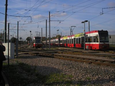
Therapia Lane depot, Tram depot in Sutton, England

Therapia Lane depot is a tram maintenance facility in Sutton, South London, designed to service the local tram network and keep vehicles operational. It sits between two station areas and includes workshop tracks, storage spaces for multiple tram sets, and specialized equipment for repairs and maintenance work.

The facility opened in 1998 on land where old railway sidings once stood, becoming part of the new Croydon Tramlink system expansion. It was built to provide the infrastructure needed for operating a modern tram network in this part of South London.

The depot serves as a working hub that keeps the local tram network running smoothly for thousands of daily commuters across South London. It represents an important part of how the region moves people around and stays connected through public transport.

The depot is not open to the general public as it is an active working facility for Transport for London's operations. Those interested in local transport can observe the tram network in action by visiting nearby stations or riding the tram itself to understand how the system functions.

A British Transport Police base operates on the site to monitor security across the entire tram network. This specialized police unit works behind the scenes to keep the system secure for its daily passengers.

The community of curious travelers

AroundUs brings together thousands of curated places, local tips, and hidden gems, enriched daily by 60,000 contributors worldwide.

Start exploring
GPS coordinates
51.38710,-0.13420
Latest update
December 14, 2025 12:26
Around this place
Beddington Zero Energy Development
United Kingdom

Beddington Zero Energy Development

1.6 km
Mitcham Common
United Kingdom

Mitcham Common

1.1 km
Croydon Mosque
United Kingdom

Croydon Mosque

1.5 km
Wandle Park
United Kingdom

Wandle Park

2.1 km
Cranmer Green
United Kingdom

Cranmer Green

2.2 km
Church of St Saviour
United Kingdom

Church of St Saviour

2 km
Parish Church of St Mary the Virgin
United Kingdom

Parish Church of St Mary the Virgin

1.8 km
Vue Purley Way
United Kingdom

Vue Purley Way

1.2 km
Church of St Stephen
United Kingdom

Church of St Stephen

2 km
Carew Manor Dovecote
United Kingdom

Carew Manor Dovecote

1.7 km
West Croydon United Reformed Church
United Kingdom

West Croydon United Reformed Church

1.7 km
Wallington Bridge
United Kingdom

Wallington Bridge

2.2 km
Bidder Memorial
United Kingdom

Bidder Memorial

1.8 km
The Parish Church of St Philip - Home to Libera
United Kingdom

The Parish Church of St Philip - Home to Libera

2.1 km
Boundary Walls To Beddington Place Along East Side Of Churchyard And Along Church Lane
United Kingdom

Boundary Walls To Beddington Place Along East Side Of Churchyard And Along Church Lane

1.8 km
335-347, Purley Way
United Kingdom

335-347, Purley Way

2.1 km
Wall To South West Of Beddington Park Cottages
United Kingdom

Wall To South West Of Beddington Park Cottages

1.7 km
Gates And Wrought Iron Screen At West Entrance To Beddington Place
United Kingdom

Gates And Wrought Iron Screen At West Entrance To Beddington Place

1.7 km
Lychgate At West Entrance To Churchyard Of St Mary's
United Kingdom

Lychgate At West Entrance To Churchyard Of St Mary's

1.8 km
Beddington Place (great Hall Only)
United Kingdom

Beddington Place (great Hall Only)

1.7 km
Beddington Place (2 End Wings)
United Kingdom

Beddington Place (2 End Wings)

1.7 km
351, Purley Way
United Kingdom

351, Purley Way

2.2 km
East Lodge
United Kingdom

East Lodge

1.7 km
Queen's Road Hospital (Entrance Block)
United Kingdom

Queen's Road Hospital (Entrance Block)

2.1 km
Lychgate At Entrance To West Churchyard Extension
United Kingdom

Lychgate At Entrance To West Churchyard Extension

1.8 km
282, London Road
United Kingdom

282, London Road

2.2 km
Boundary Walls To Extension Of Churchyard To West Of Church Road
United Kingdom

Boundary Walls To Extension Of Churchyard To West Of Church Road

1.8 km
Lamp Standard In Churchyard To South West Of Church Tower
United Kingdom

Lamp Standard In Churchyard To South West Of Church Tower

1.8 km
Show the full map
« Therapia Lane depot - Tram depot in Sutton, England » is provided by Around Us (aroundus.com). Images and texts are derived from Wikimedia project under a Creative Commons license. You are allowed to copy, distribute, and modify copies of this page, under the conditions set by the license, as long as this note is clearly visible.

Discover hidden gems everywhere you go!

From secret cafés to breathtaking viewpoints, skip the crowded tourist spots and find places that match your style. Our app makes it easy with voice search, smart filtering, route optimization, and insider tips from travelers worldwide. Download now for the complete mobile experience.

Around Us App Screenshot

A unique approach to discovering new places

Le Figaro

All the places worth exploring

France Info

A tailor-made excursion in just a few clicks

20 Minutes

Around Us
Travel Guide & Maps
Download

Send to your phone

QR Code
1

Open the camera app on your mobile.

2

Point at the QR code with your camera. A notification will appear.

3

Tap the notification to open the link.