Wandle Park, Urban park in Waddon, United Kingdom.
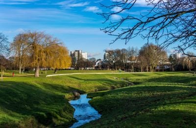
Wandle Park is an urban park where the River Wandle runs through the grounds, connecting areas with a bandstand, tennis courts, basketball facilities, and garden spaces. The entire site spans around 8.5 hectares with multiple entry points distributed around the perimeter.
The site emerged in 1890 from two watermeadows named Frog Mead and Stubbs Mead when Croydon Corporation transformed the land into a public recreation area. This conversion was part of the early push to create green spaces for the growing urban population.
The park serves as a gathering place where neighbors participate in community gardening and attend events at the bandstand throughout the seasons. These activities shape how local people spend their time outdoors together.
The tram network with Route 3 connects the park directly through the nearby Wandle Park station to the rest of the city. Multiple entry points are spread around the grounds, making it easy for visitors to access from different directions.
The River Wandle ran underground from 1967 until 2012 when major restoration work brought the waterway back to the surface. This return of the river fundamentally changed how the landscape appears and functions today.
The community of curious travelers
AroundUs brings together thousands of curated places, local tips, and hidden gems, enriched daily by 60,000 contributors worldwide.