White Limestone Formation, Geological formation near Oxford, England.
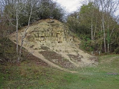
The White Limestone Formation is a geological unit in central England composed of pale yellow limestone layers with varying grain structures. These deposits form visible outcrops at several locations and display the typical features of marine sediments from the Jurassic era.
This limestone formation developed in the Middle Jurassic period roughly 168 million years ago in a shallow sea and was deposited through biological and chemical processes. Since then it has remained an exposed window into the past, preserving fossils and traces of marine creatures.
The formation's quarries, including Shipton-on-Cherwell and Woodeaton, provide essential research sites for paleontologists studying Jurassic-era vertebrate remains.
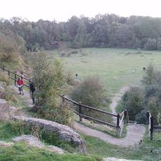
The formation is accessible at several quarry sites, particularly near Oxford, where exposed surfaces clearly show the rock layers. Visitors should bring appropriate weather gear and note that some areas may have limited or irregular access.
Sites like Woodeaton Quarry have yielded remains of early mammals from the Jurassic period, creatures that rarely survived as stone records. These discoveries offer rare glimpses into mammal life during an era when dinosaurs still dominated the world.
Location: England
GPS coordinates: 51.87500,-1.28400
Latest update: December 14, 2025 18:07
Bletchingdon Park
2.1 km
Kirtlington Quarry
0 m
Church of St Nicholas
1.8 km
Church of St Giles, Bletchingdon
2.2 km
Church of St Mary, Kirtlington
722 m
Park Gate House
2.3 km
The Blacks Head Public House
2.3 km
Oxford Canal Bridge At Pigeons Lock
836 m
The Dashwood Arms Public House
625 m
Rock Of Gibraltar Public House
2 km
Old Red Lion
2.4 km
The Oxford Arms Public House And Adjoining Cottage
593 m
Canal Bridge Approximately 60 Metres West Of The Rock Of Gibraltar Public House
2.1 km
Kirtlington Park
1.4 km
Squirrel's Drey
2.4 km
The Post Office Stores
2.4 km
Lower Whitehill Farmhouse
2 km
The Manor House And Attached Outbuilding Range
670 m
Chest tomb approximately 6 metres east of chancel of Church of St Giles
2.2 km
Monk's Head
2.3 km
The Malt House
2.4 km
Village Farmhouse
2.4 km
Glendale
2.4 km
Oxford Canal Northbrook Bridge (That Part In Kirtlington Civil Parish)
2.1 km
The Row
2.4 km
Milestone, Church Road; end of drive to Church Road House
2.3 km
Bletchingdon Park, stables and attached walls approximately 150 metres east north east of Bletchingdon Park
2.2 km
Milestone, by Church, on lane by Bletchingdon Park, in front of wall around church
2.2 kmVisited this place? Tap the stars to rate it and share your experience / photos with the community! Try now! You can cancel it anytime.
Discover hidden gems everywhere you go!
From secret cafés to breathtaking viewpoints, skip the crowded tourist spots and find places that match your style. Our app makes it easy with voice search, smart filtering, route optimization, and insider tips from travelers worldwide. Download now for the complete mobile experience.
A unique approach to discovering new places❞
— Le Figaro
All the places worth exploring❞
— France Info
A tailor-made excursion in just a few clicks❞
— 20 Minutes