Enable Location

We need your location to show you interesting places around you

Discover nearby places

Find interesting locations and hidden gems around you

Precise directions

Get accurate directions and distances to places

Your location is never shared with other users. It's only used when you tap the location button.

Bar Hill Roman fort

Log in to your account

Save your favorite places
Create custom travel routes
Rate and review places
Access the full interactive map
Continue with Google
Continue with Apple
Continue with email
By continuing, you accept our Terms and Conditions and our Privacy Policy
Create an account
Add to collection
Map
Suggest a change
Share

Bar Hill Roman fort, Roman military fort in East Dunbartonshire, Scotland.

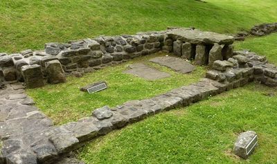
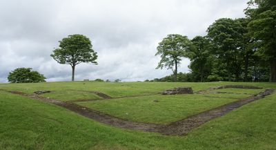
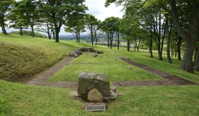
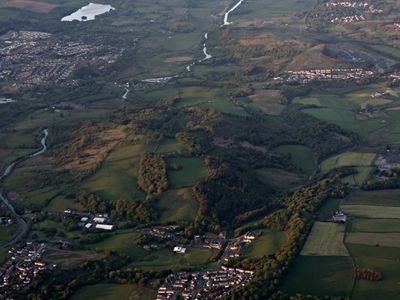
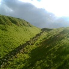
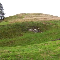
Bar Hill Roman fort was a military installation perched on a hilltop with commanding views over the Kelvin Valley in northern Scotland. The visible remains include stone foundations of key structures such as the headquarters building, defensive gates, and bathing facilities that reveal the layout of a Roman garrison.

The fort was built around 142 CE as part of the Antonine Wall system, a defensive line stretching across Scotland that marked the northwestern extent of Roman control in Britain. It remained occupied for roughly a century before being abandoned as Roman power withdrew from the region.

The site served as a crucial stronghold for Roman soldiers stationed at the empire's edge in Britain. Walking through the remains, visitors get a sense of how this garrison functioned as a military community far from Rome.

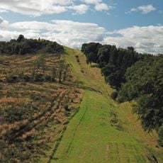
The site is open year-round and accessible via a walking path from Twechar village, though a steady uphill climb of about 20 to 30 minutes is required to reach it. Wear comfortable shoes and check weather conditions before visiting, as the hilltop can be exposed and wet.

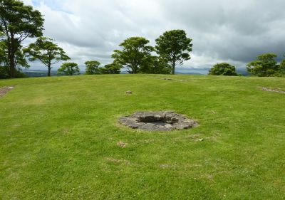
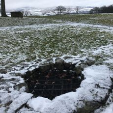
A deep well within the fort preserved everyday Roman items like leather shoes, bones, and coins that offer glimpses into the lives of soldiers and their families stationed here. These finds reveal details about real people who made this distant outpost their home.

Location: East Dunbartonshire

Location: Kirkintilloch

Part of: Antonine Wall, Bar Hill, rampart, ditch, fort and Military Way

GPS coordinates: 55.95889,-4.07211

Latest update: December 11, 2025 09:21

Photos
Around this place
Antonine Wall
United Kingdom

Antonine Wall

957 m
Market Chambers, Kilsyth
United Kingdom

Market Chambers, Kilsyth

2.2 km
Kilsyth, Howe Street, Burial-ground
United Kingdom

Kilsyth, Howe Street, Burial-ground

1.6 km
United Kingdom

Kilsyth, 30 Low Craigends, St Patrick's Roman Catholic Church

2.2 km
Kilsyth Parish Church
United Kingdom

Kilsyth Parish Church

2.1 km
Pump, Market Square, Kilsyth
United Kingdom

Pump, Market Square, Kilsyth

2.2 km
Bar Hill, Roman temporary camp SW of
United Kingdom

Bar Hill, Roman temporary camp SW of

176 m
United Kingdom

Twechar, Forth And Clyde Canal, Shirva Stables

1.7 km
United Kingdom

Kilsyth, 8 - 9 Market Square

2.2 km
United Kingdom

Kilsyth, 55-63 Main Street

2.2 km
Castle Hill
United Kingdom

Castle Hill

247 m
Antonine Wall, Bar Hill, rampart, ditch, fort and Military Way
United Kingdom

Antonine Wall, Bar Hill, rampart, ditch, fort and Military Way

53 m
United Kingdom

Kilsyth, 6 - 7 Market Square

2.2 km
United Kingdom

Antonine Wall, Girnal Hill to B802 road, Croy

1.4 km
United Kingdom

Bar Hill (Samian Ware Discovery Site)

77 m
United Kingdom

Antonine Wall, N of Alexander Avenue, Twechar

1.3 km
United Kingdom

Antonine Wall, Twechar Main Street to Bar Hill

274 m
United Kingdom

Antonine Wall, E edge of Strone Plantation to Girnal Hill

948 m
United Kingdom

Antonine Wall, B802 to N of Cuilmuir View, Croy

1.6 km
United Kingdom

Old School, Easterton

1.9 km
United Kingdom

Twechar, Roman temporary camp NW of St John of the Cross RC Church

1 km
United Kingdom

Croy Hill (Samian Ware Discovery Site)

1.8 km
United Kingdom

Brownville, Balmalloch Road, Kilsyth

2.1 km
United Kingdom

Dovecot, Auchinvole Castle

1.1 km
United Kingdom

36–42 Main Street, Kilsyth

2.2 km
United Kingdom

Scenic viewpoint

179 m
United Kingdom

Scenic viewpoint

246 m
United Kingdom

Scenic viewpoint

1.8 km
Show the full map
Reviews

Visited this place? Tap the stars to rate it and share your experience / photos with the community! Try now! You can cancel it anytime.

« Bar Hill Roman fort - Roman military fort in East Dunbartonshire, Scotland » is provided by Around Us (aroundus.com). Images and texts are derived from Wikimedia project under a Creative Commons license. You are allowed to copy, distribute, and modify copies of this page, under the conditions set by the license, as long as this note is clearly visible.

Discover hidden gems everywhere you go!

From secret cafés to breathtaking viewpoints, skip the crowded tourist spots and find places that match your style. Our app makes it easy with voice search, smart filtering, route optimization, and insider tips from travelers worldwide. Download now for the complete mobile experience.

Around Us App Screenshot

A unique approach to discovering new places

Le Figaro

All the places worth exploring

France Info

A tailor-made excursion in just a few clicks

20 Minutes