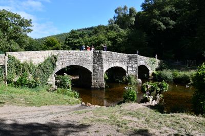
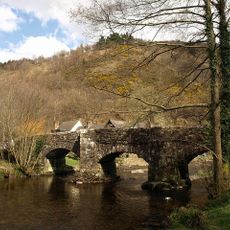
Fingle Bridge, Granite deck arch bridge in Dartmoor National Park, England
Fingle Bridge is a stone arch bridge spanning the River Teign with three arches and distinctive triangular cutwaters. These cutwaters rise upward to form small sheltered areas for pedestrians passing across.
Built in the 17th century, the bridge served as a key crossing for packhorses carrying grain and timber through the Teign Gorge. This trade route established it as an essential link in the region.
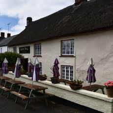
The tea shelter on the north side was established in 1897 and has remained a gathering place for walkers and fishermen ever since. Today it continues to serve visitors seeking refreshment during their time in the gorge.
The bridge connects to several walking trails throughout Dartmoor National Park and provides free parking on both sides. Access is straightforward, and the location suits walkers exploring the wider countryside.
The name comes from an old word meaning 'to catch' and refers to fishing in this river section. The location became a favored spot for anglers who took advantage of the river's fish populations.
Location: Moretonhampstead
Location: Drewsteignton
Made from material: granite
GPS coordinates: 50.69550,-3.78099
Latest update: December 9, 2025 18:43
Drewe Arms
1.2 km
Cranbrook Castle
1 km
Prestonbury Castle
476 m
Church of the Holy Trinity
1.1 km
The Old Inn
1.2 km
Mudge Headstone Approximately 12 Metres East Of Chancel Of Church Of The Holy Trinity
1.1 km
K6 Telephone Kiosk
1.1 km
Ashplants, Fingle Cottage Rookwood Cottage
1.1 km
Primrose Cottage
1.1 km
Glebe Cottages
1.1 km
Church Rooms
1.1 km
Church Gate Cottages
1.1 km
Preston Cottages
695 m
Adjacent Piller And Mardon Headstones Approximately 12 Metres North-East Of Chancel Of Church Of Holy Trinity
1.1 km
Anonymous Chest Tomb Approximately 5 Metres South East Of Aisle Of Church Of Holy Trinity
1.1 km
Stevens Headstone Approximately 1.5 Metres East Of Chancel Of Church Of Holy Trinity
1.1 km
Broadmeadow
1.2 km
Edgecombe
1.1 km
Anonymous Chest Tomb Approximately 2 Metres South Of Aisle Of Church Of Holy Trinity
1.1 km
Series Of Adjacent Headstones Lining Both Sides Of Path Approximately 3-9 Metres South Of Church Porch
1.1 km
Clysterhayes
1.2 km
Hillside House
1.1 km
Lady House
1.1 km
Bolt Headstone Approximately 10 Metres East North East Of Chancel Of Church Of Holy Trinity
1.1 km
Churchyard Lych Gate Adjoining North Side Of Church Cottage
1.1 km
Drewsteignton War Memorial
1.2 km
Snell Headstone Approximately 1.5 Metres East Of Chancel Of Church Of Holy Trinity
1.1 km
Wayside Stone At Sx 742 887
1.2 kmVisited this place? Tap the stars to rate it and share your experience / photos with the community! Try now! You can cancel it anytime.
Discover hidden gems everywhere you go!
From secret cafés to breathtaking viewpoints, skip the crowded tourist spots and find places that match your style. Our app makes it easy with voice search, smart filtering, route optimization, and insider tips from travelers worldwide. Download now for the complete mobile experience.
A unique approach to discovering new places❞
— Le Figaro
All the places worth exploring❞
— France Info
A tailor-made excursion in just a few clicks❞
— 20 Minutes