Enable Location

We need your location to show you interesting places around you

Discover nearby places

Find interesting locations and hidden gems around you

Precise directions

Get accurate directions and distances to places

Your location is never shared with other users. It's only used when you tap the location button.

Gamelands stone circle

Log in to your account

Start exploring — it's free

Trusted by 62,918 travelers worldwide

Continue with Google
Continue with Apple
or

We will send you a code to connect

By continuing, you accept our Terms and Conditions and our Privacy Policy

Check your inbox

We've sent a pincode in your inbox. Please enter the code below.

Gamelands stone circle
Discussion Reviews 1 Photos
1.7k Popularity

Gamelands stone circle, Stone circle in Orton, England.

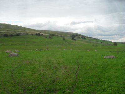
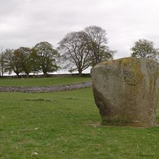
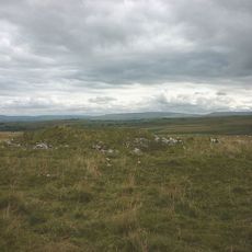
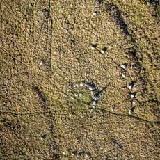
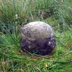
Gamelands stone circle is an oval-shaped monument at the base of Knott Scar in Cumbria, measuring about 44.5 by 37.5 meters across. The stones composing it are mostly red granite, with one distinctive limestone block breaking the uniformity.

The monument originally contained around 40 stones before farm work in 1862 disturbed the arrangement. Today roughly 33 stones remain standing, most of them reduced to less than one meter in height.

The circle holds meaning as a gathering place from prehistoric times, where communities gathered for rituals and ceremonies. Walking around it today, you can sense how people once used this elevated ground for coming together.

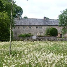
The location sits roughly one mile east of Orton village and remains accessible year-round to explore. The low height of the stones and flat terrain make it easy to walk around and view the monument from different angles.

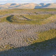
Excavations near the circle uncovered worked flints and a probable prehistoric stone cist. These findings suggest people spent time here carrying out different kinds of activities over an extended period.

The community of curious travelers

AroundUs brings together thousands of curated places, local tips, and hidden gems, enriched daily by 60,000 contributors worldwide.

Start exploring
Location
GPS coordinates
54.46760,-2.55690
Latest update
December 14, 2025 13:05
Around this place
Settle to Carlisle Line
United Kingdom

Settle to Carlisle Line

8.5 km
Flass
United Kingdom

Flass

7.6 km
Shap Stone Avenue
United Kingdom

Shap Stone Avenue

8.8 km
Castle Folds Romano-British defended stone hut circle settlement and medieval shieling
United Kingdom

Castle Folds Romano-British defended stone hut circle settlement and medieval shieling

1.5 km
All Saints Church, Orton
United Kingdom

All Saints Church, Orton

1.8 km
St Lawrence's Church, Crosby Ravensworth
United Kingdom

St Lawrence's Church, Crosby Ravensworth

6.9 km
Pate Hole
United Kingdom

Pate Hole

5.5 km
Smardale Gill Viaduct
United Kingdom

Smardale Gill Viaduct

8.8 km
Church of St Peter
United Kingdom

Church of St Peter

6.5 km
Church of St James
United Kingdom

Church of St James

4.4 km
Smardale Bridge
United Kingdom

Smardale Bridge

8.3 km
Well To East Of Grange Hall
United Kingdom

Well To East Of Grange Hall

5.3 km
Milepost (325 Yards North Of Turn To Sleddale)
United Kingdom

Milepost (325 Yards North Of Turn To Sleddale)

8.8 km
Britannia Monument And Enclosure Walls To North Of Shap Wells Hotel (At Ngr Ny 579 098)
United Kingdom

Britannia Monument And Enclosure Walls To North Of Shap Wells Hotel (At Ngr Ny 579 098)

6.3 km
Beacon Monument
United Kingdom

Beacon Monument

1.8 km
Gaythorne Hall
United Kingdom

Gaythorne Hall

5.2 km
Footbridge Over Dale Beck West Of Roadbridge
United Kingdom

Footbridge Over Dale Beck West Of Roadbridge

6.1 km
Crosby Garrett Viaduct at NT 727 093
United Kingdom

Crosby Garrett Viaduct at NT 727 093

8.8 km
Petty Hall
United Kingdom

Petty Hall

1.8 km
Hollin Stump round cairn
United Kingdom

Hollin Stump round cairn

3.7 km
Footbridge Over Dalesbank Beck To South Of Church
United Kingdom

Footbridge Over Dalesbank Beck To South Of Church

6.9 km
Oddendale concentric stone circle
United Kingdom

Oddendale concentric stone circle

6.8 km
Drybeck Hall And Attached Buildings
United Kingdom

Drybeck Hall And Attached Buildings

7.8 km
Gaisgill packhorse bridge
United Kingdom

Gaisgill packhorse bridge

1.7 km
Hardendale Hall With Adjoinng Byres And Scullery
United Kingdom

Hardendale Hall With Adjoinng Byres And Scullery

8.6 km
Grange Hall And Adjoining Buildings
United Kingdom

Grange Hall And Adjoining Buildings

5.2 km
Crosby Ravensworth stone cross
United Kingdom

Crosby Ravensworth stone cross

6.9 km
Marker Stone On East Side Of Old Turnpike Road To South Of Shap (At Ngr 553 069)
United Kingdom

Marker Stone On East Side Of Old Turnpike Road To South Of Shap (At Ngr 553 069)

8.7 km
Show the full map
Reviews
Share your experience

No review yet

Discussions
Start a discussion...

No discussion yet

« Gamelands stone circle - Stone circle in Orton, England » is provided by Around Us (aroundus.com). Images and texts are derived from Wikimedia project under a Creative Commons license. You are allowed to copy, distribute, and modify copies of this page, under the conditions set by the license, as long as this note is clearly visible.

Discover hidden gems everywhere you go!

From secret cafés to breathtaking viewpoints, skip the crowded tourist spots and find places that match your style. Our app makes it easy with voice search, smart filtering, route optimization, and insider tips from travelers worldwide. Download now for the complete mobile experience.

Around Us App Screenshot

A unique approach to discovering new places

Le Figaro

All the places worth exploring

France Info

A tailor-made excursion in just a few clicks

20 Minutes

Around Us
Travel Guide & Maps
Download

Send to your phone

QR Code
1

Open the camera app on your mobile.

2

Point at the QR code with your camera. A notification will appear.

3

Tap the notification to open the link.