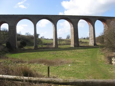
Pensford Viaduct, Railway viaduct in Pensford, England
Pensford Viaduct is a stone and brick railway bridge that spans across the River Chew valley using a series of sixteen arches. The structure connects the two sides of the valley through a solid construction where red brick details appear between the stone piers.
Construction of the viaduct started in 1874 and was carried out by J. Perry from Tredegar Works. The structure served the Bristol and North Somerset Railway until the line closed in 1968.
The structure shapes the local landscape with its stone piers and red brick surfaces that stand out from the valley. Residents and visitors recognize this viaduct as a Victorian landmark that defines the visual character of the area.
The viaduct is accessible from several walking paths that lead through the valley and offer different viewing angles of the structure. It is advisable to wear sturdy shoes since the surrounding paths can be uneven and muddy.
In the 1980s the structure was put up for sale at an extremely low price, but the costs of keeping it in good condition discouraged potential buyers. This episode reveals how even impressive Victorian engineering can become a financial burden for owners.
Location: Publow
GPS coordinates: 51.37080,-2.55150
Latest update: December 10, 2025 20:02
Stanton Drew stone circles
1.7 km
Maes Knoll Camp
2.9 km
St Thomas à Becket Church, Pensford
120 m
The Round House, Stanton Drew
2.1 km
Folly Farm, Somerset
3.4 km
Church of St Margaret, Queen Charlton
3.7 km
Church of All Saints, Publow
874 m
Church of St Mary the Virgin, Stanton Drew
2 km
Church of St Leonard, Chelwood
1.9 km
Church of St Mary
3 km
Holy Trinity Church, Norton Malreward
1.9 km
The Court
2 km
Bridge Over The River Chew
168 m
The Gamekeeper Public House
3.1 km
George And Dragon Public House
310 m
Bridge House
174 m
Milestone At National Grid Reference St 6198 6703
3.4 km
Large irregular stone circle at Stanton Drew south east of Church Farm
1.9 km
Round House
300 m
Bridge Over River Chew
2 km
Hunstrete House, Flank Wall And West Wing
3.5 km
Stone cove at Stanton Drew 25m south west of St Mary's Church
2 km
Arcade About 200 Metres North West Of Hunstrete House
3.3 km
Milestone At National Grid Reference St 6169 6506
1.4 km
Manor Farmhouse
3.8 km
Milestone, New Road, Pensford
278 m
Milestone, Red Hill, N of Clutton
3.1 km
Archway To North Of Manor Farmhouse And Opposite Manor House
3.7 kmVisited this place? Tap the stars to rate it and share your experience / photos with the community! Try now! You can cancel it anytime.
Discover hidden gems everywhere you go!
From secret cafés to breathtaking viewpoints, skip the crowded tourist spots and find places that match your style. Our app makes it easy with voice search, smart filtering, route optimization, and insider tips from travelers worldwide. Download now for the complete mobile experience.
A unique approach to discovering new places❞
— Le Figaro
All the places worth exploring❞
— France Info
A tailor-made excursion in just a few clicks❞
— 20 Minutes