Maes Knoll Camp

Log in to your account

AroundUs is a community-driven map of interesting places, built by curious explorers like you. It grows with every review, story, and photo you share.
Connect to save your favorite spots, contribute locations, and create personalized routes.
Continue with Google
Continue with Apple
Continue with X
Continue with Facebook
Continue with email
By continuing, you accept our Terms and Conditions and our Privacy Policy
Create an account
Add to collection
Map
Suggest a change
Share

Maes Knoll Camp, Iron Age partial contour fort in Norton Malreward, England
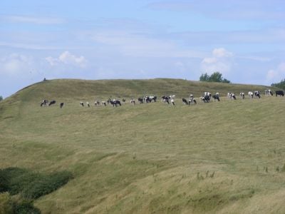
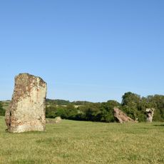
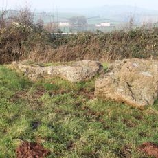
Maes Knoll Camp is an Iron Age fort in Norton Malreward, England, located on elevated terrain overlooking the surrounding countryside. The site features defensive ramparts encircling a central plateau, with steep natural slopes forming part of its protective structure.

The Dobuni, a Celtic tribe, built this fort around 250 BC on a naturally elevated hilltop. They reinforced the site with earthen ramparts and ditches that capitalized on the existing steep terrain for defensive advantage.

Local tales connect the site to Sir John Hautville, a medieval knight known for feats of strength and believed to have influenced the landscape.

This fort sits at about 197 meters in elevation, providing commanding views across the landscape toward Bristol, Bath, and the Cotswold Hills from its summit. Walking the ramparts is possible year-round, though muddy ground conditions can make footing uneven after heavy rain.

During World War II, the Home Guard established a small observation post on the hilltop to watch for enemy aircraft over Bristol. This modern military chapter sits surprisingly alongside the site's ancient Celtic origins.

Location: Norton Malreward

Location: Bath

GPS coordinates: 51.39210,-2.57560

Latest update: December 10, 2025 16:28

Photos
Around this place
Stanton Drew stone circles
United Kingdom

Stanton Drew stone circles

2.8 km
St Thomas à Becket Church, Pensford
United Kingdom

St Thomas à Becket Church, Pensford

3 km
Pensford Viaduct
United Kingdom

Pensford Viaduct

2.9 km
Lakeshore, Bristol
United Kingdom

Lakeshore, Bristol

3.2 km
The Round House, Stanton Drew
United Kingdom

The Round House, Stanton Drew

2.5 km
Counterslip Baptist Church
United Kingdom

Counterslip Baptist Church

2.9 km
Holy Cross Inns Court Vicarage
United Kingdom

Holy Cross Inns Court Vicarage

3.3 km
Dundry Main Road South Quarry
United Kingdom

Dundry Main Road South Quarry

3.5 km
Church of All Saints, Publow
United Kingdom

Church of All Saints, Publow

2.9 km
Church of St Mary the Virgin, Stanton Drew
United Kingdom

Church of St Mary the Virgin, Stanton Drew

2.9 km
Holy Trinity Church, Norton Malreward
United Kingdom

Holy Trinity Church, Norton Malreward

1 km
St. Augustine's Church, Whitchurch, Bristol
United Kingdom

St. Augustine's Church, Whitchurch, Bristol

1.7 km
The Court
United Kingdom

The Court

2.8 km
Church of St Nicholas
United Kingdom

Church of St Nicholas

1.9 km
Bridge Over The River Chew
United Kingdom

Bridge Over The River Chew

3 km
George And Dragon Public House
United Kingdom

George And Dragon Public House

3 km
Bridge House
United Kingdom

Bridge House

3 km
Large irregular stone circle at Stanton Drew south east of Church Farm
United Kingdom

Large irregular stone circle at Stanton Drew south east of Church Farm

3 km
Little Thatch
United Kingdom

Little Thatch

2.7 km
Milestone At National Grid Reference St 6198 6703
United Kingdom

Milestone At National Grid Reference St 6198 6703

2.2 km
Roman Catholic Church of St Bernadette
United Kingdom

Roman Catholic Church of St Bernadette

2.7 km
Round House
United Kingdom

Round House

3 km
Milestone At National Grid Reference St 6169 6506
United Kingdom

Milestone At National Grid Reference St 6169 6506

1.9 km
Stone cove at Stanton Drew 25m south west of St Mary's Church
United Kingdom

Stone cove at Stanton Drew 25m south west of St Mary's Church

3 km
Manor Farmhouse
United Kingdom

Manor Farmhouse

2.2 km
Bridge Over River Chew
United Kingdom

Bridge Over River Chew

2.6 km
Milestone, New Road, Pensford
United Kingdom

Milestone, New Road, Pensford

3.1 km
Archway To North Of Manor Farmhouse And Opposite Manor House
United Kingdom

Archway To North Of Manor Farmhouse And Opposite Manor House

3.4 km
Show the full map
Reviews

Visited this place? Tap the stars to rate it and share your experience / photos with the community! Try now! You can cancel it anytime.

« Maes Knoll Camp - Iron Age partial contour fort in Norton Malreward, England » is provided by Around Us (aroundus.com). Images and texts are derived from Wikimedia project under a Creative Commons license. You are allowed to copy, distribute, and modify copies of this page, under the conditions set by the license, as long as this note is clearly visible.

Discover hidden gems everywhere you go!

From secret cafés to breathtaking viewpoints, skip the crowded tourist spots and find places that match your style. Our app makes it easy with voice search, smart filtering, route optimization, and insider tips from travelers worldwide. Download now for the complete mobile experience.

Around Us App Screenshot

A unique approach to discovering new places

Le Figaro

All the places worth exploring

France Info

A tailor-made excursion in just a few clicks

20 Minutes