Enable Location

We need your location to show you interesting places around you

Discover nearby places

Find interesting locations and hidden gems around you

Precise directions

Get accurate directions and distances to places

Your location is never shared with other users. It's only used when you tap the location button.

Grimsby Old Blockhouse

Log in to your account

Start exploring — it's free

Trusted by 63,527 travelers worldwide

Continue with Google
Continue with Apple
or

We will send you a code to connect

By continuing, you accept our Terms and Conditions and our Privacy Policy

Check your inbox

We've sent a pincode in your inbox. Please enter the code below.

Grimsby Old Blockhouse
Discussion Reviews 1 Photos
1.6k Popularity

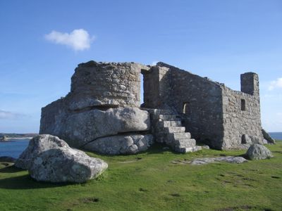
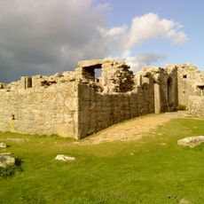
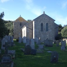
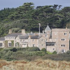
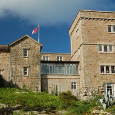
Grimsby Old Blockhouse, 16th-century coastal fortification in Tresco, United Kingdom.

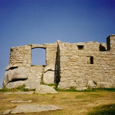
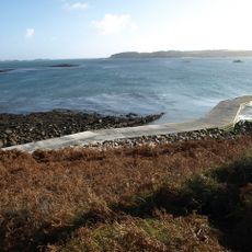
Grimsby Old Blockhouse is a fortified stone structure on Blockhouse Point that overlooks Old Grimsby Harbour and the beaches below. The thick walls were built to defend against sea-based invasions and protect the harbor area from attack.

This fortification was built in the 16th century under Henry VIII to protect the coast against French invasion threats. During the English Civil War, it was occupied by both sides and played a defensive role in regional conflicts.

The blockhouse demonstrates how Tudor engineers protected maritime regions and served as part of broader coastal defense strategies. Its sturdy walls still stand today as evidence of the practical military engineering approaches of that era.

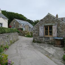
Access is via a walking path that takes about twenty minutes from Old Grimsby and runs along the coastline with good views. Wear shoes with good grip, especially if conditions are wet or windy.

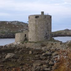
This blockhouse is one of three military structures on Tresco that form a defensive triangle, showing how thoroughly the island was protected against attack. Together with Cromwell's Castle and King Charles' Castle, it creates an important network of regional defense history.

The community of curious travelers

AroundUs brings together thousands of curated places, local tips, and hidden gems, enriched daily by 60,000 contributors worldwide.

Start exploring
Location
Part of
Mid-16th century blockhouse and ramparts with adjacent walling and occupation deposits at Block House Point
GPS coordinates
49.95852,-6.32752
Latest update
December 14, 2025 13:00
Around this place
Tresco Abbey Gardens
United Kingdom

Tresco Abbey Gardens

1.4 km
Cromwell's Castle
United Kingdom

Cromwell's Castle

1.6 km
King Charles's Castle
United Kingdom

King Charles's Castle

1.6 km
Round Island Lighthouse
United Kingdom

Round Island Lighthouse

2.3 km
Halangy Down
United Kingdom

Halangy Down

3.3 km
St Nicholas's Church, Tresco
United Kingdom

St Nicholas's Church, Tresco

541 m
Tresco Priory
United Kingdom

Tresco Priory

1.2 km
Bant's Carn
United Kingdom

Bant's Carn

3.4 km
All Saints' Church, Bryher
United Kingdom

All Saints' Church, Bryher

1.8 km
St Martin's Church, St Martin's
United Kingdom

St Martin's Church, St Martin's

3.1 km
Oliver's Battery
United Kingdom

Oliver's Battery

2 km
Halangy Down transmitting station
United Kingdom

Halangy Down transmitting station

3.3 km
Methodist Church
United Kingdom

Methodist Church

3.2 km
Valhalla Museum
United Kingdom

Valhalla Museum

1.4 km
Bar Point
United Kingdom

Bar Point

3.1 km
Mid-16th century blockhouse and ramparts with adjacent walling and occupation deposits at Block House Point
United Kingdom

Mid-16th century blockhouse and ramparts with adjacent walling and occupation deposits at Block House Point

16 m
Post-medieval smugglers' cache at Tresco Abbey, Tresco
United Kingdom

Post-medieval smugglers' cache at Tresco Abbey, Tresco

1.2 km
The Smith Monument On Abbey Hill
United Kingdom

The Smith Monument On Abbey Hill

1.3 km
Tresco Abbey
United Kingdom

Tresco Abbey

1.2 km
Post-medieval kelp pit on the western coast of Tinkler's Hill, St Martin's
United Kingdom

Post-medieval kelp pit on the western coast of Tinkler's Hill, St Martin's

2.1 km
Prehistoric entrance grave, the northern one of three on Cruther's Hill, St Martin's
United Kingdom

Prehistoric entrance grave, the northern one of three on Cruther's Hill, St Martin's

3.2 km
Prehistoric field systems, settlement and cairns, with post-medieval boundary and shelter on Northwethel
United Kingdom

Prehistoric field systems, settlement and cairns, with post-medieval boundary and shelter on Northwethel

860 m
Prehistoric linear boundary on Puffin Island
United Kingdom

Prehistoric linear boundary on Puffin Island

2.6 km
Entrance Grave, Samson
United Kingdom

Entrance Grave, Samson

3.6 km
Broad Ledge
United Kingdom

Broad Ledge

2 km
Ashvale Farmhouse
United Kingdom

Ashvale Farmhouse

2 km
Hulman
United Kingdom

Hulman

2.4 km
Carn Near
United Kingdom

Carn Near

2.1 km
Show the full map
Reviews
Share your experience

No review yet

Discussions
Start a discussion...

No discussion yet

« Grimsby Old Blockhouse - 16th-century coastal fortification in Tresco, United Kingdom » is provided by Around Us (aroundus.com). Images and texts are derived from Wikimedia project under a Creative Commons license. You are allowed to copy, distribute, and modify copies of this page, under the conditions set by the license, as long as this note is clearly visible.

Discover hidden gems everywhere you go!

From secret cafés to breathtaking viewpoints, skip the crowded tourist spots and find places that match your style. Our app makes it easy with voice search, smart filtering, route optimization, and insider tips from travelers worldwide. Download now for the complete mobile experience.

Around Us App Screenshot

A unique approach to discovering new places

Le Figaro

All the places worth exploring

France Info

A tailor-made excursion in just a few clicks

20 Minutes

Around Us
Travel Guide & Maps
Download

Send to your phone

QR Code
1

Open the camera app on your mobile.

2

Point at the QR code with your camera. A notification will appear.

3

Tap the notification to open the link.