Woodlands Fort, Victorian defensive fort in Plymouth, England
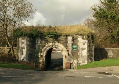
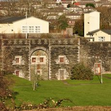
Woodlands Fort is a Victorian defensive fortification in Plymouth featuring earthwork walls, ramparts, and gun emplacements built from local stone and soil. The structure displays the typical layout of coastal defense installations from the 1860s.
Built in 1863 during tensions with France, it was part of a chain of fortifications protecting Plymouth's naval base and strategic harbors. This defensive work reflects Britain's strategy to secure its coasts against potential threats.
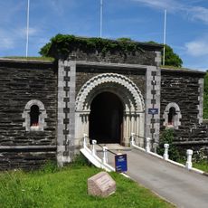
The fort displays Victorian military engineering through its earthwork design and gun placements that reveal how 19th-century Britain protected its coasts. Walking through the structures, you see the practical solutions soldiers used to organize defense and surveillance.
The site is open for walking exploration with display boards explaining key features, and guided tours are regularly offered to visitors. Wear suitable footwear as the ground can be uneven and some areas remain exposed to the elements.
The fort preserves original gun positions and barracks areas showing how soldiers actually lived and worked during the Victorian era. These surviving features offer direct insight into daily coastal defense operations.
Location: City of Plymouth
Inception: 1863
GPS coordinates: 50.41372,-4.15421
Latest update: December 14, 2025 13:05
Royal Albert Bridge
3.6 km
Tamar Bridge
3.5 km
Crownhill Fort
1.7 km
Warleigh House
2.8 km
Central Park, Plymouth
3.1 km
Tavy Bridge
3 km
Church of the Ascension, Crownhill
1.7 km
'The Ship', Derriford
2.5 km
Bowden Battery
2.8 km
Knowles Battery
790 m
Church of St Mary
1.5 km
Church of St Budeaux
1.6 km
Church of St Edward King of the West Saxons
3.1 km
Church of St Pancras
1.5 km
Church of Emmanuel
3.4 km
Southway Library
2.7 km
Hms Drake Clock Tower South East Of Main Gates And Attached Guardhouse
3.3 km
Peverell Library
2.3 km
North Prospect Library
2.5 km
Agaton Fort
1.5 km
Crownhill Library
1.7 km
Weston Mill Viaduct
2.9 km
Milestone Near Garden Wall West Of Cressy
1.8 km
Weston Mill Cemetery, Cross of Sacrifice, Plymouth
2.2 km
Tamerton Bridge
2.6 km
Milestone, Wolseley Road, Ford, SW of roundabout, opp. Esso garage, nr Milehouse
3 km
Milestone, Wolseley Road, by No. 366, Camels Head, E of "Headline Hair"
2.6 km
Milepost, Tamerton Foliot, Tavistock Road, by No. 332, Hareston (in cul de sac beside main road by end of old runway)
3 kmVisited this place? Tap the stars to rate it and share your experience / photos with the community! Try now! You can cancel it anytime.
Discover hidden gems everywhere you go!
From secret cafés to breathtaking viewpoints, skip the crowded tourist spots and find places that match your style. Our app makes it easy with voice search, smart filtering, route optimization, and insider tips from travelers worldwide. Download now for the complete mobile experience.
A unique approach to discovering new places❞
— Le Figaro
All the places worth exploring❞
— France Info
A tailor-made excursion in just a few clicks❞
— 20 Minutes