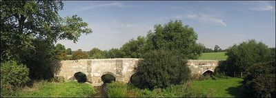
Thornborough Bridge, Medieval road bridge in Buckinghamshire, England
Thornborough Bridge is a limestone crossing spanning the River Great Ouse with multiple stone arches supporting its length. The structure displays carved ribbed vaults and decorative stonework, while the southern side features built-in widened sections that allowed people to step aside when passing each other.
The bridge was built during the late medieval period as a response to heavy river crossing traffic in the region. Major restoration work took place in the 1660s, with stone inscriptions carved to mark and commemorate the repairs made at that time.
The bridge represents the last standing medieval crossing of its kind in the county, serving as a physical link to how people historically moved across the river. Its enduring form shows how medieval engineers designed practical passages for both vehicles and pedestrians.
The bridge is straightforward to access from nearby roads and footpaths, with no special equipment or prior planning needed. The ground around it can become muddy depending on rainfall and season, so sturdy footwear is a good idea when visiting.
Two ancient Roman burial mounds sit just beyond the bridge in the eastern direction, connecting this crossing to Roman settlement patterns centuries before the medieval construction. These earthen monuments suggest the location held strategic value for movement and trade far earlier than the current stone structure was ever built.
The community of curious travelers
AroundUs brings together thousands of curated places, local tips, and hidden gems, enriched daily by 60,000 contributors worldwide.