Longdon-Upon-Tern aqueduct
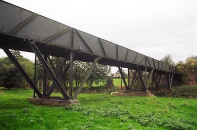
Longdon-Upon-Tern aqueduct, Navigable iron aqueduct in Longdon-on-Tern, England
Longdon-on-Tern aqueduct is a cast iron structure that carries an empty canal trough across the River Tern, resting on stone abutments below. It consists of four spans held up by iron uprights and diagonal bracing that create the channel for boats to pass over water.
Thomas Telford designed this cast iron aqueduct in 1796 after an earlier stone structure by William Clowes had been damaged by flooding. The shift to cast iron represented a major advance in how canal infrastructure could be built.
This aqueduct showcases an early form of industrial engineering during Britain's canal-building era when new materials and methods were being tested. The structure reflects how people solved practical problems of moving water and boats across rivers during rapid industrial change.
Access is available at any time through a public gate near the B5063 layby, allowing visitors to walk inside the empty canal trough. The structure is free to explore, though visitors should watch for uneven surfaces and remain aware of the height when standing on the iron frame.
This is the oldest surviving navigable cast iron aqueduct, remaining in its original location since construction. Its original iron trough and supports are still in place, showing how durable early cast iron engineering proved to be.
Location: Longdon-on-Tern
GPS coordinates: 52.73700,-2.56770
Latest update: December 10, 2025 20:01
Sunnycroft
5.8 km
Apley Castle
4.6 km
High Ercall Hall
3 km
St Michael's Church, High Ercall
2.9 km
Church of St Peter
3.7 km
All Hallows, Rowton
4.3 km
Church of All Saints
5.2 km
Church of St George
3.1 km
Church of St. Catherine
3.4 km
Church of St Michael
4.1 km
Christ Church
5.8 km
Church of St John the Baptist
4.9 km
Church of St Bartholomew
553 m
Church of St Chad
5.6 km
Clifton Cinema, Wellington
5.2 km
Gate Piers, Steps, Walls and War Memorial Lychgate
5.1 km
St Mary
2.9 km
Stable At Poynton Manor
5.2 km
Milepost Approximately 700 Yards South South West Of Orleton Hall
5.2 km
Ercall Mill Mill House
3.3 km
Mile Post South South East Of Wrekin Hospital
5.7 km
Wrockwardine War Memorial
3.6 km
The Round House Umbrella House
5 km
The Hall
4.2 km
Preston Hospital Including Screen And Gates In Front
6.1 km
Moated site, ridge and furrow cultivation remains and a building platform immediately north of Lower Grounds
2.4 km
Milestone, Whitchurch Road, nr jcn Apley Avenue
4.7 km
Milestone, Ercall Magna; opp. Poynton turn
4.6 kmVisited this place? Tap the stars to rate it and share your experience / photos with the community! Try now! You can cancel it anytime.
Discover hidden gems everywhere you go!
From secret cafés to breathtaking viewpoints, skip the crowded tourist spots and find places that match your style. Our app makes it easy with voice search, smart filtering, route optimization, and insider tips from travelers worldwide. Download now for the complete mobile experience.
A unique approach to discovering new places❞
— Le Figaro
All the places worth exploring❞
— France Info
A tailor-made excursion in just a few clicks❞
— 20 Minutes