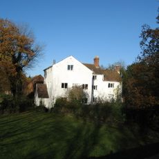
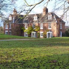
High Ercall Hall, Grade II listed manor house in Ercall Magna, England
High Ercall Hall is a three-story L-shaped house built from sandstone and brick, displaying five bays and three projecting gables across its exterior. The structure combines elements from different construction periods, reflecting changes made over the centuries.
The Newport family built this house in the late 16th century, with Sir Francis Newport adding major extensions around 1608. It served as a Royalist garrison during the English Civil War and endured several sieges before falling to Parliamentary forces in 1646.
The house reflects its origins tied to a prominent local family whose fortunes shaped the region for centuries, and the building remains a marker of gentry life in this part of England.
This is a private home with no public access to the interior, but you can see the outside from Shrewsbury Road in High Ercall. The front of the house is visible from the public road, giving a clear view of the main architectural features.
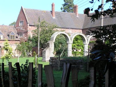
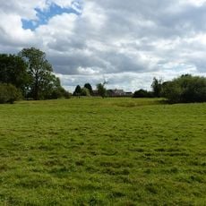
Stone arches from the original loggia survive as traces of a larger mansion that once stood beside the current house. These remains show that the original property was considerably more expansive than what visitors see today.
Location: Ercall Magna
Inception: 1608
GPS coordinates: 52.75290,-2.60276
Latest update: December 14, 2025 11:24
Haughmond Abbey
5.7 km
Moreton Corbet Castle
6.6 km
Longdon-Upon-Tern aqueduct
3 km
St Michael's Church, High Ercall
90 m
Church of St Lucia
6.4 km
Church of St Mary the Virgin
5.1 km
Church of St Mary
6.6 km
All Hallows, Rowton
3.3 km
Church of St George
3.1 km
Church of St Peter
6.2 km
Church of St. Catherine
6.2 km
Church of St. John the Baptist
6.6 km
Church of St Michael
4.5 km
Church of St Bartholomew
6.7 km
Church of St John the Baptist
4.8 km
Church of St Bartholomew
3.5 km
Moated site 140m east of St Mary's Church
5 km
St Mary
3.9 km
Stable At Poynton Manor
2.4 km
Moreton Mill
5.7 km
Ercall Mill Mill House
1.4 km
Ebury Hill
4.9 km
Milepost Approximately 425 Metres To South Of Field House
3.5 km
Wrockwardine War Memorial
6.1 km
Milepost Approximately 10 Metres To West Of Shawbury Bridge
5.1 km
The Hall
4.5 km
Moated site, ridge and furrow cultivation remains and a building platform immediately north of Lower Grounds
1.5 km
Milestone, Ercall Magna; opp. Poynton turn
2.3 kmVisited this place? Tap the stars to rate it and share your experience / photos with the community! Try now! You can cancel it anytime.
Discover hidden gems everywhere you go!
From secret cafés to breathtaking viewpoints, skip the crowded tourist spots and find places that match your style. Our app makes it easy with voice search, smart filtering, route optimization, and insider tips from travelers worldwide. Download now for the complete mobile experience.
A unique approach to discovering new places❞
— Le Figaro
All the places worth exploring❞
— France Info
A tailor-made excursion in just a few clicks❞
— 20 Minutes