Postbridge Clapper Bridge
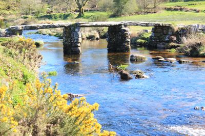
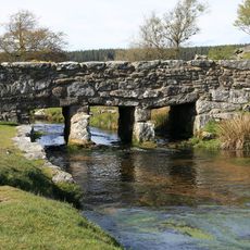
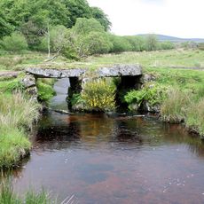
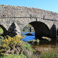
Postbridge Clapper Bridge, Medieval stone bridge in Dartmoor Forest, England
Postbridge Clapper Bridge is a medieval stone structure crossing the East Dart River with three large granite slabs resting on two central supporting piers. The design is straightforward and sturdy, built without mortar or complex techniques.
The structure was built in the 13th century to help transport tin from Dartmoor mines to processing centers. By the 1780s, a modern road bridge was constructed alongside it to handle increasing traffic.
The name comes from Anglo-Saxon language and refers to the practice of laying large flat stone slabs across water. When you walk across today, you experience the same simple crossing method that travelers have used for centuries.
The bridge is accessible year-round and located near walking paths that are easy to reach on foot. The granite surface can become slippery when wet, so take care when crossing.
Each of the three granite slabs is longer than 4 m (13 ft) and weighs about 8 tonnes, showing how medieval workers moved heavy materials. These massive stones were positioned without modern machinery and have held firm for centuries.
Location: Dartmoor Forest
Length: 12.95 m
Made from material: stone
GPS coordinates: 50.59410,-3.91110
Latest update: December 14, 2025 14:41
Wistman's Wood
4 km
Devonport Leat
3.9 km
Dartmoor National Park
2.6 km
Bellever Tor Cairns
2.7 km
Ring cairn with cist on Lakehead Hill
1.5 km
Roundy Park prehistoric enclosure and cairn with cist, 560m north east of Archerton
1.1 km
Church of St Gabriel
474 m
Clapper Bridge Across Walla Brook On Road From Cator To Bellever
2.5 km
Powder Mills Clapper Bridge
2.6 km
Smith Hill Farm
3.9 km
Statts Bridge
2.5 km
Kraps Ring
856 m
Stone alignment, hut circle settlement, medieval long house and post-medieval farmstead at Assycombe
4 km
Broadun prehistoric enclosed settlement, 780m NNW of Archerton
1.6 km
Milestone At Sx 678 813
3.8 km
Powder Mills
2.6 km
Five cairns, two stone alignments and three cists, forming part of a ritual complex on Lakehead Hill
1.3 km
Four round barrows on Soussons Down, 960m north west of Soussons
3 km
Coaxial fields and prehistoric settlements 180m north and 350m north west of Hartland Tor
1.4 km
Post Bridge
33 m
Cairn and cist 875m north west of Arch Tor
2.1 km
A ring cairn 700m south east of Runnage Bridge, on the southern side of Soussons Down
2.7 km
Tinners' building in Great Stannon Newtake, 810m north west of Stannon Tor
2.7 km
Milestone, half mile SW of Postbridge, opp. Plantations
1 km
Milestone, Higher Cherrybrook Bridge, 200m SW of bridge, 300m from turn to Pottery
2.7 km
Guidestone, by Lakehead Hill plantation, NE of Cherrybrook Bridge
1.1 km
Milestone, Statts Bridge, 300m SW of bridge
2.2 km
Milestone, St Gabriel's Church, 80m NE of church, opp. Beechwood
602 mVisited this place? Tap the stars to rate it and share your experience / photos with the community! Try now! You can cancel it anytime.
Discover hidden gems everywhere you go!
From secret cafés to breathtaking viewpoints, skip the crowded tourist spots and find places that match your style. Our app makes it easy with voice search, smart filtering, route optimization, and insider tips from travelers worldwide. Download now for the complete mobile experience.
A unique approach to discovering new places❞
— Le Figaro
All the places worth exploring❞
— France Info
A tailor-made excursion in just a few clicks❞
— 20 Minutes