·

Enable Location

We need your location to show you interesting places around you

Discover nearby places

Find interesting locations and hidden gems around you

Precise directions

Get accurate directions and distances to places

Your location is never shared with other users. It's only used when you tap the location button.

North Perrott Manor House

Log in to your account

Start exploring — it's free

Trusted by 62,663 travelers worldwide

Continue with Google
Continue with Apple
or

We will send you a code to connect

By continuing, you accept our Terms and Conditions and our Privacy Policy

Check your inbox

We've sent a pincode in your inbox. Please enter the code below.

North Perrott Manor House

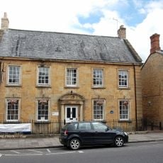
North Perrott Manor House, School in North Perrott, England

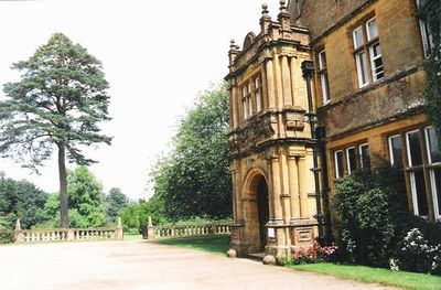
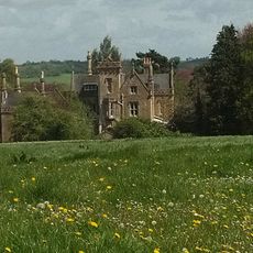
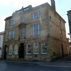
North Perrott Manor House is a two-storey stone building constructed in 1877 by architect Thomas Henry Wyatt, featuring an L-shaped plan, slate roof, and formal entrance porch with supporting columns. The estate includes an orangery with large windows, a two-storey stable block, a walled courtyard with decorative balusters, a small garden summerhouse, and a sunken garden with period seating and ornaments.

North Perrott Manor House was built in 1877 by architect Thomas Henry Wyatt for landowner P.M. Hoskyns and served as a family estate residence. During the Second World War it was used to house evacuated schoolchildren, and afterwards became Perrott Hill School, a role it continues today.

The property operates as a school and is not regularly open to visitors; access is typically available only during special heritage events. Prospective visitors should contact the school in advance or check for scheduled open days, as the grounds remain in active use for educational purposes.

The orangery roof sustained damage during the Second World War and was subsequently rebuilt, reflecting the building's layered history. Today the school has added modern features like a living sedum roof on its music building, creating a visible blend of historical architecture with contemporary needs.

The community of curious travelers

AroundUs brings together thousands of curated places, local tips, and hidden gems, enriched daily by 60,000 contributors worldwide.

Start exploring
Location
Architects
Thomas Henry Wyatt
GPS coordinates
50.88380,-2.75827
Latest update
February 9, 2026 07:44
Around this place
Church of St Bartholomew, Crewkerne
United Kingdom

Church of St Bartholomew, Crewkerne

2.4 km
Beacon Limestone Formation
United Kingdom

Beacon Limestone Formation

3.4 km
Christ Church, Crewkerne
United Kingdom

Christ Church, Crewkerne

2.5 km
Church of St Michael and All Angels
United Kingdom

Church of St Michael and All Angels

1.3 km
Church of St Martin, North Perrott
United Kingdom

Church of St Martin, North Perrott

599 m
Crewkerne Town Hall
United Kingdom

Crewkerne Town Hall

2.6 km
Church of Saint Margaret
United Kingdom

Church of Saint Margaret

3.5 km
Church of St Mary
United Kingdom

Church of St Mary

3 km
Church of St Leonard
United Kingdom

Church of St Leonard

2.1 km
George Hotel
United Kingdom

George Hotel

2.6 km
White Hart Hotel
United Kingdom

White Hart Hotel

2.6 km
Crewkerne War Memorial
United Kingdom

Crewkerne War Memorial

2.7 km
The Thatched Farmhouse
United Kingdom

The Thatched Farmhouse

2 km
Royal Oak Public House
United Kingdom

Royal Oak Public House

2.7 km
Milestone, Outside The Post Office And Stores
United Kingdom

Milestone, Outside The Post Office And Stores

1.3 km
Cottage, Coach House And Stable 15 Metres West Of The Old Rectory
United Kingdom

Cottage, Coach House And Stable 15 Metres West Of The Old Rectory

2.9 km
17 Market Street and attached railings
United Kingdom

17 Market Street and attached railings

2.6 km
Sarum
United Kingdom

Sarum

3 km
Milestone, 125 Metres South West Of Foxwell Lane Junction At Ngr St 47711220
United Kingdom

Milestone, 125 Metres South West Of Foxwell Lane Junction At Ngr St 47711220

2.7 km
Eastham's Gate Farmhouse
United Kingdom

Eastham's Gate Farmhouse

1.5 km
Road Bridge Over Mill Stream
United Kingdom

Road Bridge Over Mill Stream

3.6 km
Milestone At Ngr St 4550 1055, About 140 Metres South-West Of Eastham's Gate Farmhouse
United Kingdom

Milestone At Ngr St 4550 1055, About 140 Metres South-West Of Eastham's Gate Farmhouse

1.6 km
Moorlands
United Kingdom

Moorlands

3.5 km
National Westminster Bank
United Kingdom

National Westminster Bank

2.7 km
Direction stone at the junction of Foxwell Lane and the A30
United Kingdom

Direction stone at the junction of Foxwell Lane and the A30

2.9 km
Milestone, near Folly Farm
United Kingdom

Milestone, near Folly Farm

3.5 km
Lower Severalls Farmhouse
United Kingdom

Lower Severalls Farmhouse

1.8 km
Milestone, between South Perrot and Misterton
United Kingdom

Milestone, between South Perrot and Misterton

2.1 km
Show the full map
« North Perrott Manor House - School in North Perrott, England » is provided by Around Us (aroundus.com). Images and texts are derived from Wikimedia project under a Creative Commons license. You are allowed to copy, distribute, and modify copies of this page, under the conditions set by the license, as long as this note is clearly visible.

Discover hidden gems everywhere you go!

From secret cafés to breathtaking viewpoints, skip the crowded tourist spots and find places that match your style. Our app makes it easy with voice search, smart filtering, route optimization, and insider tips from travelers worldwide. Download now for the complete mobile experience.

Around Us App Screenshot

A unique approach to discovering new places

Le Figaro

All the places worth exploring

France Info

A tailor-made excursion in just a few clicks

20 Minutes

Around Us
Travel Guide & Maps
Download

Send to your phone

QR Code
1

Open the camera app on your mobile.

2

Point at the QR code with your camera. A notification will appear.

3

Tap the notification to open the link.