Enable Location

We need your location to show you interesting places around you

Discover nearby places

Find interesting locations and hidden gems around you

Precise directions

Get accurate directions and distances to places

Your location is never shared with other users. It's only used when you tap the location button.

Windmill Bridge

Log in to your account

Start exploring — it's free

Trusted by 62,169 travelers worldwide

Continue with Google
Continue with Apple
or

We will send you a code to connect

By continuing, you accept our Terms and Conditions and our Privacy Policy

Check your inbox

We've sent a pincode in your inbox. Please enter the code below.

Windmill Bridge, Road bridge and navigable aqueduct in Hanwell, England

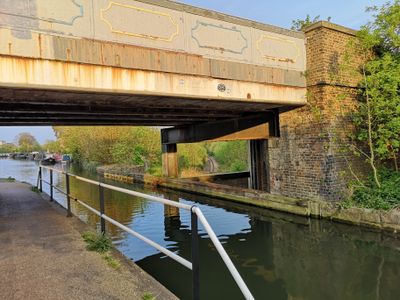
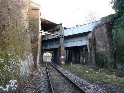
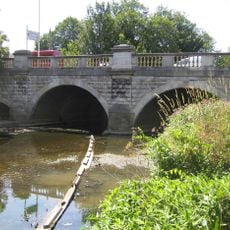
Windmill Bridge is a road bridge and navigable aqueduct in Hanwell with three stacked levels of transportation. The structure carries a road on top, a canal crossing in the middle, and a railway line at the bottom.

Isambard Kingdom Brunel designed this bridge in 1859 as his final railway project before his death that same year. The work displays his innovative approach to solving complex infrastructure demands.

The bridge represents Victorian engineering solutions that managed multiple transportation routes in a confined space. It shows how London's growing industry required the railway, canal, and road to work side by side.

Visitors can reach the bridge via Windmill Lane, while Three Bridge Park offers observation points for viewing the structure. The location provides good sightlines from several angles to examine the engineering details.

The cast iron aqueduct sections display original manufacturer details, including the maker's name and historic London address. These markings preserve a piece of Victorian trade history on the structure itself.

The community of curious travelers

AroundUs brings together thousands of curated places, local tips, and hidden gems, enriched daily by 60,000 contributors worldwide.

Start exploring
Inception
1859
GPS coordinates
51.50440,-0.35543
Latest update
December 8, 2025 19:51
Around this place
Osterley House
United Kingdom

Osterley House

1.7 km
Wharncliffe Viaduct
United Kingdom

Wharncliffe Viaduct

1.1 km
Southall Railway Centre
United Kingdom

Southall Railway Centre

1.1 km
City of Westminster Cemetery, Hanwell
United Kingdom

City of Westminster Cemetery, Hanwell

1.7 km
St. Mary's Church, Hanwell
United Kingdom

St. Mary's Church, Hanwell

1.2 km
St Anselm's Church, Southall
United Kingdom

St Anselm's Church, Southall

1.7 km
Church of St Thomas the Apostle
United Kingdom

Church of St Thomas the Apostle

1.8 km
The Hermitage
United Kingdom

The Hermitage

1.3 km
Palace Cinema
United Kingdom

Palace Cinema

1.6 km
Church of St Mellitus
United Kingdom

Church of St Mellitus

1.5 km
Church of St Mary
United Kingdom

Church of St Mary

1.3 km
Water Pump (On The South Side Of West Middlesex Golf Course, Nearly Opposite Lyndhurst Avenue)
United Kingdom

Water Pump (On The South Side Of West Middlesex Golf Course, Nearly Opposite Lyndhurst Avenue)

816 m
Walls, Gates, Sluices And Bridge At Lock (90)
United Kingdom

Walls, Gates, Sluices And Bridge At Lock (90)

594 m
The Plough Public House
United Kingdom

The Plough Public House

1.3 km
Southall War Memorial
United Kingdom

Southall War Memorial

1.8 km
Red Lion Public House
United Kingdom

Red Lion Public House

1.3 km
The Water Tower
United Kingdom

The Water Tower

1.8 km
Roman Bridge
United Kingdom

Roman Bridge

664 m
Hanwell Bridge
United Kingdom

Hanwell Bridge

970 m
Stable Block At Brent Lodge Park
United Kingdom

Stable Block At Brent Lodge Park

1.1 km
Former Norwood Free School
United Kingdom

Former Norwood Free School

1.2 km
The Temple In Osterley Park
United Kingdom

The Temple In Osterley Park

1.6 km
Main Up Side Building and Downside Island Platform at Hanwell Station
United Kingdom

Main Up Side Building and Downside Island Platform at Hanwell Station

1.4 km
Southall Manor House
United Kingdom

Southall Manor House

1.8 km
Hanwell flight of locks and brick boundary wall of St Bernard's Hospital
United Kingdom

Hanwell flight of locks and brick boundary wall of St Bernard's Hospital

509 m
Osterley House Stables
United Kingdom

Osterley House Stables

1.6 km
Entrance Archway And 2 Lodges, (One Each Side Of Entrance) To St Bernard's Hospital
United Kingdom

Entrance Archway And 2 Lodges, (One Each Side Of Entrance) To St Bernard's Hospital

634 m
Aviary or Little Orangerey in Osterley Park
United Kingdom

Aviary or Little Orangerey in Osterley Park

1.5 km
Show the full map
« Windmill Bridge - Road bridge and navigable aqueduct in Hanwell, England » is provided by Around Us (aroundus.com). Images and texts are derived from Wikimedia project under a Creative Commons license. You are allowed to copy, distribute, and modify copies of this page, under the conditions set by the license, as long as this note is clearly visible.

Discover hidden gems everywhere you go!

From secret cafés to breathtaking viewpoints, skip the crowded tourist spots and find places that match your style. Our app makes it easy with voice search, smart filtering, route optimization, and insider tips from travelers worldwide. Download now for the complete mobile experience.

Around Us App Screenshot

A unique approach to discovering new places

Le Figaro

All the places worth exploring

France Info

A tailor-made excursion in just a few clicks

20 Minutes

Around Us
Travel Guide & Maps
Download

Send to your phone

QR Code
1

Open the camera app on your mobile.

2

Point at the QR code with your camera. A notification will appear.

3

Tap the notification to open the link.