Enable Location

We need your location to show you interesting places around you

Discover nearby places

Find interesting locations and hidden gems around you

Precise directions

Get accurate directions and distances to places

Your location is never shared with other users. It's only used when you tap the location button.

Lilla Cross

Log in to your account

Start exploring — it's free

Trusted by 63,421 travelers worldwide

Continue with Google
Continue with Apple
or

We will send you a code to connect

By continuing, you accept our Terms and Conditions and our Privacy Policy

Check your inbox

We've sent a pincode in your inbox. Please enter the code below.

Discussion Reviews 1 Photos
3.1k Popularity

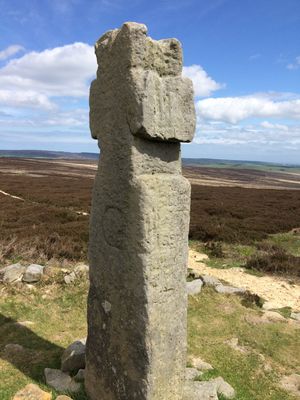
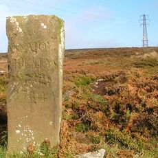
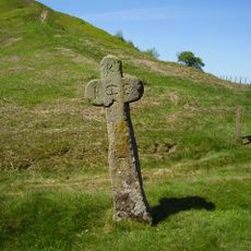
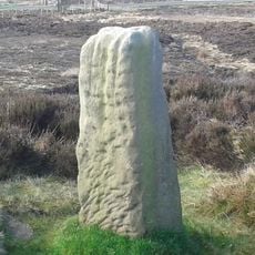
Lilla Cross, Medieval stone cross on Fylingdales Moor, England

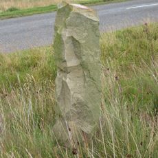
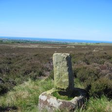
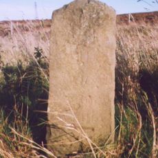
Lilla Cross is a medieval stone cross on Fylingdales Moor standing about 10 feet high atop an ancient mound. Its surface bears carved letters including a prominent 'C' and thin lines marking out a cross shape.

The cross dates to medieval times and was temporarily moved to a nearby location near Goathland in 1952. It returned to its original site in 1962.

The monument commemorates Lilla, chief minister to King Edwin of Northumbria, who gave his life protecting the king from assassination. Local people in the surrounding villages know this story and regard the site as a symbol of loyalty and sacrifice.

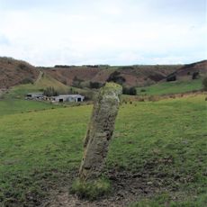
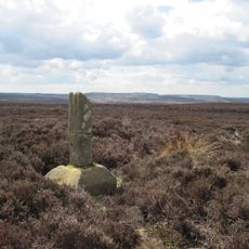
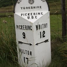
The cross can be reached by following two main moorland footpaths that intersect at this location between Pickering and Whitby. It helps to wear sturdy footwear since the moorland terrain is uneven and often damp.

Excavations in the 1920s around the ancient mound beneath the cross uncovered jewelry from the mid-ninth century. These findings reveal that the location held importance long before the cross was erected.

The community of curious travelers

AroundUs brings together thousands of curated places, local tips, and hidden gems, enriched daily by 60,000 contributors worldwide.

Start exploring
Location
Location
Location
GPS coordinates
54.37590,-0.63256
Latest update
December 12, 2025 09:08
Around this place
RAF Fylingdales
United Kingdom

RAF Fylingdales

2.9 km
Blakey Topping standing stones
United Kingdom

Blakey Topping standing stones

5.6 km
The Pigsty
United Kingdom

The Pigsty

7.2 km
Simon Howe
United Kingdom

Simon Howe

5.9 km
Church of St Mary Entrance Steps And Attached Handrail
United Kingdom

Church of St Mary Entrance Steps And Attached Handrail

6.5 km
The Mallan Hotel
United Kingdom

The Mallan Hotel

6.5 km
Goathland War Memorial
United Kingdom

Goathland War Memorial

6.3 km
Boundary Stone
United Kingdom

Boundary Stone

5.5 km
Line Of Boundary Stones Between Civil Parishes Of Sneaton And Eskdaleside Cum Ugglebarnby
United Kingdom

Line Of Boundary Stones Between Civil Parishes Of Sneaton And Eskdaleside Cum Ugglebarnby

4.9 km
John Cross
United Kingdom

John Cross

4.2 km
North York Moors Railway Goathland Station
United Kingdom

North York Moors Railway Goathland Station

5.9 km
North York Moors Railway Footbridge Linking Plaforms At Goathland Station
United Kingdom

North York Moors Railway Footbridge Linking Plaforms At Goathland Station

5.8 km
Stones
United Kingdom

Stones

5.9 km
North York Moors Railway Water Column At Goathland Station
United Kingdom

North York Moors Railway Water Column At Goathland Station

5.9 km
'Breckon Howe' round barrow, Sleights Moor
United Kingdom

'Breckon Howe' round barrow, Sleights Moor

5.9 km
Malo Cross
United Kingdom

Malo Cross

4.4 km
Stones
United Kingdom

Stones

5.4 km
Boundary Stone
United Kingdom

Boundary Stone

4.8 km
Brereton Corner
United Kingdom

Brereton Corner

6.3 km
Ann's Cross
United Kingdom

Ann's Cross

1.9 km
North York Moors Railway Workshop And Water Tank At Goathland Station
United Kingdom

North York Moors Railway Workshop And Water Tank At Goathland Station

5.8 km
Waymarker
United Kingdom

Waymarker

7.2 km
Waymarker
United Kingdom

Waymarker

7.2 km
Breckon Howe Boundary Stone Between Parishes Od Eskdaleside Cum Ugglebarnsby And Goathland
United Kingdom

Breckon Howe Boundary Stone Between Parishes Od Eskdaleside Cum Ugglebarnsby And Goathland

5.9 km
Wayside cross called Postgate Cross on Graystone Hills 700m NNE of Sneaton Corner
United Kingdom

Wayside cross called Postgate Cross on Graystone Hills 700m NNE of Sneaton Corner

6.4 km
York Cross wayside cross, 700m north east of Foster Howes on Sneaton High Moor
United Kingdom

York Cross wayside cross, 700m north east of Foster Howes on Sneaton High Moor

3 km
Milestone, just S of entrance to Fylingdales Early Warning Station
United Kingdom

Milestone, just S of entrance to Fylingdales Early Warning Station

3.9 km
Milestone, carved stone post, near entrance to Barr Farm
United Kingdom

Milestone, carved stone post, near entrance to Barr Farm

5.1 km
Show the full map
Reviews
Share your experience

No review yet

Discussions
Start a discussion...

No discussion yet

« Lilla Cross - Medieval stone cross on Fylingdales Moor, England » is provided by Around Us (aroundus.com). Images and texts are derived from Wikimedia project under a Creative Commons license. You are allowed to copy, distribute, and modify copies of this page, under the conditions set by the license, as long as this note is clearly visible.

Discover hidden gems everywhere you go!

From secret cafés to breathtaking viewpoints, skip the crowded tourist spots and find places that match your style. Our app makes it easy with voice search, smart filtering, route optimization, and insider tips from travelers worldwide. Download now for the complete mobile experience.

Around Us App Screenshot

A unique approach to discovering new places

Le Figaro

All the places worth exploring

France Info

A tailor-made excursion in just a few clicks

20 Minutes

Around Us
Travel Guide & Maps
Download

Send to your phone

QR Code
1

Open the camera app on your mobile.

2

Point at the QR code with your camera. A notification will appear.

3

Tap the notification to open the link.