Enable Location

We need your location to show you interesting places around you

Discover nearby places

Find interesting locations and hidden gems around you

Precise directions

Get accurate directions and distances to places

Your location is never shared with other users. It's only used when you tap the location button.

RAF Fylingdales

Log in to your account

Start exploring — it's free

Trusted by 61,760 travelers worldwide

Continue with Google
Continue with Apple
or

We will send you a code to connect

By continuing, you accept our Terms and Conditions and our Privacy Policy

Check your inbox

We've sent a pincode in your inbox. Please enter the code below.

RAF Fylingdales, Military radar station in North Yorkshire, England

Description

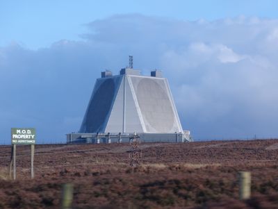
RAF Fylingdales sits high on the North York Moors with its large pyramid-shaped radar buildings scanning the skies and space around the clock, surrounded by green hills and quiet countryside that creates a calm but purposeful atmosphere.

History

The station was built in the early 1960s during the Cold War with three large dome-shaped radars that looked like golf balls, and over the years it has evolved into a modern facility with sleek systems that track satellites and watch for missile threats.

Culture

Staff here work together in long shifts watching thousands of objects orbiting Earth, and they describe their job as protecting communication networks and preventing space debris from causing damage, which makes them feel proud to be part of this quiet guardian mission.

Practical

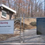
The station is not open to visitors, but you can see the radar structures from nearby walking paths and the small village of Pickering offers cozy cafes and shops where locals often talk about living near this important defense site.

Did you know?

The radar here can detect objects thousands of miles away in space using tiny electronic parts that direct beams precisely, and during special occasions the Red Arrows fly overhead to celebrate the station's role in keeping the country safe from threats beyond the clouds.

Location
Operator
Royal Air Force
Part of
Ballistic Missile Early Warning System
Address
Pickering
GPS coordinates
54.36160,-0.66970
Latest update
December 12, 2025 17:59

AroundUs brings together thousands of curated places, local tips, and hidden gems, enriched daily by 60,000 contributors worldwide. Discover all places nearby (North Yorkshire).

Secret military sites and underground facilities around the world

This collection brings together underground military sites, strategic bunkers, and highly secured installations across the world. Many of these places were built during the Cold War, when nuclear threats pushed governments to create protected command centers deep under mountains or in remote areas....

Around this place
Lilla Cross
United Kingdom

Lilla Cross

2.9 km
Blakey Topping standing stones
United Kingdom

Blakey Topping standing stones

3.7 km
Simon Howe
United Kingdom

Simon Howe

3.7 km
United Kingdom

Moorgates Cottages And Attached Yard Walls

3.2 km
United Kingdom

Cross dyke on Saltergate Brow, 750m south east of Barr Farm

2.8 km
United Kingdom

Ann's Cross wayside cross on bowl barrow 800m south east of Foster Howes

3.4 km
United Kingdom

Cross ridge dyke known as Gallows Dike and three round barrows 330m south west of Glebe Farm

3.4 km
United Kingdom

Round barrow 660m south west of Glebe Farm

3.6 km
Ann's Cross
United Kingdom

Ann's Cross

3.4 km
Malo Cross
United Kingdom

Malo Cross

2.1 km
United Kingdom

Low Woof Howe round barrow

2.8 km
United Kingdom

Round barrow on Derwent Head Rigg, 200m east of High Woof Howe

2.9 km
United Kingdom

Round barrow on Derwent Head Rigg, 145m east of High Woof Howe

2.9 km
United Kingdom

Cairnfield and field systems on Saltergate Moor, immediately north of Nab Farm

1.5 km
Milestone, just S of entrance to Fylingdales Early Warning Station
United Kingdom

Milestone, just S of entrance to Fylingdales Early Warning Station

1.1 km
United Kingdom

Bowl barrow 30m north of Lilla Cross

2.9 km
United Kingdom

Eller Beck Bridge

1.5 km
United Kingdom

Widow Howe: two round barrows on Widow Howe Rigg

3 km
United Kingdom

High Woof Howe round barrow at Derwent Head Rigg

2.7 km
Milestone, carved stone post, near entrance to Barr Farm
United Kingdom

Milestone, carved stone post, near entrance to Barr Farm

2.3 km
Milestone, cast iron post, near entrance to Barr Farm
United Kingdom

Milestone, cast iron post, near entrance to Barr Farm

2.3 km
United Kingdom

Field system and cairnfield on Lockton High Moor, 1km NNE of Needle Point

2.2 km
United Kingdom

Louven Howe round barrow

3 km
United Kingdom

Moorgates Cattle Arch

3.1 km
United Kingdom

Bridge Over A Tributary Of The Eller Beck

1.4 km
United Kingdom

Needle Point

3 km
United Kingdom

Waterfall

2.9 km
United Kingdom

Waterfall

3.6 km
Show the full map
« RAF Fylingdales - Military radar station in North Yorkshire, England » is provided by Around Us (aroundus.com). Images and texts are derived from Wikimedia project under a Creative Commons license. You are allowed to copy, distribute, and modify copies of this page, under the conditions set by the license, as long as this note is clearly visible.

Discover hidden gems everywhere you go!

From secret cafés to breathtaking viewpoints, skip the crowded tourist spots and find places that match your style. Our app makes it easy with voice search, smart filtering, route optimization, and insider tips from travelers worldwide. Download now for the complete mobile experience.

Around Us App Screenshot

A unique approach to discovering new places

Le Figaro

All the places worth exploring

France Info

A tailor-made excursion in just a few clicks

20 Minutes

Around Us
Travel Guide & Maps
Download

Send to your phone

QR Code
1

Open the camera app on your mobile.

2

Point at the QR code with your camera. A notification will appear.

3

Tap the notification to open the link.