Enable Location

We need your location to show you interesting places around you

Discover nearby places

Find interesting locations and hidden gems around you

Precise directions

Get accurate directions and distances to places

Your location is never shared with other users. It's only used when you tap the location button.

St Bridget's Church

Log in to your account

Start exploring — it's free

Trusted by 62,097 travelers worldwide

Continue with Google
Continue with Apple
or

We will send you a code to connect

By continuing, you accept our Terms and Conditions and our Privacy Policy

Check your inbox

We've sent a pincode in your inbox. Please enter the code below.

St Bridget's Church

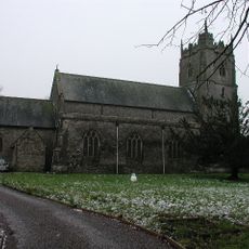
St Bridget's Church, Medieval church in St. Brides Wentloog, Wales

St Bridget's Church is a medieval place of worship near Newport featuring a buttressed western tower topped with battlements in the perpendicular style. The tower holds six bells, with four cast in 1734 that bear inscriptions.

The building underwent major reconstruction in the 15th century while keeping parts of an earlier 14th-century chapel. This rebuilding shaped the structure visitors see today.

A plaque inside the porch marks the water level from the 1607 Bristol Channel floods, preserving memory of a disaster that shaped the community. This visible reminder helps visitors understand how the local landscape and people adapted to living with water.

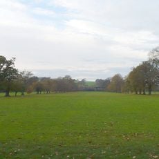
The church serves as an active place of worship with regular services and is part of the Mountain and Marsh Ministry Area network. The surrounding flat landscape with drainage channels is typical for the area and poses no barriers to visiting.

The church sits at only 6 meters (20 feet) above sea level surrounded by characteristic drainage ditches called reens that define the Wentloog Level landscape. This low position and the distinctive waterways reveal how the settlement adapted to the wetland terrain.

The community of curious travelers

AroundUs brings together thousands of curated places, local tips, and hidden gems, enriched daily by 60,000 contributors worldwide.

Start exploring
Location
Elevation above the sea
6 m
GPS coordinates
51.53510,-3.02163
Latest update
December 12, 2025 12:00
Around this place
Newport Transporter Bridge
United Kingdom

Newport Transporter Bridge

4.7 km
Tredegar House
United Kingdom

Tredegar House

3 km
Cardiff Capital Region
United Kingdom

Cardiff Capital Region

3.4 km
Inmos microprocessor factory
United Kingdom

Inmos microprocessor factory

3.4 km
West Usk Lighthouse
United Kingdom

West Usk Lighthouse

2 km
Tredegar House Country Park
United Kingdom

Tredegar House Country Park

3.3 km
Phyllis Maud Performance Space
United Kingdom

Phyllis Maud Performance Space

4 km
St Peter's Church
United Kingdom

St Peter's Church

3.3 km
Stable Block Including Orangery
United Kingdom

Stable Block Including Orangery

3 km
East Usk Lighthouse
United Kingdom

East Usk Lighthouse

3.8 km
Tredegar Fort
United Kingdom

Tredegar Fort

4.6 km
St Mary's Church
United Kingdom

St Mary's Church

3.1 km
The Coach and Horses PH
United Kingdom

The Coach and Horses PH

4.1 km
Brewhouse
United Kingdom

Brewhouse

2.9 km
Waterloo Hotel
United Kingdom

Waterloo Hotel

4.6 km
Monument to Sir Briggs
United Kingdom

Monument to Sir Briggs

2.9 km
Edney Gates, Inc Flanking Screen And Attached Walls With Opposing Gates To S End Of Middle Court
United Kingdom

Edney Gates, Inc Flanking Screen And Attached Walls With Opposing Gates To S End Of Middle Court

3 km
Former Laundry and Dairy to NE of Great Barn
United Kingdom

Former Laundry and Dairy to NE of Great Barn

3 km
Great Barn
United Kingdom

Great Barn

2.9 km
Footbridge at former Tredegar Park Golf Course
United Kingdom

Footbridge at former Tredegar Park Golf Course

4.4 km
Ruperra Gates to NE of Tredegar House
United Kingdom

Ruperra Gates to NE of Tredegar House

3 km
Entrance Gateway at Faendre Hall
United Kingdom

Entrance Gateway at Faendre Hall

4.8 km
Boundary Walls To Orangery Garden And Cedar Garden Including Three Sets Of Gatepiers
United Kingdom

Boundary Walls To Orangery Garden And Cedar Garden Including Three Sets Of Gatepiers

3 km
Bothy and Potting Shed to the West of Bryans Building
United Kingdom

Bothy and Potting Shed to the West of Bryans Building

2.9 km
The Mill including attached Stable to the South
United Kingdom

The Mill including attached Stable to the South

2.9 km
Garden walls to SE of Cedar Garden, inc gate piers, gates and flanking workshops
United Kingdom

Garden walls to SE of Cedar Garden, inc gate piers, gates and flanking workshops

2.8 km
Pair of lodges, gates and piers with flanking walls to NW of Tredegar House
United Kingdom

Pair of lodges, gates and piers with flanking walls to NW of Tredegar House

3.6 km
Providence
United Kingdom

Providence

611 m
Show the full map
« St Bridget's Church - Medieval church in St. Brides Wentloog, Wales » is provided by Around Us (aroundus.com). Images and texts are derived from Wikimedia project under a Creative Commons license. You are allowed to copy, distribute, and modify copies of this page, under the conditions set by the license, as long as this note is clearly visible.

Discover hidden gems everywhere you go!

From secret cafés to breathtaking viewpoints, skip the crowded tourist spots and find places that match your style. Our app makes it easy with voice search, smart filtering, route optimization, and insider tips from travelers worldwide. Download now for the complete mobile experience.

Around Us App Screenshot

A unique approach to discovering new places

Le Figaro

All the places worth exploring

France Info

A tailor-made excursion in just a few clicks

20 Minutes

Around Us
Travel Guide & Maps
Download

Send to your phone

QR Code
1

Open the camera app on your mobile.

2

Point at the QR code with your camera. A notification will appear.

3

Tap the notification to open the link.