Enable Location

We need your location to show you interesting places around you

Discover nearby places

Find interesting locations and hidden gems around you

Precise directions

Get accurate directions and distances to places

Your location is never shared with other users. It's only used when you tap the location button.

Plas Rhianfa

Log in to your account

Start exploring — it's free

Trusted by 61,910 travelers worldwide

Continue with Google
Continue with Apple
or

We will send you a code to connect

By continuing, you accept our Terms and Conditions and our Privacy Policy

Check your inbox

We've sent a pincode in your inbox. Please enter the code below.

Plas Rhianfa

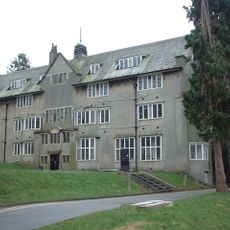
Plas Rhianfa, Grade II* listed building in Cwm Cadnant, United Kingdom

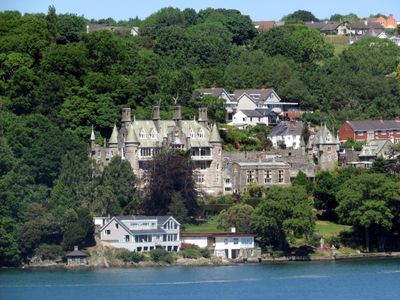
Plas Rhianfa is a Victorian country house on the banks of the Menai Strait, featuring distinctive round towers with conical roofs. An upper-level gallery connects the different sections, creating a distinctive profile when viewed from the water.

Construction of this country house was completed in 1850 following designs by Liverpool architect Charles Verelst, who drew inspiration from Loire Valley sketches. The design reflected the Victorian fashion for adapting French architectural styles to the Welsh landscape.

The entrance displays intricate ironwork and bears an inscription from Psalm 90, showing how religious faith was woven into Victorian design. Such details reflect the builder's values and their desire to express them through the home's physical form.

The house sits on a waterfront setting with views across the strait and surrounding hills, offering direct access to the landscape. The structure spreads across multiple levels, and visitors can explore the terraced gardens throughout the grounds.

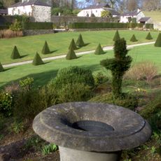
The seaside garden grows Mediterranean plants like palms, cordylines, and myrtle that seem unexpected in this region. The sheltered waterside location creates a warm microclimate that allows these warm-weather plants to thrive.

The community of curious travelers

AroundUs brings together thousands of curated places, local tips, and hidden gems, enriched daily by 60,000 contributors worldwide.

Start exploring
Location
Elevation above the sea
23.1 m
GPS coordinates
53.23820,-4.14396
Latest update
December 11, 2025 11:09
Around this place
Plas Cadnant
United Kingdom

Plas Cadnant

1.3 km
Coed Cadnant
United Kingdom

Coed Cadnant

1.1 km
Church of St Tegfan
United Kingdom

Church of St Tegfan

1.2 km
Tŵr-Gwyn Chapel
United Kingdom

Tŵr-Gwyn Chapel

1.4 km
University Anglican Chaplaincy Centre
United Kingdom

University Anglican Chaplaincy Centre

1.2 km
Gate Piers to Grounds of Normal College Hostels,Menai Road
United Kingdom

Gate Piers to Grounds of Normal College Hostels,Menai Road

1.3 km
Bangor Normal College
United Kingdom

Bangor Normal College

1.3 km
Main Entrance to Normal College & attached Boundary Walls & Entrance to Athrolys and Neuadd John Phi
United Kingdom

Main Entrance to Normal College & attached Boundary Walls & Entrance to Athrolys and Neuadd John Phi

1.3 km
Neuadd Fôn
United Kingdom

Neuadd Fôn

1.2 km
Neuadd Dyfrdwy (Normal College) College Road
United Kingdom

Neuadd Dyfrdwy (Normal College) College Road

1.2 km
Poplars
United Kingdom

Poplars

1.4 km
Neuadd Eryri (Normal College) College Road
United Kingdom

Neuadd Eryri (Normal College) College Road

1.2 km
Former Normal College Gymnasium (Gwynedd Technical College, Art & Design Section) College Road
United Kingdom

Former Normal College Gymnasium (Gwynedd Technical College, Art & Design Section) College Road

1.3 km
John Phillips Hall
United Kingdom

John Phillips Hall

1.2 km
Princes Road Pentecostal Church
United Kingdom

Princes Road Pentecostal Church

1.1 km
Bangor Music School
United Kingdom

Bangor Music School

1.3 km
Bryn Menai
United Kingdom

Bryn Menai

1.1 km
Bangor Gorsedd Circle
United Kingdom

Bangor Gorsedd Circle

1 km
Pillar Box On Pavement to W.of Music Department Building,College Road
United Kingdom

Pillar Box On Pavement to W.of Music Department Building,College Road

1.3 km
Bryn Afon (Centre For Social Policy Research and Development) College Lane
United Kingdom

Bryn Afon (Centre For Social Policy Research and Development) College Lane

1.3 km
No.2 Bron Menai,Menai Road
United Kingdom

No.2 Bron Menai,Menai Road

1.3 km
No.1 Bron Menai, Menai Road
United Kingdom

No.1 Bron Menai, Menai Road

1.3 km
Neuadd Alun (Normal College) College Road
United Kingdom

Neuadd Alun (Normal College) College Road

1.3 km
Princes Road English Presbyterian Church
United Kingdom

Princes Road English Presbyterian Church

1.3 km
The Normal College (Original Building) Menai Road
United Kingdom

The Normal College (Original Building) Menai Road

1.3 km
Neuadd Ogwen
United Kingdom

Neuadd Ogwen

1.2 km
Penbre
United Kingdom

Penbre

1.3 km
Wartski memorial plaque
United Kingdom

Wartski memorial plaque

1.1 km
Show the full map
« Plas Rhianfa - Grade II* listed building in Cwm Cadnant, United Kingdom » is provided by Around Us (aroundus.com). Images and texts are derived from Wikimedia project under a Creative Commons license. You are allowed to copy, distribute, and modify copies of this page, under the conditions set by the license, as long as this note is clearly visible.

Discover hidden gems everywhere you go!

From secret cafés to breathtaking viewpoints, skip the crowded tourist spots and find places that match your style. Our app makes it easy with voice search, smart filtering, route optimization, and insider tips from travelers worldwide. Download now for the complete mobile experience.

Around Us App Screenshot

A unique approach to discovering new places

Le Figaro

All the places worth exploring

France Info

A tailor-made excursion in just a few clicks

20 Minutes

Around Us
Travel Guide & Maps
Download

Send to your phone

QR Code
1

Open the camera app on your mobile.

2

Point at the QR code with your camera. A notification will appear.

3

Tap the notification to open the link.