
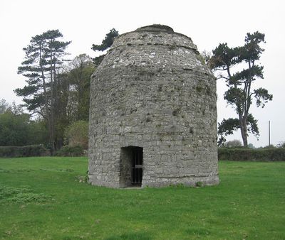
Llantwit Major Dovecote, listed building in Llantwit Major, Vale of Glamorgan, Wales
Location: Llantwit Major
Elevation above the sea: 44.4 m
GPS coordinates: 51.40700,-3.48872
Latest update: March 22, 2025 07:25

St Illtyd's Church, Llantwit Major
132 m
Dimlands
866 m
Llantwit Major Town Hall
216 m
Well opposite Downcross Farm
537 m
Bethel Baptist Chapel
349 m
Tudor Tavern P.H.
205 m
The Old Police Station
49 m
Old White Hart P.H.
203 m
Old Swan Inn
239 m
Llantwit Major War Memorial
210 m
West Farmhouse
298 m
Telephone Call-Box outside Old White Hart P.H.
215 m
Tabernacle Calvinistic Methodist Chapel
182 m
Downcross Farmhouse including front garden walls
555 m
Cross in Churchyard of Church of St. Illtud
122 m
Plymouth House
223 m
Old Place (or Llantwit Major Castle)
425 m
Court House
392 m
Ty-mawr
637 m
Outhouse at Sunny Bank
517 m
Swimbridge Farmhouse with attached garden walls
302 m
Corner House
445 m
Former Chantry Priest's House
107 m
Chantry House
81 m
The Old School, including attached walling
214 m
The Gatehouse (porter's Room)
57 m
Quaintways, with attached garden wall
268 m
The Old House
468 mReviews
Visited this place? Tap the stars to rate it and share your experience / photos with the community! Try now! You can cancel it anytime.
Discover hidden gems everywhere you go!
From secret cafés to breathtaking viewpoints, skip the crowded tourist spots and find places that match your style. Our app makes it easy with voice search, smart filtering, route optimization, and insider tips from travelers worldwide. Download now for the complete mobile experience.

A unique approach to discovering new places❞
— Le Figaro
All the places worth exploring❞
— France Info
A tailor-made excursion in just a few clicks❞
— 20 Minutes