
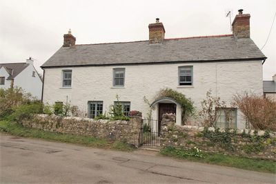
Downcross Farmhouse including front garden walls, About 100m south of Great House.
Location: Llantwit Major
Elevation above the sea: 47.5 m
GPS coordinates: 51.41187,-3.48704
Latest update: March 16, 2025 18:50

St Illtyd's Church, Llantwit Major
433 m
Dimlands
1.2 km
Llantwit Major Town Hall
436 m
Well opposite Downcross Farm
30 m
Bethel Baptist Chapel
324 m
Tudor Tavern P.H.
422 m
The Old Police Station
508 m
Old White Hart P.H.
394 m
Old Swan Inn
404 m
Llantwit Major War Memorial
399 m
Telephone Call-Box outside Old White Hart P.H.
389 m
Cross in Churchyard of Church of St. Illtud
447 m
Court House
272 m
Tabernacle Calvinistic Methodist Chapel
567 m
West Farmhouse
279 m
Plymouth House
350 m
Old Place (or Llantwit Major Castle)
138 m
Outhouse at Sunny Bank
75 m
Ty-mawr
82 m
Swimbridge Farmhouse with attached garden walls
256 m
The Gatehouse (porter's Room)
498 m
Corner House
134 m
Footbridge over brook at West entrance to churchyard of Church of St Illtud
453 m
The Old School, including attached walling
351 m
Llantwit Major Dovecote
555 m
Former Chantry Priest's House
463 m
Quaintways, with attached garden wall
615 m
Chantry House
491 mReviews
Visited this place? Tap the stars to rate it and share your experience / photos with the community! Try now! You can cancel it anytime.
Discover hidden gems everywhere you go!
From secret cafés to breathtaking viewpoints, skip the crowded tourist spots and find places that match your style. Our app makes it easy with voice search, smart filtering, route optimization, and insider tips from travelers worldwide. Download now for the complete mobile experience.

A unique approach to discovering new places❞
— Le Figaro
All the places worth exploring❞
— France Info
A tailor-made excursion in just a few clicks❞
— 20 Minutes