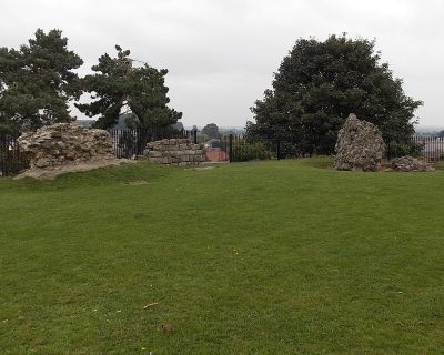
Oswestry Castle, Motte-and-bailey castle ruins in Oswestry, England
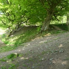
Oswestry Castle is a motte-and-bailey fortress in the English town of Oswestry featuring a mound rising approximately 12 meters high with remains of a stone keep from medieval times. The earthworks and stone foundations form a clear outline of how the Norman stronghold once protected the surrounding landscape.
The site was founded by Rainald, who held the position of Sheriff of Shropshire, and first appears in records around 1086 under the name Castelle Lurve. It stood at a crossroads that gave control over the surrounding lands and trade routes.
The castle grounds serve as an educational resource for local schools, enabling students to learn about medieval architecture and defensive structures in England.
The ruins are accessible through public pathways near the center of Oswestry and other local heritage sites in the area. Visiting during dry weather makes it easier to explore the grassy slopes without slipping or getting muddy.
An inventory from 1398 lists specific rooms inside the fortress including a hall, kitchen, larder, and a chapel dedicated to Saint Nicholas. This detailed record offers rare insight into the daily life and religious practices of those living within the walls.
Location: Oswestry Civil Parish
GPS coordinates: 52.86110,-3.05525
Latest update: December 8, 2025 21:06
Old Oswestry
1.3 km
Brogyntyn
1.7 km
The Guildhall, Oswestry
44 m
Cambrian Railways works
548 m
Church of St Oswald
478 m
Church of Holy Trinity
466 m
Hermon Chapel
72 m
Llwyd Mansion
191 m
Bennion/Lewis Memorial Abutting East End Of Vestry Of Church Of St Oswald
486 m
Cambrian Railways Museum
301 m
Oswestry Library
81 m
War Memorial to the Staff of the Cambrian Railways
386 m
War Memorial
376 m
Offa's Dyke: section one mile 1000yds (2520m) long, N of Llanforda Mill
3.6 km
Oswestry South Signal Box
331 m
2, Lower Brook Street
564 m
Milestone at NGR SJ 29997 31019
1.5 km
Milestone At Ngr Sj 3020 3259
3 km
Ha-Ha To South And West Of Sweeney Hall Incorporating Non Conformist Cemetery At South West Corner
3.3 km
Boundary Stone Built Into Wall At Ngr Sj 2817 3029
1 km
Outbuilding And Attached Brick Wall In Courtyard To Rear Of Sweeney Hall
3.3 km
Lamp Approximately 4 Metres West Of Tower Of Church Of St Oswald
495 m
Milestone At Ngr Sj 3154 2792
3.1 km
Sundial Approximately 30 Metres South West Of Church Of St Oswald
525 m
Barn Approximately 40 Metres East Of Sweeney Hall
3.3 km
Fowl House/Dovecote Attached To North East Corner Of Sweeney Hall
3.3 km
Milestone, Oswestry Hill Fort; N of Oldport
1.5 km
Milestone, The Mount, Oswestry
1.5 kmVisited this place? Tap the stars to rate it and share your experience / photos with the community! Try now! You can cancel it anytime.
Discover hidden gems everywhere you go!
From secret cafés to breathtaking viewpoints, skip the crowded tourist spots and find places that match your style. Our app makes it easy with voice search, smart filtering, route optimization, and insider tips from travelers worldwide. Download now for the complete mobile experience.
A unique approach to discovering new places❞
— Le Figaro
All the places worth exploring❞
— France Info
A tailor-made excursion in just a few clicks❞
— 20 Minutes