Old Oswestry, Iron Age hillfort in Shropshire, England
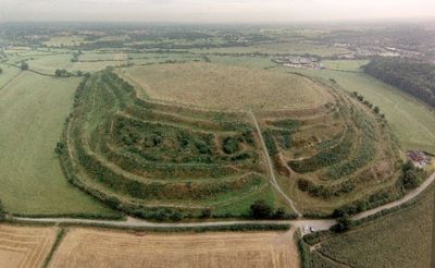
Old Oswestry is an Iron Age fortification in Shropshire featuring multiple defensive earthworks with steep banks and deep ditches spread across the landscape near the Welsh border. The site displays clearly visible defensive lines arranged in concentric patterns, showing different building phases across its structure.
The fortification was built between the 9th and 1st centuries BC and went through four major construction phases with progressively stronger defenses. Each phase added more substantial earthworks and ditches, reflecting its growing importance to ancient inhabitants.
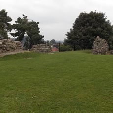
Local traditions connect this place to Arthurian legends, particularly identifying it as the birthplace of Queen Guinevere. These stories have shaped how people in the area understand and relate to the site.
Access to the site is through a dedicated parking area on Gatacre Avenue, roughly 400 meters from the entrance. The uneven terrain of the earthworks requires sturdy footwear and some physical effort to explore properly.
During World War I, the Canadian Expeditionary Force used this ancient fortification for military training, leaving behind visible traces of practice trenches. This layering of centuries is especially noticeable on the southern side of the site.
Location: Selattyn and Gobowen
Part of: Old Oswestry hillfort, and two adjacent sections of Wat's Dyke
Website: https://english-heritage.org.uk/visit/places/old-oswestry-hillfort
GPS coordinates: 52.87200,-3.04780
Latest update: December 9, 2025 18:45
Brogyntyn
1.6 km
Oswestry Castle
1.3 km
The Guildhall, Oswestry
1.3 km
Cambrian Railways works
1 km
Whittington Castle
3 km
Church of St Oswald
1.8 km
Church of Holy Trinity
1.6 km
Church of St John the Baptist
3 km
Hermon Chapel
1.3 km
Llwyd Mansion
1.5 km
Bennion/Lewis Memorial Abutting East End Of Vestry Of Church Of St Oswald
1.8 km
Cambrian Railways Museum
1.3 km
Oswestry Library
1.4 km
War Memorial to the Staff of the Cambrian Railways
1.7 km
War Memorial
1.7 km
Gobowen War Memorial
2.6 km
Oswestry South Signal Box
1.3 km
Milestone At Ngr Sj 3020 3259
1.7 km
2, Lower Brook Street
1.9 km
Boundary Stone Built Into Wall At Ngr Sj 2817 3029
1.6 km
Milestone at NGR SJ 29997 31019
427 m
Milestone At Ngr Sj 3010 3416
3.2 km
Milestone At Ngr Sj 3154 2792
3.7 km
Sundial Approximately 30 Metres South West Of Church Of St Oswald
1.8 km
Lamp Approximately 4 Metres West Of Tower Of Church Of St Oswald
1.8 km
Milestone, Selattyn Hill
3.7 km
Milestone, Oswestry Hill Fort; N of Oldport
426 m
Milestone, The Mount, Oswestry
1.9 kmVisited this place? Tap the stars to rate it and share your experience / photos with the community! Try now! You can cancel it anytime.
Discover hidden gems everywhere you go!
From secret cafés to breathtaking viewpoints, skip the crowded tourist spots and find places that match your style. Our app makes it easy with voice search, smart filtering, route optimization, and insider tips from travelers worldwide. Download now for the complete mobile experience.
A unique approach to discovering new places❞
— Le Figaro
All the places worth exploring❞
— France Info
A tailor-made excursion in just a few clicks❞
— 20 Minutes