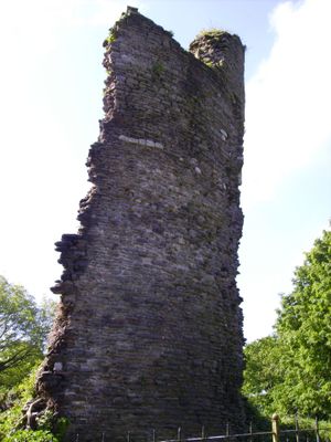
Llantrisant Castle, Medieval castle ruins in Llantrisant, Wales
Llantrisant Castle is a ruined fortress situated on a flat-topped ridge that overlooks the surrounding valleys. The most distinctive feature is a circular tower known as the Raven, with surviving sections of stone walls and the original curtain wall structure still visible.
The castle was founded in 1246 following a military victory that secured Norman control over the local Welsh territories. Its construction marked the establishment of administrative power over the surrounding valleys and regions.
This castle represents the Norman presence in the area and how invaders marked their control through stone fortifications. It stands as a symbol of medieval power dynamics in the Welsh valleys.
The elevated location provides clear views of the structure, but expect uneven ground and be prepared for the terrain. Access is freely available, though the ruins require careful footing and appropriate footwear.
On clear days, the vantage point reveals views that extend far across the landscape toward distant coastlines. This expansive outlook shows how the high location served as an observation post for monitoring the region.
Location: Llantrisant
GPS coordinates: 51.54154,-3.37480
Latest update: December 9, 2025 12:25
Bryn Celynnog Comprehensive School
2.3 km
The Guildhall
46 m
Church Of St Illtyd, St Gwynno And St Dyfodwg
114 m
Church of St Michael and All Angels
2 km
Statue of Dr William Price
90 m
Castellau Congregational Chapel
2.3 km
St David's Church
2.5 km
Caerau, Llantrisant
1.7 km
Gates, piers, boundary walls and bridge at Castellau Congregational Chapel
2.3 km
Penuel Presbyterian Church of Wales including forecourt walls and railings
97 m
Ebenezer Calvinistic Methodist Chapel
2.6 km
Miskin Arms
2.6 km
New Inn
95 m
Llantrisant Library
264 m
Pontyclun Library
2.7 km
Beddau Library
2.2 km
Cow Shed at Ynysmaerdy Farm (formerly stores of Llantrisant Colliery)
1.7 km
The Malthouse
414 m
Miskin War Memorial
2.5 km
Wall with bee boles at Tondrugwaer
1.1 km
Y Felin Wynt Tower
464 m
2 Yr Allt And Adjoining Property To Left, Llantrisant
72 m
Former Stable adjoining 2 Yr Allt
70 m
Boiler stack of former lead mine NW of Cefn-parc Farm
1.2 km
Cefn Mabley Farmhouse
360 m
Hay barn at Ynysmaerdy Farm (former winding engine house of Llantrisant Colliery)
1.5 km
Parish Offices
90 m
Garage at Ynysmaerdy Farm (formerly part of Llantrisant Colliery)
1.6 kmVisited this place? Tap the stars to rate it and share your experience / photos with the community! Try now! You can cancel it anytime.
Discover hidden gems everywhere you go!
From secret cafés to breathtaking viewpoints, skip the crowded tourist spots and find places that match your style. Our app makes it easy with voice search, smart filtering, route optimization, and insider tips from travelers worldwide. Download now for the complete mobile experience.
A unique approach to discovering new places❞
— Le Figaro
All the places worth exploring❞
— France Info
A tailor-made excursion in just a few clicks❞
— 20 Minutes