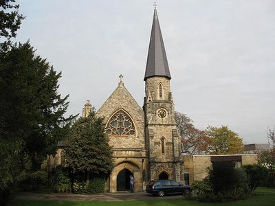
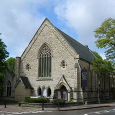
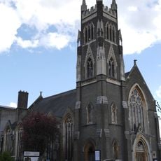
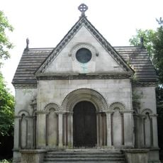
St Margaret's Church, Putney, Anglican church in Putney, England
St Margaret's Church sits on Putney Park Lane with a cruciform floor plan, featuring a bell tower and slated spire at its southwest corner. The building forms a solid presence on the street, marking the landscape of this area.
The building began as Grove Chapel in 1859 for Nonconformist worship and was transformed into St Margaret's Church in 1912 as Putney grew. This change reflects how the location adapted to serve the expanding community.
The church plays an active role in the community and offers weekly shelter for homeless people during winter months through a partnership with Glass Door. This work reflects how the building serves purposes beyond worship in the local area.
The building offers both in-person and live-streamed services through Facebook, with daily Evening Prayer sessions held at 6 p.m. Visitors should check ahead about opening times, as access may vary depending on the type of service or event taking place.
Unlike traditional Anglican churches that face east, this building is oriented toward the north due to its origins as a Baptist chapel. This unusual orientation preserves the building's architectural heritage and sets it apart from other churches in the area.
Location: London Borough of Wandsworth
Website: http://stmargaretsputney.org
GPS coordinates: 51.45910,-0.23440
Latest update: December 14, 2025 18:03
Bolan's Rock Shrine
815 m
Roehampton House
792 m
Montague Arms
1.1 km
All Saints' Church, Putney Common
977 m
Grove House, Roehampton
898 m
King's Head
1.1 km
Drinking Fountain
1.1 km
Polish Church of St. John the Evangelist, Putney
1 km
Putney Arts Theatre
978 m
Putney Park House
232 m
Fairacres, Roehampton
715 m
Putney Methodist Church
904 m
Putney Pocket Park
966 m
Roehampton War Memorial
979 m
Binley House
976 m
Elliott School
776 m
Mausoleum In Grounds Of Grove House
792 m
Table Tomb To Robert Wood
971 m
Table Tomb To Stratford Canning
978 m
Table Tomb Inscribed To Joseph Lucas
965 m
Charcot House
1.1 km
Winchfield House And Abutting Chimney
1 km
Grove House Dummy Bridge To The Lake
914 m
Milestone At Junction With Rocks Lane
960 m
Table Tomb At Entrance To The Ground
989 m
Milepost, Rocks Lane SW13, at S end of railway bridge embankment RAIL
957 m
Milestone, Upper Richmond Road; Roehampton
972 m
Milestone, Lower Richmond Road
1.1 kmVisited this place? Tap the stars to rate it and share your experience / photos with the community! Try now! You can cancel it anytime.
Discover hidden gems everywhere you go!
From secret cafés to breathtaking viewpoints, skip the crowded tourist spots and find places that match your style. Our app makes it easy with voice search, smart filtering, route optimization, and insider tips from travelers worldwide. Download now for the complete mobile experience.
A unique approach to discovering new places❞
— Le Figaro
All the places worth exploring❞
— France Info
A tailor-made excursion in just a few clicks❞
— 20 Minutes