Hodgemoor Wood

Log in to your account

AroundUs is a community-driven map of interesting places, built by curious explorers like you. It grows with every review, story, and photo you share.
Connect to save your favorite spots, contribute locations, and create personalized routes.
Continue with Google
Continue with Apple
Continue with X
Continue with Facebook
Continue with email
By continuing, you accept our Terms and Conditions and our Privacy Policy
Create an account
Add to collection
Map
Suggest a change
Share

Hodgemoor Wood, Protected forest in Buckinghamshire, England.

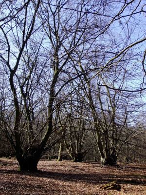
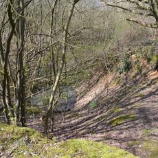
Hodgemoor Wood is a 102-hectare forest with broad-leaved trees growing on varied soil types including mottled clays, sands, and gravels. Multiple tracks and wide rides run through the woodland, making it easy to walk or cycle through the different parts.

Written records trace the woodland back to at least the 13th century, with ancient coppiced oak, beech, and hornbeam trees still present throughout. The forest structure reflects centuries of management practices combined with natural growth.

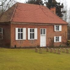
The woodland housed a refugee camp from 1946 to 1962 that sheltered hundreds of Polish soldiers and their families after World War II. This period shaped the area as a place of refuge and recovery during a difficult time in European history.

The main entry points are along Bottrells Lane, which provides access to the network of walking and cycling tracks. The broad paths make navigation straightforward and suitable for visitors of different abilities exploring the woodland.

The woodland supports around 700 species of fungi, ranking among the richest fungal habitats in the Buckinghamshire Chilterns. This exceptional diversity of fungi makes the area especially valuable for visitors interested in woodland ecology.

Location: Buckinghamshire

GPS coordinates: 51.63243,-0.60207

Latest update: December 14, 2025 13:04

Photos
Around this place
Bekonscot
United Kingdom

Bekonscot

3.6 km
Milton's Cottage
United Kingdom

Milton's Cottage

2 km
The Vache
United Kingdom

The Vache

2.9 km
Shrubs Wood
United Kingdom

Shrubs Wood

3.7 km
The Water Tower, Coleshill
United Kingdom

The Water Tower, Coleshill

2.5 km
Beaconsfield Town Hall
United Kingdom

Beaconsfield Town Hall

3.8 km
Froghall Brickworks
United Kingdom

Froghall Brickworks

1 km
Church of All Saints, Coleshill
United Kingdom

Church of All Saints, Coleshill

2.6 km
Parish Church of St Giles
United Kingdom

Parish Church of St Giles

2.2 km
Church of Holy Trinity
United Kingdom

Church of Holy Trinity

1.6 km
Saddlers House  The Feathers Public House
United Kingdom

Saddlers House The Feathers Public House

2.2 km
Gott's Monument At The National Society For Epilepsy
United Kingdom

Gott's Monument At The National Society For Epilepsy

3.7 km
41, Whielden Street
United Kingdom

41, Whielden Street

3.8 km
44 46, Whielden Street
United Kingdom

44 46, Whielden Street

3.8 km
Chalfont Grove
United Kingdom

Chalfont Grove

2.8 km
The Ivy House Public House
United Kingdom

The Ivy House Public House

2.6 km
Jordans Meeting House
United Kingdom

Jordans Meeting House

2.6 km
Outbuildings To Rear Of Number 38  The Saracen's Head Public House
United Kingdom

Outbuildings To Rear Of Number 38 The Saracen's Head Public House

3.8 km
40 42, Whielden Street
United Kingdom

40 42, Whielden Street

3.8 km
Milestone To North Of Mill Lane Opposite Misbourne House
United Kingdom

Milestone To North Of Mill Lane Opposite Misbourne House

2.2 km
43, Whielden Street
United Kingdom

43, Whielden Street

3.8 km
58, Broadway
United Kingdom

58, Broadway

3.8 km
Mayflower Barn, To South West Of Old Jordans Hostel
United Kingdom

Mayflower Barn, To South West Of Old Jordans Hostel

2.4 km
60, Broadway
United Kingdom

60, Broadway

3.8 km
Milestone, Chesham Lane: at northern jct of Monument Lane, to left of entrance to the Chesham Centre (Hospital)
United Kingdom

Milestone, Chesham Lane: at northern jct of Monument Lane, to left of entrance to the Chesham Centre (Hospital)

3.7 km
Milestone, Amersham Road; parish boundary with St Peter
United Kingdom

Milestone, Amersham Road; parish boundary with St Peter

2.9 km
Milestone, Amersham Road; opp. the Ivy House PH, close to Pollards Wood Golf Course, North Harewood Down House
United Kingdom

Milestone, Amersham Road; opp. the Ivy House PH, close to Pollards Wood Golf Course, North Harewood Down House

2.6 km
Milestone, London Road East; SE of Bury End Roundabout, beyond houses, 25m before Gas Compound
United Kingdom

Milestone, London Road East; SE of Bury End Roundabout, beyond houses, 25m before Gas Compound

3.3 km
Show the full map
Reviews

Visited this place? Tap the stars to rate it and share your experience / photos with the community! Try now! You can cancel it anytime.

« Hodgemoor Wood - Protected forest in Buckinghamshire, England » is provided by Around Us (aroundus.com). Images and texts are derived from Wikimedia project under a Creative Commons license. You are allowed to copy, distribute, and modify copies of this page, under the conditions set by the license, as long as this note is clearly visible.

Discover hidden gems everywhere you go!

From secret cafés to breathtaking viewpoints, skip the crowded tourist spots and find places that match your style. Our app makes it easy with voice search, smart filtering, route optimization, and insider tips from travelers worldwide. Download now for the complete mobile experience.

Around Us App Screenshot

A unique approach to discovering new places

Le Figaro

All the places worth exploring

France Info

A tailor-made excursion in just a few clicks

20 Minutes