Enable Location

We need your location to show you interesting places around you

Discover nearby places

Find interesting locations and hidden gems around you

Precise directions

Get accurate directions and distances to places

Your location is never shared with other users. It's only used when you tap the location button.

Shute House

Log in to your account

Start exploring — it's free

Trusted by 63,029 travelers worldwide

Continue with Google
Continue with Apple
or

We will send you a code to connect

By continuing, you accept our Terms and Conditions and our Privacy Policy

Check your inbox

We've sent a pincode in your inbox. Please enter the code below.

Shute House
Discussion Reviews 1 Photos
3.6k Popularity

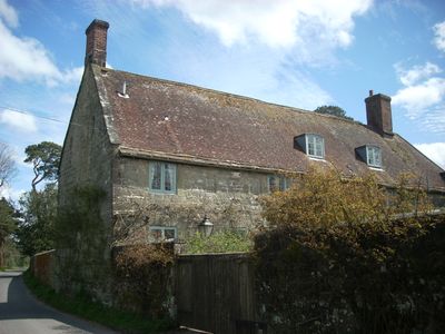
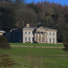
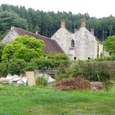
Shute House, Grade II listed building in Donhead St Mary, England

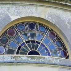
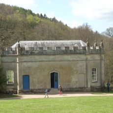
Shute House is a Grade II listed building with a 16th-century rectory core that was expanded in the early 1700s, located in Donhead St Mary in Wiltshire. The main house sits within a notable garden composition that combines formal and naturalistic design elements.

The property began as a Church of England rectory and was sold in the 1940s, receiving its name Shute House by 1955. This change marked the start of its life as a private residence with a carefully developed garden.

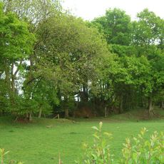
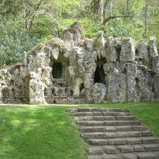
The gardens were designed by landscape architect Geoffrey Jellicoe in the late 1960s and early 1980s as a significant garden composition. Water channels and ponds shape the grounds and reflect a thoughtful design that brings together nature and human craft.

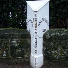
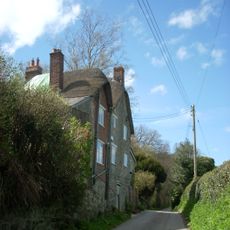
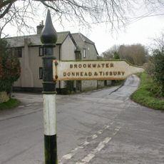
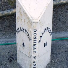
The property is located in southern Wiltshire near the Dorset border, about 2.5 miles east of Shaftesbury. The house sits in a rural setting with access via local roads through the countryside.

The estate is fed by natural springs whose water flows through carefully crafted channels to grottoes and ponds. These water systems form one of the most striking features of the garden design and show an unusual integration of landscape and planning.

The community of curious travelers

AroundUs brings together thousands of curated places, local tips, and hidden gems, enriched daily by 60,000 contributors worldwide.

Start exploring
Location
GPS coordinates
51.01998,-2.13767
Latest update
December 12, 2025 07:52
Around this place
Old Wardour Castle
United Kingdom

Old Wardour Castle

3.9 km
Ferne House
United Kingdom

Ferne House

3.4 km
New Wardour Castle
United Kingdom

New Wardour Castle

3.4 km
Pythouse
United Kingdom

Pythouse

4 km
Castle Rings
United Kingdom

Castle Rings

1.8 km
Church of St Andrew
United Kingdom

Church of St Andrew

1.1 km
Church of St Leonard
United Kingdom

Church of St Leonard

2.7 km
Church of St John the Baptist
United Kingdom

Church of St John the Baptist

1.9 km
Church of St Mary
United Kingdom

Church of St Mary

247 m
Donhead House
United Kingdom

Donhead House

1 km
Pender Monument In The Churchyard, About 10 Metres South Of The Church Of St Andrew
United Kingdom

Pender Monument In The Churchyard, About 10 Metres South Of The Church Of St Andrew

1.1 km
Wardour Castle Chapel
United Kingdom

Wardour Castle Chapel

3.4 km
Grotto To North East Of Old Wardour Castle
United Kingdom

Grotto To North East Of Old Wardour Castle

4 km
Mile Post Outside No 56
United Kingdom

Mile Post Outside No 56

4.2 km
Carpenters
United Kingdom

Carpenters

219 m
Guide Post At Cross Roads
United Kingdom

Guide Post At Cross Roads

2.3 km
Archway On Trackway To South West Of Old Wardour
United Kingdom

Archway On Trackway To South West Of Old Wardour

3.3 km
The Croft
United Kingdom

The Croft

276 m
Old Wardour House
United Kingdom

Old Wardour House

3.8 km
Whitesheet Hill milestone
United Kingdom

Whitesheet Hill milestone

3.7 km
Guide Post Opposite North West Entrance To Churchyard Of Church Of St Leonard
United Kingdom

Guide Post Opposite North West Entrance To Churchyard Of Church Of St Leonard

2.7 km
Milestone Near Parish Boundary With Donhead St Andrew
United Kingdom

Milestone Near Parish Boundary With Donhead St Andrew

3.3 km
Banqueting House At Old Wardour Park
United Kingdom

Banqueting House At Old Wardour Park

3.8 km
Milepost, Ludwell; E of village next to jcn Dennis Lane
United Kingdom

Milepost, Ludwell; E of village next to jcn Dennis Lane

1.8 km
Milepost In Front Of Number 150
United Kingdom

Milepost In Front Of Number 150

2.4 km
Milepost Opposite Coombe Corner
United Kingdom

Milepost Opposite Coombe Corner

2.2 km
Milepost, Landsley Farm; 100m W entrance St Mary's School opp. Mile End Cottage
United Kingdom

Milepost, Landsley Farm; 100m W entrance St Mary's School opp. Mile End Cottage

3.2 km
Milestone, Semley Road, Shaftesbury; 30m N lay-by outside reservoir
United Kingdom

Milestone, Semley Road, Shaftesbury; 30m N lay-by outside reservoir

3.6 km
Show the full map
Reviews
Share your experience

No review yet

Discussions
Start a discussion...

No discussion yet

« Shute House - Grade II listed building in Donhead St Mary, England » is provided by Around Us (aroundus.com). Images and texts are derived from Wikimedia project under a Creative Commons license. You are allowed to copy, distribute, and modify copies of this page, under the conditions set by the license, as long as this note is clearly visible.

Discover hidden gems everywhere you go!

From secret cafés to breathtaking viewpoints, skip the crowded tourist spots and find places that match your style. Our app makes it easy with voice search, smart filtering, route optimization, and insider tips from travelers worldwide. Download now for the complete mobile experience.

Around Us App Screenshot

A unique approach to discovering new places

Le Figaro

All the places worth exploring

France Info

A tailor-made excursion in just a few clicks

20 Minutes

Around Us
Travel Guide & Maps
Download

Send to your phone

QR Code
1

Open the camera app on your mobile.

2

Point at the QR code with your camera. A notification will appear.

3

Tap the notification to open the link.