Eagle Falls

Log in to your account

AroundUs is a community-driven map of interesting places, built by curious explorers like you. It grows with every review, story, and photo you share.
Connect to save your favorite spots, contribute locations, and create personalized routes.
Continue with Google
Continue with Apple
Continue with X
Continue with Facebook
Continue with email
By continuing, you accept our Terms and Conditions and our Privacy Policy
Create an account
Add to collection
Map
Suggest a change
Share

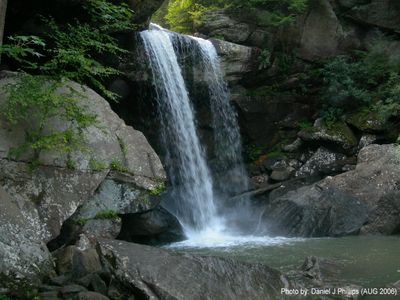
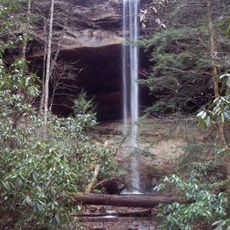
Eagle Falls, Waterfall in Cumberland Falls State Resort Park, Kentucky

Eagle Falls drops over a rocky cliff where Eagle Creek meets the Cumberland River, creating a single plunge cascade in the middle of the park. The water tumbles down and produces a mist that spreads across the base of the falls.

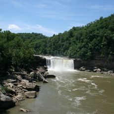
This location became protected as part of Cumberland Falls State Resort Park in the early 1900s, making it accessible to the public. The falls and surrounding landscape have maintained their essential character throughout the decades.

Trail 9 leading to Eagle Falls represents a connection between Kentucky residents and nature through maintained hiking paths and outdoor recreation.

The route follows a marked trail with some elevation changes and rocky ground that requires sturdy footwear for safe travel. Visitors should expect varying conditions depending on the season and recent weather.

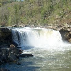
During high water periods, portions of the access path may become submerged, requiring visitors to follow painted markers on rocks to navigate safely. These temporary detours change the experience and demonstrate how dynamic this location interacts with water levels.

Location: Kentucky

Part of: Eagle Creek

GPS coordinates: 36.84361,-84.34351

Latest update: December 12, 2025 07:59

Photos
Around this place
Cumberland Falls
United States of America

Cumberland Falls

562 m
Cumberland Falls State Resort Park
United States of America

Cumberland Falls State Resort Park

1 km
Tombstone Junction
United States of America

Tombstone Junction

1.6 km
Yahoo Falls
United States of America

Yahoo Falls

17.1 km
United States of America

Dog Slaughter Falls

3.3 km
Big South Fork Scenic Railway
United States of America

Big South Fork Scenic Railway

20 km
United States of America

Sue Bennett College

38.7 km
Sander's Cafe and Museum
United States of America

Sander's Cafe and Museum

25.7 km
Dr. Thomas Walker State Historic Site
United States of America

Dr. Thomas Walker State Historic Site

37.8 km
McCreary County Museum
United States of America

McCreary County Museum

20 km
Mill Springs Mill
United States of America

Mill Springs Mill

40.1 km
Battle of Dutton's Hill Monument
United States of America

Battle of Dutton's Hill Monument

38.3 km
Cumberland Inn Museum
United States of America

Cumberland Inn Museum

20.4 km
Federal Building-Courthouse
United States of America

Federal Building-Courthouse

39.2 km
First Christian Church
United States of America

First Christian Church

24.7 km
East Main Street Bridge
United States of America

East Main Street Bridge

25.3 km
Burnside Methodist Church
United States of America

Burnside Methodist Church

27.9 km
First Evangelical Reformed Church
United States of America

First Evangelical Reformed Church

37.3 km
Burnside Masonic Lodge
United States of America

Burnside Masonic Lodge

27.9 km
Old Classroom Building, Union College
United States of America

Old Classroom Building, Union College

40.6 km
Carnegie Library
United States of America

Carnegie Library

25.2 km
Lane Theater
United States of America

Lane Theater

19.8 km
Somerset Downtown Commercial District
United States of America

Somerset Downtown Commercial District

36.1 km
Stearns Administrative and Commercial District
United States of America

Stearns Administrative and Commercial District

20 km
Withers House
United States of America

Withers House

36.2 km
Levi Jackson Wilderness Road State Park
United States of America

Levi Jackson Wilderness Road State Park

37.8 km
Indian Mountain State Park
United States of America

Indian Mountain State Park

34 km
Laurel River Lake
United States of America

Laurel River Lake

17.3 km
Show the full map
Reviews

Visited this place? Tap the stars to rate it and share your experience / photos with the community! Try now! You can cancel it anytime.

« Eagle Falls - Waterfall in Cumberland Falls State Resort Park, Kentucky » is provided by Around Us (aroundus.com). Images and texts are derived from Wikimedia project under a Creative Commons license. You are allowed to copy, distribute, and modify copies of this page, under the conditions set by the license, as long as this note is clearly visible.

Discover hidden gems everywhere you go!

From secret cafés to breathtaking viewpoints, skip the crowded tourist spots and find places that match your style. Our app makes it easy with voice search, smart filtering, route optimization, and insider tips from travelers worldwide. Download now for the complete mobile experience.

Around Us App Screenshot

A unique approach to discovering new places

Le Figaro

All the places worth exploring

France Info

A tailor-made excursion in just a few clicks

20 Minutes