Enable Location

We need your location to show you interesting places around you

Discover nearby places

Find interesting locations and hidden gems around you

Precise directions

Get accurate directions and distances to places

Your location is never shared with other users. It's only used when you tap the location button.

Dr. Thomas Walker State Historic Site

Log in to your account

Start exploring — it's free

Trusted by 63,003 travelers worldwide

Continue with Google
Continue with Apple
or

We will send you a code to connect

By continuing, you accept our Terms and Conditions and our Privacy Policy

Check your inbox

We've sent a pincode in your inbox. Please enter the code below.

Dr. Thomas Walker State Historic Site
Discussion Reviews 1 Photos
2.5k Popularity

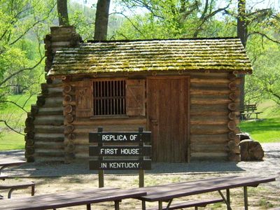
Dr. Thomas Walker State Historic Site, State historic site in Barbourville, Kentucky, United States.

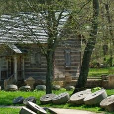
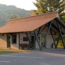
Dr. Thomas Walker State Historic Site is a protected area in Kentucky featuring a replica cabin, walking trails, and an interpretive center focused on early frontier exploration. The grounds contain several acres with various spaces to explore and learn about pioneer times.

A physician and explorer named Thomas Walker built one of Kentucky's first structures here in 1750 and contributed to European expansion westward. This event marked an important moment in the early settlement of the region.

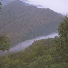
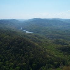
The site honors early pioneers who ventured into this region through exhibits and educational programs that show how people lived and worked during frontier times. Visitors learn how this settlement connected to the first European explorations moving westward.

The grounds are open year-round for walking and exploring, with picnic tables available at different spots. Visitors should allow time to view displays at the center and take in the outdoor areas.

The site documents the explorer's journal records from his expedition and the founding of this location. Visitors can see the exact spot he described and trace his journey directly.

The community of curious travelers

AroundUs brings together thousands of curated places, local tips, and hidden gems, enriched daily by 60,000 contributors worldwide.

Start exploring
Location
GPS coordinates
36.83940,-83.91930
Latest update
December 13, 2025 11:48
Around this place
Cumberland Gap
United States of America

Cumberland Gap

34.2 km
Cumberland Gap National Historical Park
United States of America

Cumberland Gap National Historical Park

33.4 km
Cumberland Falls State Resort Park
United States of America

Cumberland Falls State Resort Park

36.8 km
Pine Mountain State Resort Park
United States of America

Pine Mountain State Resort Park

21.2 km
United States of America

Dog Slaughter Falls

35 km
United States of America

Tri-State Peak

34.3 km
United States of America

Sue Bennett College

35.2 km
Sander's Cafe and Museum
United States of America

Sander's Cafe and Museum

20.5 km
Cumberland Inn Museum
United States of America

Cumberland Inn Museum

25.3 km
Federal Building-Courthouse
United States of America

Federal Building-Courthouse

35.2 km
First Christian Church
United States of America

First Christian Church

19.8 km
Kentucky Route 2014 Bridge
United States of America

Kentucky Route 2014 Bridge

16.6 km
East Main Street Bridge
United States of America

East Main Street Bridge

20.1 km
Old Classroom Building, Union College
United States of America

Old Classroom Building, Union College

3.2 km
Speed Hall
United States of America

Speed Hall

4.4 km
Pineville Courthouse Square Historic District
United States of America

Pineville Courthouse Square Historic District

21.8 km
Grant-Lee Hall
United States of America

Grant-Lee Hall

36.8 km
Carnegie Library
United States of America

Carnegie Library

19.8 km
Lane Theater
United States of America

Lane Theater

24.2 km
Mitchell Building-First State Bank Building
United States of America

Mitchell Building-First State Bank Building

4.2 km
American Association, Limited, Office Building
United States of America

American Association, Limited, Office Building

31.5 km
Middlesboro Downtown Commercial District
United States of America

Middlesboro Downtown Commercial District

31.6 km
Barbourville Commercial District
United States of America

Barbourville Commercial District

4 km
Soldiers and Sailors Memorial Gymnasium
United States of America

Soldiers and Sailors Memorial Gymnasium

4.5 km
Levi Jackson Wilderness Road State Park
United States of America

Levi Jackson Wilderness Road State Park

29.2 km
Indian Mountain State Park
United States of America

Indian Mountain State Park

34.6 km
Laurel River Lake
United States of America

Laurel River Lake

30.1 km
Cumberland Gap Historic District
United States of America

Cumberland Gap Historic District

34.1 km
Show the full map
Reviews
Share your experience

No review yet

Discussions
Start a discussion...

No discussion yet

« Dr. Thomas Walker State Historic Site - State historic site in Barbourville, Kentucky, United States » is provided by Around Us (aroundus.com). Images and texts are derived from Wikimedia project under a Creative Commons license. You are allowed to copy, distribute, and modify copies of this page, under the conditions set by the license, as long as this note is clearly visible.

Discover hidden gems everywhere you go!

From secret cafés to breathtaking viewpoints, skip the crowded tourist spots and find places that match your style. Our app makes it easy with voice search, smart filtering, route optimization, and insider tips from travelers worldwide. Download now for the complete mobile experience.

Around Us App Screenshot

A unique approach to discovering new places

Le Figaro

All the places worth exploring

France Info

A tailor-made excursion in just a few clicks

20 Minutes

Around Us
Travel Guide & Maps
Download

Send to your phone

QR Code
1

Open the camera app on your mobile.

2

Point at the QR code with your camera. A notification will appear.

3

Tap the notification to open the link.