Cumberland Gap National Historical Park

Log in to your account

AroundUs is a community-driven map of interesting places, built by curious explorers like you. It grows with every review, story, and photo you share.
Connect to save your favorite spots, contribute locations, and create personalized routes.
Continue with Google
Continue with Apple
Continue with X
Continue with Facebook
Continue with email
By continuing, you accept our Terms and Conditions and our Privacy Policy
Create an account
Add to collection
Map
Suggest a change
Share

Cumberland Gap National Historical Park, National Historical Park in Cumberland Gap, Kentucky

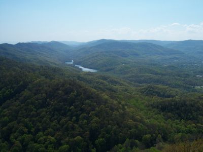
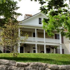
Cumberland Gap National Historical Park is a protected area covering roughly 24,000 acres across Kentucky, Virginia, and Tennessee that combines Appalachian mountain ridges with forests and limestone outcrops. The landscape includes trails that wind through valleys and over crests, offering views of the surrounding highlands.

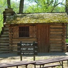
The gap became the main crossing route for settlers heading west in the 18th century, and more than 300,000 people passed through it during frontier expansion. The park was established in 1940 to preserve the passage and its role in American history.

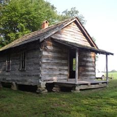
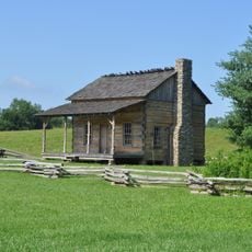
Hensley Settlement on the mountainside preserves log homes and open fields that show how families lived here in the early 20th century. Visitors see old barns, tools, and gardens that make the daily life of mountain residents understandable.

Wilderness Road Campground offers spaces with electrical hookups and restroom facilities near the trails. Visitors should bring sturdy footwear, as many paths cross steep terrain and can become slippery after rain.

Gap Cave stretches for roughly 20 miles (32 kilometers) underground and contains four levels with passages, springs, and animals that live only in caves. Some sections are narrow enough that explorers must crawl through, while other chambers are large enough for small groups.

Location: Kentucky

Location: Virginia

Location: Tennessee

Inception: June 11, 1940

Operator: National Park Service

Website: https://nps.gov/cuga

GPS coordinates: 36.60420,-83.68720

Latest update: December 20, 2025 13:29

Photos
Around this place
Norris Lake
United States of America

Norris Lake

37.8 km
Pine Mountain State Resort Park
United States of America

Pine Mountain State Resort Park

16.5 km
Hensley Settlement
United States of America

Hensley Settlement

15.9 km
United States of America

Wilderness Road State Park

15 km
United States of America

Tri-State Peak

1.1 km
Dr. Thomas Walker State Historic Site
United States of America

Dr. Thomas Walker State Historic Site

33.4 km
Claiborne County Jail
United States of America

Claiborne County Jail

19.9 km
Henderson Chapel African Methodist Episcopal Zion Church
United States of America

Henderson Chapel African Methodist Episcopal Zion Church

39.1 km
Kincaid-Ausmus House
United States of America

Kincaid-Ausmus House

16 km
Kincaid House
United States of America

Kincaid House

19.4 km
James Weir House
United States of America

James Weir House

19.8 km
Kentucky Route 2014 Bridge
United States of America

Kentucky Route 2014 Bridge

21.5 km
Smith-Little-Mars House
United States of America

Smith-Little-Mars House

28 km
Graham-Kivett House
United States of America

Graham-Kivett House

19.8 km
Old Classroom Building, Union College
United States of America

Old Classroom Building, Union College

33.1 km
Speed Hall
United States of America

Speed Hall

34.7 km
William Sayers Homestead
United States of America

William Sayers Homestead

10.5 km
Pineville Courthouse Square Historic District
United States of America

Pineville Courthouse Square Historic District

17.5 km
Grant-Lee Hall
United States of America

Grant-Lee Hall

3.4 km
McClain-Ellison House
United States of America

McClain-Ellison House

27.2 km
Mitchell Building-First State Bank Building
United States of America

Mitchell Building-First State Bank Building

34.2 km
American Association, Limited, Office Building
United States of America

American Association, Limited, Office Building

2.8 km
Middlesboro Downtown Commercial District
United States of America

Middlesboro Downtown Commercial District

2.4 km
Barbourville Commercial District
United States of America

Barbourville Commercial District

34.2 km
Wilderness Road State Park
United States of America

Wilderness Road State Park

14.7 km
Soldiers and Sailors Memorial Gymnasium
United States of America

Soldiers and Sailors Memorial Gymnasium

34.6 km
Kesterson-Watkins House
United States of America

Kesterson-Watkins House

21.2 km
Abraham Lincoln Library and Museum
United States of America

Abraham Lincoln Library and Museum

3.7 km
Show the full map
Reviews

Visited this place? Tap the stars to rate it and share your experience / photos with the community! Try now! You can cancel it anytime.

« Cumberland Gap National Historical Park - National Historical Park in Cumberland Gap, Kentucky » is provided by Around Us (aroundus.com). Images and texts are derived from Wikimedia project under a Creative Commons license. You are allowed to copy, distribute, and modify copies of this page, under the conditions set by the license, as long as this note is clearly visible.

Discover hidden gems everywhere you go!

From secret cafés to breathtaking viewpoints, skip the crowded tourist spots and find places that match your style. Our app makes it easy with voice search, smart filtering, route optimization, and insider tips from travelers worldwide. Download now for the complete mobile experience.

Around Us App Screenshot

A unique approach to discovering new places

Le Figaro

All the places worth exploring

France Info

A tailor-made excursion in just a few clicks

20 Minutes