·

Enable Location

We need your location to show you interesting places around you

Discover nearby places

Find interesting locations and hidden gems around you

Precise directions

Get accurate directions and distances to places

Your location is never shared with other users. It's only used when you tap the location button.

Claiborne County Jail

Log in to your account

Start exploring — it's free

Trusted by 62,752 travelers worldwide

Continue with Google
Continue with Apple
or

We will send you a code to connect

By continuing, you accept our Terms and Conditions and our Privacy Policy

Check your inbox

We've sent a pincode in your inbox. Please enter the code below.

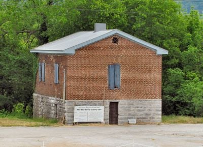
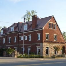
Claiborne County Jail, historic jail

The Claiborne County Jail is a two-story limestone and brick structure built in 1819 in Tazewell, Tennessee, with a simple rectangular form typical of early 19th-century design. Its interior features a central holding area surrounded by steel bars, with hallways on each side and quarters for the jailer.

The county's original jail, a basic structure built in 1804, was replaced in 1819 by the current stone building, which operated as the county jail until 1931. After a new facility was constructed elsewhere, this historic structure was eventually recognized on the National Register of Historic Places in 2007.

The jail was a focal point in town life, where public executions drew crowds to witness justice being carried out. Its presence shaped how the community understood law and order during Tazewell's early years.

The building sits along Highway 33 near First Century Bank and is easy to locate. It is managed by the local historical society, which organizes tours and provides additional information about the site.

A curious anecdote from the sheriff's family recalls when deputy Newt Mink locked the young twin sons of Sheriff Lafayette Payne in a cell to keep them from causing mischief around town. This tale shows how the building was woven into everyday community life.

The community of curious travelers

AroundUs brings together thousands of curated places, local tips, and hidden gems, enriched daily by 60,000 contributors worldwide.

Start exploring
Location
GPS coordinates
36.45250,-83.56890
Latest update
February 9, 2026 07:45
Around this place
Cumberland Gap
United States of America

Cumberland Gap

19.3 km
Norris Lake
United States of America

Norris Lake

32.6 km
Cumberland Gap National Historical Park
United States of America

Cumberland Gap National Historical Park

19.9 km
Cherokee Lake
United States of America

Cherokee Lake

29 km
Hensley Settlement
United States of America

Hensley Settlement

24.4 km
United States of America

Wilderness Road State Park

20.6 km
Panther Creek State Park
United States of America

Panther Creek State Park

30.4 km
United States of America

Tri-State Peak

19.1 km
Tate Springs Springhouse
United States of America

Tate Springs Springhouse

23.7 km
Henderson Chapel African Methodist Episcopal Zion Church
United States of America

Henderson Chapel African Methodist Episcopal Zion Church

19.6 km
Kincaid-Ausmus House
United States of America

Kincaid-Ausmus House

21.6 km
Kincaid House
United States of America

Kincaid House

22.8 km
James Weir House
United States of America

James Weir House

176 m
Smith-Little-Mars House
United States of America

Smith-Little-Mars House

32.3 km
Richland
United States of America

Richland

32.8 km
Graham-Kivett House
United States of America

Graham-Kivett House

225 m
William Cocke House
United States of America

William Cocke House

19.6 km
Lea Springs
United States of America

Lea Springs

31 km
William Sayers Homestead
United States of America

William Sayers Homestead

17.8 km
Grant-Lee Hall
United States of America

Grant-Lee Hall

16.5 km
McClain-Ellison House
United States of America

McClain-Ellison House

32.1 km
American Association, Limited, Office Building
United States of America

American Association, Limited, Office Building

21.7 km
Middlesboro Downtown Commercial District
United States of America

Middlesboro Downtown Commercial District

21.7 km
Poplar Hill
United States of America

Poplar Hill

32.3 km
Wilderness Road State Park
United States of America

Wilderness Road State Park

20.2 km
Kesterson-Watkins House
United States of America

Kesterson-Watkins House

8.1 km
Abraham Lincoln Library and Museum
United States of America

Abraham Lincoln Library and Museum

16.3 km
Cumberland Gap Historic District
United States of America

Cumberland Gap Historic District

19.3 km
Show the full map
« Claiborne County Jail - historic jail » is provided by Around Us (aroundus.com). Images and texts are derived from Wikimedia project under a Creative Commons license. You are allowed to copy, distribute, and modify copies of this page, under the conditions set by the license, as long as this note is clearly visible.

Discover hidden gems everywhere you go!

From secret cafés to breathtaking viewpoints, skip the crowded tourist spots and find places that match your style. Our app makes it easy with voice search, smart filtering, route optimization, and insider tips from travelers worldwide. Download now for the complete mobile experience.

Around Us App Screenshot

A unique approach to discovering new places

Le Figaro

All the places worth exploring

France Info

A tailor-made excursion in just a few clicks

20 Minutes

Around Us
Travel Guide & Maps
Download

Send to your phone

QR Code
1

Open the camera app on your mobile.

2

Point at the QR code with your camera. A notification will appear.

3

Tap the notification to open the link.