Enable Location

We need your location to show you interesting places around you

Discover nearby places

Find interesting locations and hidden gems around you

Precise directions

Get accurate directions and distances to places

Your location is never shared with other users. It's only used when you tap the location button.

Greene County

Log in to your account

Start exploring — it's free

Trusted by 62,036 travelers worldwide

Continue with Google
Continue with Apple
or

We will send you a code to connect

By continuing, you accept our Terms and Conditions and our Privacy Policy

Check your inbox

We've sent a pincode in your inbox. Please enter the code below.

Greene County, Administrative county in eastern North Carolina, US.

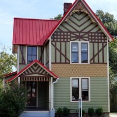
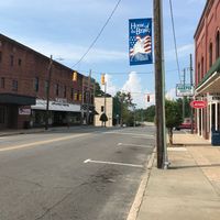
Greene County is an administrative county in eastern North Carolina, characterized by rural farmland and small-town features. Snow Hill functions as the county seat where government services and local commerce serve the region's residents.

The county was established in 1791 from northern Dobbs County and renamed in 1799 to honor Revolutionary War General Nathanael Greene. This naming reflected the region's recognition of his military contributions during the nation's founding.

The region reflects its Native American heritage through place names and local traditions that remain part of the community's identity. Visitors can encounter this past at historical sites that mark significant moments in the area's indigenous history.

Government services and administrative offices are centered in Snow Hill and accessible to residents and visitors. The rural spread of the region means having a vehicle is helpful for moving between different areas.

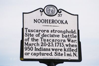
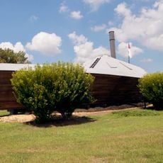
The area was home to Fort Neoheroka, the site of a decisive 1713 battle that shaped the region's trajectory. This historical conflict remains a defining moment in the local story.

The community of curious travelers

AroundUs brings together thousands of curated places, local tips, and hidden gems, enriched daily by 60,000 contributors worldwide.

Start exploring
Location
Inception
1791
Capital city
Snow Hill
Shares border with
Pitt County, Lenoir County, Wayne County, Wilson County
GPS coordinates
35.49000,-77.68000
Latest update
December 7, 2025 20:22
Around this place
Fort Neoheroka
United States of America

Fort Neoheroka

4.7 km
Stallings Air Base
United States of America

Stallings Air Base

18.8 km
Harmony Hall
United States of America

Harmony Hall

27.2 km
William H. Long House
United States of America

William H. Long House

28.1 km
Temple Israel
United States of America

Temple Israel

25.6 km
La Grange Presbyterian Church
United States of America

La Grange Presbyterian Church

22.9 km
E. B. Ficklen House
United States of America

E. B. Ficklen House

30.4 km
American Tobacco Company Prizery
United States of America

American Tobacco Company Prizery

26.1 km
Kinston Baptist-White Rock Presbyterian Church
United States of America

Kinston Baptist-White Rock Presbyterian Church

26.9 km
Jesse R. Moye House
United States of America

Jesse R. Moye House

30.6 km
Neuseway Nature Center and Planetarium
United States of America

Neuseway Nature Center and Planetarium

27 km
La Grange Historic District (North Carolina)
United States of America

La Grange Historic District (North Carolina)

22.9 km
Dickinson Avenue Historic District
United States of America

Dickinson Avenue Historic District

30.2 km
Lenoir County Courthouse
United States of America

Lenoir County Courthouse

27.5 km
B. W. Canady House
United States of America

B. W. Canady House

26.4 km
Mitchelltown Historic District
United States of America

Mitchelltown Historic District

26.3 km
Baptist Parsonage
United States of America

Baptist Parsonage

27.4 km
Hill–Grainger Historic District
United States of America

Hill–Grainger Historic District

26 km
Sumrell and McCoy Building
United States of America

Sumrell and McCoy Building

26.7 km
Cox-Ange House
United States of America

Cox-Ange House

25.6 km
Kennedy Memorial Home Historic District
United States of America

Kennedy Memorial Home Historic District

26.2 km
Greene County Courthouse
United States of America

Greene County Courthouse

3.9 km
Cedar Dell
United States of America

Cedar Dell

26.2 km
Jones-Lee House
United States of America

Jones-Lee House

30.6 km
Queen-Gordon Streets Historic District
United States of America

Queen-Gordon Streets Historic District

26.9 km
WITN-Tower
United States of America

WITN-Tower

29.5 km
CSS Neuse Museum
United States of America

CSS Neuse Museum

27.1 km
CSS Neuse II
United States of America

CSS Neuse II

26.9 km
Show the full map
Administrative divisions
« Greene County - Administrative county in eastern North Carolina, US » is provided by Around Us (aroundus.com). Images and texts are derived from Wikimedia project under a Creative Commons license. You are allowed to copy, distribute, and modify copies of this page, under the conditions set by the license, as long as this note is clearly visible.

Discover hidden gems everywhere you go!

From secret cafés to breathtaking viewpoints, skip the crowded tourist spots and find places that match your style. Our app makes it easy with voice search, smart filtering, route optimization, and insider tips from travelers worldwide. Download now for the complete mobile experience.

Around Us App Screenshot

A unique approach to discovering new places

Le Figaro

All the places worth exploring

France Info

A tailor-made excursion in just a few clicks

20 Minutes

Around Us
Travel Guide & Maps
Download

Send to your phone

QR Code
1

Open the camera app on your mobile.

2

Point at the QR code with your camera. A notification will appear.

3

Tap the notification to open the link.