Enable Location

We need your location to show you interesting places around you

Discover nearby places

Find interesting locations and hidden gems around you

Precise directions

Get accurate directions and distances to places

Your location is never shared with other users. It's only used when you tap the location button.

Walnut Lane Bridge

Log in to your account

Join the adventure

Create your free account and start exploring (like 60k+ others)

We will send you a code to connect

or
Continue with Google
Continue with Apple
By continuing, you accept our Terms and Conditions and our Privacy Policy

Check your inbox

We've sent a pincode in your inbox. Please enter the code below.

Walnut Lane Bridge

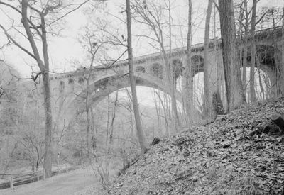
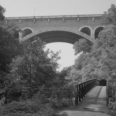
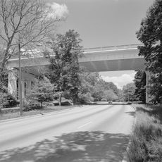
Walnut Lane Bridge, Concrete arch bridge in Wissahickon Valley Park, Philadelphia, United States.

Description

Walnut Lane Bridge is a concrete arch structure spanning Wissahickon Valley to link Germantown and Roxborough. The bridge consists of multiple concrete arches that rise gracefully above the creek, creating a continuous roadway for both vehicle and foot traffic.

History

The structure opened in 1908 and set world records for height and span in concrete arch design at that time. Its construction represented a major engineering achievement during an era when such technical accomplishments were rare and noteworthy.

Culture

The bridge represents an early effort to physically link separate neighborhoods and foster movement between communities across the valley. Walking or driving across it today, you experience a direct connection that once required long detours to reach the other side.

Practical

The bridge is open to both vehicles and pedestrians, offering clear views of the valley below. Visit during daylight hours when the structure is fully visible and traffic patterns are most predictable.

Did you know?

Construction required more than 40,000 tons of rubble concrete with minimal steel reinforcement due to material constraints in the early 1900s. This resourceful building method reveals how engineers adapted designs to match what was actually available at the time.

Location
Inception
1908
Official opening
October 14, 1908
Made from material
concrete
GPS coordinates
40.03222,-75.19972
Latest update
December 11, 2025 18:04

AroundUs brings together thousands of curated places, local tips, and hidden gems, enriched daily by 60,000 contributors worldwide. Discover all places nearby (Philadelphia).

Around this place
Wissahickon Valley Park
United States of America

Wissahickon Valley Park

1.1 km
Johnson House Historic Site
United States of America

Johnson House Historic Site

2 km
Historic RittenhouseTown
United States of America

Historic RittenhouseTown

837 m
Wissahickon Memorial Bridge
United States of America

Wissahickon Memorial Bridge

948 m
Alden Park Manor
United States of America

Alden Park Manor

1.3 km
Ravenhill
United States of America

Ravenhill

1.9 km
Ebenezer Maxwell House
United States of America

Ebenezer Maxwell House

1.5 km
Mennonite Meetinghouse
United States of America

Mennonite Meetinghouse

2 km
Oaks Cloister
United States of America

Oaks Cloister

2 km
Paper Mill Run
United States of America

Paper Mill Run

973 m
Tulpehocken Station Historic District
United States of America

Tulpehocken Station Historic District

1.6 km
Walnut Lane Memorial Bridge
United States of America

Walnut Lane Memorial Bridge

1 km
United States of America

Paul J. Gutman Library

1.3 km
The Monastery
United States of America

The Monastery

545 m
St. Peter's Episcopal Church of Germantown
United States of America

St. Peter's Episcopal Church of Germantown

1.4 km
St. Josaphat Roman Catholic Church in Philadelphia
United States of America

St. Josaphat Roman Catholic Church in Philadelphia

2 km
Mayfair House
United States of America

Mayfair House

884 m
Edward B. Seymour House
United States of America

Edward B. Seymour House

1.4 km
Malvern Hall
United States of America

Malvern Hall

1.7 km
Delmar Apartments
United States of America

Delmar Apartments

1.6 km
Church of the Annunciation, Philadelphia
United States of America

Church of the Annunciation, Philadelphia

2 km
Vernon-Wister House
United States of America

Vernon-Wister House

2 km
William C. Sharpless House
United States of America

William C. Sharpless House

2 km
Presser Home for Retired Music Teachers
United States of America

Presser Home for Retired Music Teachers

1.9 km
McCallum Manor
United States of America

McCallum Manor

1.6 km
Nugent Home for Baptists
United States of America

Nugent Home for Baptists

1.6 km
Smyser and English Pharmacy
United States of America

Smyser and English Pharmacy

1.6 km
Wyck Museum
United States of America

Wyck Museum

2 km
Show the full map
« Walnut Lane Bridge - Concrete arch bridge in Wissahickon Valley Park, Philadelphia, United States » is provided by Around Us (aroundus.com). Images and texts are derived from Wikimedia project under a Creative Commons license. You are allowed to copy, distribute, and modify copies of this page, under the conditions set by the license, as long as this note is clearly visible.

Discover hidden gems everywhere you go!

From secret cafés to breathtaking viewpoints, skip the crowded tourist spots and find places that match your style. Our app makes it easy with voice search, smart filtering, route optimization, and insider tips from travelers worldwide. Download now for the complete mobile experience.

Around Us App Screenshot

A unique approach to discovering new places

Le Figaro

All the places worth exploring

France Info

A tailor-made excursion in just a few clicks

20 Minutes

Around Us
Travel Guide & Maps
Download

Send to your phone

QR Code
1

Open the camera app on your mobile.

2

Point at the QR code with your camera. A notification will appear.

3

Tap the notification to open the link.