Enable Location

We need your location to show you interesting places around you

Discover nearby places

Find interesting locations and hidden gems around you

Precise directions

Get accurate directions and distances to places

Your location is never shared with other users. It's only used when you tap the location button.

Ben Williamson Memorial Bridge

Log in to your account

Start exploring — it's free

Trusted by 61,899 travelers worldwide

Continue with Google
Continue with Apple
or

We will send you a code to connect

By continuing, you accept our Terms and Conditions and our Privacy Policy

Check your inbox

We've sent a pincode in your inbox. Please enter the code below.

Ben Williamson Memorial Bridge

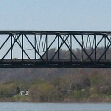
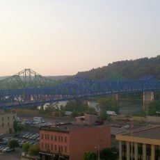
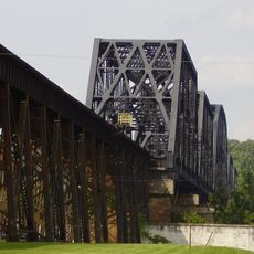
Ben Williamson Memorial Bridge, Road bridge in Ashland, Kentucky

The Ben Williamson Memorial Bridge is a road bridge that crosses the Ohio River between Kentucky and Ohio, featuring a cantilever structure with multiple traffic lanes. The span extends approximately 738 feet (225 meters) across the water, linking Ashland with Coal Grove in the neighboring state.

The bridge opened in 1931 as a toll crossing that linked the two banks of the Ohio River for the first time on this route. In 1941, it became toll-free, marking an important change for the community.

The bridge bears the name of Ben M. Williamson, a United States Senator and local businessman who shaped the region's development. It serves as a familiar landmark in Ashland's urban landscape, connecting two states on a route that locals and visitors cross daily.

The bridge is part of US Route 23 Spur and carries southbound traffic from Coal Grove to Ashland across three lanes. Visitors should know that this is primarily a vehicle route where traffic flows regularly throughout the day.

In 2007, the bridge was painted light green, a color connected to Ashland's city logo. This paint job creates a visible contrast to the nearby blue Simeon Willis Bridge and makes the structure a recognizable local marker.

The community of curious travelers

AroundUs brings together thousands of curated places, local tips, and hidden gems, enriched daily by 60,000 contributors worldwide.

Start exploring
Location
Inception
1932
Official opening
1932
GPS coordinates
38.48420,-82.64110
Latest update
December 13, 2025 11:46
Around this place
Paramount Arts Center
United States of America

Paramount Arts Center

519 m
Chesapeake and Ohio 1308
United States of America

Chesapeake and Ohio 1308

16.8 km
Ironton–Russell Bridge
United States of America

Ironton–Russell Bridge

6.8 km
United States of America

Thunderbolt Express

13.6 km
Robert C. Byrd Bridge
United States of America

Robert C. Byrd Bridge

17.8 km
Big Dipper
United States of America

Big Dipper

13.6 km
Highlands Museum and Discovery Center
United States of America

Highlands Museum and Discovery Center

654 m
Simeon Willis Memorial Bridge
United States of America

Simeon Willis Memorial Bridge

77 m
Z. D. Ramsdell House
United States of America

Z. D. Ramsdell House

12.3 km
Norfolk Southern Bridge
United States of America

Norfolk Southern Bridge

10.6 km
Memorial Arch
United States of America

Memorial Arch

17.8 km
Macedonia Church
United States of America

Macedonia Church

10.9 km
Downtown Ironton Historic District
United States of America

Downtown Ironton Historic District

6.8 km
Lawrence County Courthouse
United States of America

Lawrence County Courthouse

6.8 km
St. Paul's Lutheran Church
United States of America

St. Paul's Lutheran Church

868 m
Catlett House
United States of America

Catlett House

4.1 km
Grand Army of the Republic Memorial Hall
United States of America

Grand Army of the Republic Memorial Hall

7.1 km
First Presbyterian Church
United States of America

First Presbyterian Church

694 m
First United Methodist Church
United States of America

First United Methodist Church

9.4 km
First Christian Church
United States of America

First Christian Church

688 m
St. James AME Church
United States of America

St. James AME Church

564 m
Joseph S. Miller House
United States of America

Joseph S. Miller House

11.4 km
Ashland Commercial Historic District
United States of America

Ashland Commercial Historic District

568 m
Wurtland Union Church
United States of America

Wurtland Union Church

14.3 km
Bath Avenue Historic District
United States of America

Bath Avenue Historic District

886 m
Culbertson House
United States of America

Culbertson House

1.2 km
Ninth Street West Historic District
United States of America

Ninth Street West Historic District

16.9 km
Marlow Theater
United States of America

Marlow Theater

6.8 km
Show the full map
« Ben Williamson Memorial Bridge - Road bridge in Ashland, Kentucky » is provided by Around Us (aroundus.com). Images and texts are derived from Wikimedia project under a Creative Commons license. You are allowed to copy, distribute, and modify copies of this page, under the conditions set by the license, as long as this note is clearly visible.

Discover hidden gems everywhere you go!

From secret cafés to breathtaking viewpoints, skip the crowded tourist spots and find places that match your style. Our app makes it easy with voice search, smart filtering, route optimization, and insider tips from travelers worldwide. Download now for the complete mobile experience.

Around Us App Screenshot

A unique approach to discovering new places

Le Figaro

All the places worth exploring

France Info

A tailor-made excursion in just a few clicks

20 Minutes

Around Us
Travel Guide & Maps
Download

Send to your phone

QR Code
1

Open the camera app on your mobile.

2

Point at the QR code with your camera. A notification will appear.

3

Tap the notification to open the link.