Enable Location

We need your location to show you interesting places around you

Discover nearby places

Find interesting locations and hidden gems around you

Precise directions

Get accurate directions and distances to places

Your location is never shared with other users. It's only used when you tap the location button.

Log in to your account

Start exploring — it's free

Trusted by 68,011 travelers worldwide

Continue with Google
Continue with Apple
or

We will send you a code to connect

By continuing, you accept our Terms and Conditions and our Privacy Policy

Check your inbox

We've sent a pincode in your inbox. Please enter the code below.

Father Panik Village
Discussion Reviews Photo
8.2k Popularity

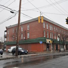
Father Panik Village, Public housing complex in Bridgeport, Connecticut, US.

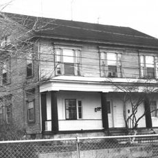
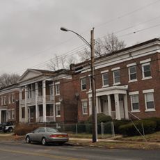
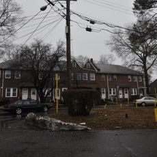
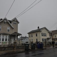
Father Panik Village was a public housing complex in Bridgeport containing 47 brick buildings that housed around 5,400 residents. The development spread across 40 acres near the Yellow Mill River.

The project opened in 1940 as Yellow Mill Village and was renamed in 1955 to honor the Slovak priest who secured federal funding. Father Stephen Panik was instrumental in obtaining the resources that made this pioneering housing development possible.

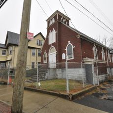
The complex was connected to Saints Cyril and Methodius Parish, and Martin Luther King Drive served as its main street. These names reflect the religious heritage and community structure that shaped daily life in the neighborhood.

The site was accessible via Metro North train tracks on the northern edge and bus service on Crescent Avenue, helping residents reach nearby manufacturing facilities. Transportation connections were crucial to how the community functioned daily.

This was Connecticut's first public housing project, receiving around 6.5 million dollars in federal funding through a priest's determined advocacy. The initiative demonstrated how church leadership could shape federal spending decisions for affordable housing during that era.

The community of curious travelers

AroundUs brings together thousands of curated places, local tips, and hidden gems, enriched daily by 60,000 contributors worldwide.

Start exploring
Location
GPS coordinates
41.18390,-73.17500
Latest update
December 10, 2025 16:02
Around this place
Total Mortgage Arena
United States of America

Total Mortgage Arena

1.6 km
Barnum Museum
United States of America

Barnum Museum

1.5 km
Mary and Eliza Freeman Houses
United States of America

Mary and Eliza Freeman Houses

1.9 km
Pequonnock River Railroad Bridge
United States of America

Pequonnock River Railroad Bridge

959 m
Fairfield County Courthouse
United States of America

Fairfield County Courthouse

1.4 km
Elmer S. Dailey
United States of America

Elmer S. Dailey

1.2 km
East Main Street Historic District
United States of America

East Main Street Historic District

513 m
Priscilla Dailey
United States of America

Priscilla Dailey

1.2 km
Berkshire No. 7
United States of America

Berkshire No. 7

1.2 km
Grand Street Bridge
United States of America

Grand Street Bridge

1.4 km
Bridgeport Downtown South Historic District
United States of America

Bridgeport Downtown South Historic District

1.6 km
United States Post Office–Bridgeport Main
United States of America

United States Post Office–Bridgeport Main

1.2 km
Bridgeport Downtown North Historic District
United States of America

Bridgeport Downtown North Historic District

1.9 km
Sterling Hill Historic District
United States of America

Sterling Hill Historic District

472 m
Lakeview Village Historic District
United States of America

Lakeview Village Historic District

1.5 km
East Bridgeport Historic District
United States of America

East Bridgeport Historic District

796 m
East Washington Avenue Bridge
United States of America

East Washington Avenue Bridge

1.2 km
Connecticut Railway and Lighting Company Car Barn
United States of America

Connecticut Railway and Lighting Company Car Barn

1.1 km
Eagle's Nest
United States of America

Eagle's Nest

1.4 km
Remington City Historic District
United States of America

Remington City Historic District

1.5 km
Golden Hill Historic District
United States of America

Golden Hill Historic District

1.6 km
Bridgeport City Hall
United States of America

Bridgeport City Hall

1.6 km
Ein Jacob Synagogue
United States of America

Ein Jacob Synagogue

981 m
Gateway Village Historic District
United States of America

Gateway Village Historic District

1.4 km
Deacon's Point Historic District
United States of America

Deacon's Point Historic District

407 m
Loew's Majestic Theatre
United States of America

Loew's Majestic Theatre

1.3 km
Loew's Palace Theatre
United States of America

Loew's Palace Theatre

1.3 km
Yellow Mill Bridge
United States of America

Yellow Mill Bridge

810 m
Show the full map
Reviews
Share your experience

No review yet

Discussions
Start a discussion...

No discussion yet

« Father Panik Village - Public housing complex in Bridgeport, Connecticut, US » is provided by Around Us (aroundus.com). Images and texts are derived from Wikimedia project under a Creative Commons license. You are allowed to copy, distribute, and modify copies of this page, under the conditions set by the license, as long as this note is clearly visible.

Discover hidden gems everywhere you go!

From secret cafés to breathtaking viewpoints, skip the crowded tourist spots and find places that match your style. Our app makes it easy with voice search, smart filtering, route optimization, and insider tips from travelers worldwide. Download now for the complete mobile experience.

Around Us App Screenshot

A unique approach to discovering new places

Le Figaro

All the places worth exploring

France Info

A tailor-made excursion in just a few clicks

20 Minutes

Around Us
Travel Guide & Maps
Download

Send to your phone

QR Code
1

Open the camera app on your mobile.

2

Point at the QR code with your camera. A notification will appear.

3

Tap the notification to open the link.