Enable Location

We need your location to show you interesting places around you

Discover nearby places

Find interesting locations and hidden gems around you

Precise directions

Get accurate directions and distances to places

Your location is never shared with other users. It's only used when you tap the location button.

Glocester Town Pound

Log in to your account

Start exploring — it's free

Trusted by 62,563 travelers worldwide

Continue with Google
Continue with Apple
or

We will send you a code to connect

By continuing, you accept our Terms and Conditions and our Privacy Policy

Check your inbox

We've sent a pincode in your inbox. Please enter the code below.

Glocester Town Pound

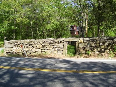
Glocester Town Pound is a stone animal enclosure built around 1749 in Rhode Island and is believed to be the oldest still standing in the United States. The structure spans approximately 50 feet wide with roughly 6-foot-tall walls made of rounded, rough-cut stones, a flat stone top, and a narrow iron gate at the entrance.

The pound was built around 1749 when settlers struggled with stray animals and needed a secure enclosure to hold livestock until owners could claim them. In 1970, the structure was added to the National Register of Historic Places, recognizing its importance as one of America's oldest buildings of this kind.

The pound was an important community effort of early settlers, showing how towns worked together to solve practical problems with livestock. The term "pound" is less common today, replaced by modern words like "animal shelter", but the physical structure reminds visitors of how communities cared for stray animals in colonial times.

The structure sits in a quiet rural setting near Pound Road and is easily accessible for visitors wanting to explore the area. Visitors should note it is an open-air outdoor structure with no roof, so it is best seen during favorable weather conditions.

The structure has a slightly trapezoidal shape due to its placement at a road fork, showing how builders adapted to the landscape rather than forcing a standard design. This practical adjustment to local geography sets it apart from other early pounds in New England.

The community of curious travelers

AroundUs brings together thousands of curated places, local tips, and hidden gems, enriched daily by 60,000 contributors worldwide.

Start exploring
Location
GPS coordinates
41.89556,-71.66917
Latest update
February 9, 2026 07:41
Around this place
Jerimoth Hill
United States of America

Jerimoth Hill

10.5 km
Chace Athletic Center
United States of America

Chace Athletic Center

11.1 km
Beirne Stadium
United States of America

Beirne Stadium

11.3 km
Snake Den State Park
United States of America

Snake Den State Park

13.1 km
Swamp Meadow Bridge
United States of America

Swamp Meadow Bridge

11.8 km
Quaddick State Park
United States of America

Quaddick State Park

13.6 km
Smith-Appleby House
United States of America

Smith-Appleby House

12.5 km
Smithfield Exchange Bank
United States of America

Smithfield Exchange Bank

9.9 km
Clayville Historic District
United States of America

Clayville Historic District

13.2 km
Hopkins Mill Historic District
United States of America

Hopkins Mill Historic District

8.7 km
Pascoag Grammar School
United States of America

Pascoag Grammar School

8 km
Bridgeton School
United States of America

Bridgeton School

8.5 km
Moses Taft House
United States of America

Moses Taft House

8.8 km
Waterman-Winsor Farm
United States of America

Waterman-Winsor Farm

9 km
North Smithfield Public Library
United States of America

North Smithfield Public Library

13.7 km
Josephine White Block
United States of America

Josephine White Block

10.7 km
Brown Avenue Historic District
United States of America

Brown Avenue Historic District

12 km
William Mowry House
United States of America

William Mowry House

10.8 km
Stephen Winsor House
United States of America

Stephen Winsor House

7.9 km
Dexter Arnold Farmstead
United States of America

Dexter Arnold Farmstead

8.8 km
Cornell-Randall-Bailey Roadhouse
United States of America

Cornell-Randall-Bailey Roadhouse

11.6 km
Eddy Homestead
United States of America

Eddy Homestead

12.2 km
Amos Cooke House
United States of America

Amos Cooke House

9.7 km
Battey-Barden House
United States of America

Battey-Barden House

12.3 km
Esten-Bowen House
United States of America

Esten-Bowen House

12.4 km
Harrisville Historic District
United States of America

Harrisville Historic District

7.9 km
Manton-Hunt-Farnum Farm
United States of America

Manton-Hunt-Farnum Farm

4 km
Foster Center Historic District
United States of America

Foster Center Historic District

13 km
Show the full map
« Glocester Town Pound » is provided by Around Us (aroundus.com). Images and texts are derived from Wikimedia project under a Creative Commons license. You are allowed to copy, distribute, and modify copies of this page, under the conditions set by the license, as long as this note is clearly visible.

Discover hidden gems everywhere you go!

From secret cafés to breathtaking viewpoints, skip the crowded tourist spots and find places that match your style. Our app makes it easy with voice search, smart filtering, route optimization, and insider tips from travelers worldwide. Download now for the complete mobile experience.

Around Us App Screenshot

A unique approach to discovering new places

Le Figaro

All the places worth exploring

France Info

A tailor-made excursion in just a few clicks

20 Minutes

Around Us
Travel Guide & Maps
Download

Send to your phone

QR Code
1

Open the camera app on your mobile.

2

Point at the QR code with your camera. A notification will appear.

3

Tap the notification to open the link.