Enable Location

We need your location to show you interesting places around you

Discover nearby places

Find interesting locations and hidden gems around you

Precise directions

Get accurate directions and distances to places

Your location is never shared with other users. It's only used when you tap the location button.

Swamp Meadow Bridge

Log in to your account

Start exploring — it's free

Trusted by 62,561 travelers worldwide

Continue with Google
Continue with Apple
or

We will send you a code to connect

By continuing, you accept our Terms and Conditions and our Privacy Policy

Check your inbox

We've sent a pincode in your inbox. Please enter the code below.

Swamp Meadow Bridge

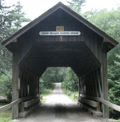
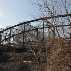
Swamp Meadow Bridge, Covered bridge in Foster, Rhode Island, US.

Swamp Meadow Bridge is a wooden road bridge in Foster that crosses Hemlock Brook and uses a traditional lattice truss design. The structure features diamond-shaped openings along its sides and rests on concrete supports.

The original structure was destroyed in 1993, but the community launched a campaign to rebuild it. The current bridge was constructed in 1994 through the efforts of local residents.

The structure represents local craftsmanship and how communities work to keep traditional covered bridge design alive. You can see how wood construction meets practical modern needs in the design.

The crossing is designed for vehicle passage and has a solid surfaced deck. You can walk across or drive over it, but watch for the narrow width if driving a large vehicle.

The two diamond-shaped windows on each side were a practical design to let light inside. This detail shows how function and aesthetics came together in the original planning.

The community of curious travelers

AroundUs brings together thousands of curated places, local tips, and hidden gems, enriched daily by 60,000 contributors worldwide.

Start exploring
Location
Inception
1994
GPS coordinates
41.79957,-71.72943
Latest update
December 13, 2025 12:24
Unusual Rhode Island attractions to visit

Rhode Island appeals to travelers curious about places often left out of main routes. Along the coast, several lighthouses show the area's maritime history: the Beavertail Lighthouse Museum in Jamestown tells the story of sailors through its optical instruments, while the Southeast Lighthouse on...

Around this place
Jerimoth Hill
United States of America

Jerimoth Hill

6.9 km
Dayville Historic District
United States of America

Dayville Historic District

13.9 km
Old Furnace State Park
United States of America

Old Furnace State Park

11.6 km
Rice City Historic District
United States of America

Rice City Historic District

10.4 km
Isaac Bowen House
United States of America

Isaac Bowen House

9.6 km
Quinebaug Mill – Quebec Square Historic District
United States of America

Quinebaug Mill – Quebec Square Historic District

13.3 km
Broad Street – Davis Park Historic District
United States of America

Broad Street – Davis Park Historic District

12.6 km
Glen Falls Bridge
United States of America

Glen Falls Bridge

14.3 km
Glocester Town Pound
United States of America

Glocester Town Pound

11.8 km
Clayville Historic District
United States of America

Clayville Historic District

5.1 km
Hopkins Mill Historic District
United States of America

Hopkins Mill Historic District

3.2 km
Daniel's Village Archeological Site
United States of America

Daniel's Village Archeological Site

13.7 km
Temple Beth Israel
United States of America

Temple Beth Israel

12.3 km
Danielson Main Street Historic District
United States of America

Danielson Main Street Historic District

12.9 km
Mount Vernon Tavern
United States of America

Mount Vernon Tavern

7.8 km
Elliottville Lower Mill
United States of America

Elliottville Lower Mill

10.4 km
Josephine White Block
United States of America

Josephine White Block

6.1 km
William Waterman House
United States of America

William Waterman House

10.9 km
Moosup Valley Historic District
United States of America

Moosup Valley Historic District

7 km
Dexter Arnold Farmstead
United States of America

Dexter Arnold Farmstead

5.7 km
Amos Cooke House
United States of America

Amos Cooke House

5.7 km
Capt. George Dorrance House
United States of America

Capt. George Dorrance House

8.2 km
Battey-Barden House
United States of America

Battey-Barden House

9.2 km
Wilson-Winslow House
United States of America

Wilson-Winslow House

13.3 km
Joseph Briggs House
United States of America

Joseph Briggs House

13.9 km
Manton-Hunt-Farnum Farm
United States of America

Manton-Hunt-Farnum Farm

14.2 km
Foster Center Historic District
United States of America

Foster Center Historic District

1.8 km
Scituate Reservoir
United States of America

Scituate Reservoir

10.3 km
Show the full map
« Swamp Meadow Bridge - Covered bridge in Foster, Rhode Island, US » is provided by Around Us (aroundus.com). Images and texts are derived from Wikimedia project under a Creative Commons license. You are allowed to copy, distribute, and modify copies of this page, under the conditions set by the license, as long as this note is clearly visible.

Discover hidden gems everywhere you go!

From secret cafés to breathtaking viewpoints, skip the crowded tourist spots and find places that match your style. Our app makes it easy with voice search, smart filtering, route optimization, and insider tips from travelers worldwide. Download now for the complete mobile experience.

Around Us App Screenshot

A unique approach to discovering new places

Le Figaro

All the places worth exploring

France Info

A tailor-made excursion in just a few clicks

20 Minutes

Around Us
Travel Guide & Maps
Download

Send to your phone

QR Code
1

Open the camera app on your mobile.

2

Point at the QR code with your camera. A notification will appear.

3

Tap the notification to open the link.