Enable Location

We need your location to show you interesting places around you

Discover nearby places

Find interesting locations and hidden gems around you

Precise directions

Get accurate directions and distances to places

Your location is never shared with other users. It's only used when you tap the location button.

Hanging Rock and Wabash Reef National Natural Landmark

Log in to your account

Start exploring — it's free

Trusted by 63,652 travelers worldwide

Continue with Google
Continue with Apple
or

We will send you a code to connect

By continuing, you accept our Terms and Conditions and our Privacy Policy

Check your inbox

We've sent a pincode in your inbox. Please enter the code below.

Hanging Rock and Wabash Reef National Natural Landmark
Discussion Reviews 1 Photos
2.4k Popularity

Hanging Rock and Wabash Reef National Natural Landmark, Natural landmark in Wabash County, United States

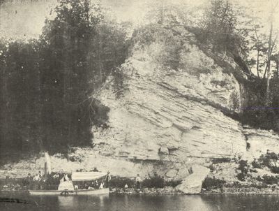
Hanging Rock and Wabash Reef is a natural formation in Indiana that rises 75 feet (23 m) above the Wabash River and displays a fossilized coral reef from the Silurian Period. The 4-acre site shows a limestone structure with a wide base spanning roughly 200 feet (61 m) along the river's edge.

The rock formation dates back to the Silurian Period, roughly 420 million years ago, revealing an ancient ocean environment that once covered this region. The site received National Natural Landmark protection in 1986 to preserve this significant geological location.

Local indigenous groups and early settlers recognized this rock as an important landmark for navigation along the river. People relied on it for finding their way through the valley for centuries.

A short trail of roughly 0.2 miles loops around the base of the rock and is open from sunrise to sunset for visitors to explore. The site is managed by Acres Land Trust, which provides on-site information and guidance for those exploring the landmark.

The top of the rock formation overhangs dramatically due to river erosion, jutting roughly 65 feet above the Wabash Valley floor. This unusual shape made it a recognizable landmark that people noticed and used as a vantage point long before it received official protection.

The community of curious travelers

AroundUs brings together thousands of curated places, local tips, and hidden gems, enriched daily by 60,000 contributors worldwide.

Start exploring
Location
GPS coordinates
40.83000,-85.70720
Latest update
December 8, 2025 21:09
Around this place
United States Vice Presidential Museum
United States of America

United States Vice Presidential Museum

18.8 km
Lincoln Monument of Wabash, Indiana
United States of America

Lincoln Monument of Wabash, Indiana

10.2 km
Salamonie River State Forest
United States of America

Salamonie River State Forest

2 km
St. Patrick's Roman Catholic Church
United States of America

St. Patrick's Roman Catholic Church

2 km
First Christian Church
United States of America

First Christian Church

10.3 km
Huntington Courthouse Square Historic District
United States of America

Huntington Courthouse Square Historic District

18.8 km
North Manchester Covered Bridge
United States of America

North Manchester Covered Bridge

19.1 km
Honeywell Studio
United States of America

Honeywell Studio

12.6 km
William Street School
United States of America

William Street School

18.7 km
Taylor-Zent House
United States of America

Taylor-Zent House

18.7 km
David Alonzo and Elizabeth Purviance House
United States of America

David Alonzo and Elizabeth Purviance House

18.7 km
East Wabash Historic District
United States of America

East Wabash Historic District

9.9 km
Downtown Wabash Historic District
United States of America

Downtown Wabash Historic District

10.3 km
Drover Town Historic District
United States of America

Drover Town Historic District

18.7 km
St. Peter's First Community Church
United States of America

St. Peter's First Community Church

18.7 km
LaFontaine Historic District
United States of America

LaFontaine Historic District

17.4 km
James M. Amoss Building
United States of America

James M. Amoss Building

10.2 km
Solomon Wilson Building
United States of America

Solomon Wilson Building

10.2 km
Teague Barn Wabash Importing Company Farm Stable
United States of America

Teague Barn Wabash Importing Company Farm Stable

15.7 km
Old Plat Historic District
United States of America

Old Plat Historic District

19.1 km
Samuel Purviance House
United States of America

Samuel Purviance House

18.9 km
McNamee-Ford House
United States of America

McNamee-Ford House

10 km
Rangeline Road Bridge
United States of America

Rangeline Road Bridge

14.9 km
Hawley Heights Historic District
United States of America

Hawley Heights Historic District

18.2 km
Victory Noll-St. Felix Friary Historic District
United States of America

Victory Noll-St. Felix Friary Historic District

17.3 km
Young-Yentes-Mattern Farm
United States of America

Young-Yentes-Mattern Farm

9.5 km
Forks of the Wabash
United States of America

Forks of the Wabash

15.6 km
North Jefferson Street Historic District
United States of America

North Jefferson Street Historic District

18.6 km
Show the full map
Reviews
Share your experience

No review yet

Discussions
Start a discussion...

No discussion yet

« Hanging Rock and Wabash Reef National Natural Landmark - Natural landmark in Wabash County, United States » is provided by Around Us (aroundus.com). Images and texts are derived from Wikimedia project under a Creative Commons license. You are allowed to copy, distribute, and modify copies of this page, under the conditions set by the license, as long as this note is clearly visible.

Discover hidden gems everywhere you go!

From secret cafés to breathtaking viewpoints, skip the crowded tourist spots and find places that match your style. Our app makes it easy with voice search, smart filtering, route optimization, and insider tips from travelers worldwide. Download now for the complete mobile experience.

Around Us App Screenshot

A unique approach to discovering new places

Le Figaro

All the places worth exploring

France Info

A tailor-made excursion in just a few clicks

20 Minutes

Around Us
Travel Guide & Maps
Download

Send to your phone

QR Code
1

Open the camera app on your mobile.

2

Point at the QR code with your camera. A notification will appear.

3

Tap the notification to open the link.