Salamonie River State Forest

Log in to your account

14M+
places
190+
countries
Save your favorite places
Create custom travel routes
Rate and review places
Access the full interactive map
Continue with Google
Continue with Apple
Continue with email
By continuing, you accept our Terms and Conditions and our Privacy Policy
Create an account

Salamonie River State Forest

Add to collection
Map
Suggest a change
Share

Salamonie River State Forest, State forest in Wabash and Huntington counties, Indiana, United States.

Salamonie River State Forest is a protected natural area covering roughly 850 acres (344 hectares) across two counties, extending along river bluffs with dense woodlands and walking trails. The property includes a lake and offers varied habitats for native plants and wildlife.

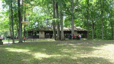
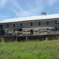
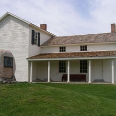
The property began as erodable land purchased by the state in the 1930s with help from local residents who supported land conservation. A building structure constructed during that era of restoration work later gained national historic recognition.

The name comes from a Native American language and refers to yellow dye made from bloodroot plants that grow near the riverbanks. The vegetation here shows how indigenous people once used natural materials from the landscape.

The forest has two camping areas with a combined total of 36 sites and water facilities for visitors. The property offers separate sections for families and horse riders to serve different groups comfortably.

A shelter house on the property was built by a federal work program in the 1930s and was listed in the national register of historic places in 1994. The building represents the craftsmanship from a major historical work initiative.

Location: Indiana

GPS coordinates: 40.81330,-85.69920

Latest update: December 12, 2025 17:46

Photos
Around this place
United States Vice Presidential Museum
United States of America

United States Vice Presidential Museum

18.9 km
Lincoln Monument of Wabash, Indiana
United States of America

Lincoln Monument of Wabash, Indiana

10.4 km
Honeywell Center
United States of America

Honeywell Center

10.8 km
Hanging Rock and Wabash Reef National Natural Landmark
United States of America

Hanging Rock and Wabash Reef National Natural Landmark

2 km
St. Patrick's Roman Catholic Church
United States of America

St. Patrick's Roman Catholic Church

3.7 km
First Christian Church
United States of America

First Christian Church

10.5 km
Huntington Courthouse Square Historic District
United States of America

Huntington Courthouse Square Historic District

18.8 km
Honeywell Studio
United States of America

Honeywell Studio

13.4 km
William Street School
United States of America

William Street School

18.6 km
Taylor-Zent House
United States of America

Taylor-Zent House

18.8 km
David Alonzo and Elizabeth Purviance House
United States of America

David Alonzo and Elizabeth Purviance House

18.8 km
Hominy Ridge Shelter House
United States of America

Hominy Ridge Shelter House

1.4 km
East Wabash Historic District
United States of America

East Wabash Historic District

10.1 km
Downtown Wabash Historic District
United States of America

Downtown Wabash Historic District

10.5 km
Drover Town Historic District
United States of America

Drover Town Historic District

18.7 km
St. Peter's First Community Church
United States of America

St. Peter's First Community Church

18.7 km
LaFontaine Historic District
United States of America

LaFontaine Historic District

15.6 km
James M. Amoss Building
United States of America

James M. Amoss Building

10.4 km
Solomon Wilson Building
United States of America

Solomon Wilson Building

10.4 km
Teague Barn Wabash Importing Company Farm Stable
United States of America

Teague Barn Wabash Importing Company Farm Stable

15.7 km
Old Plat Historic District
United States of America

Old Plat Historic District

19.1 km
Samuel Purviance House
United States of America

Samuel Purviance House

18.9 km
McNamee-Ford House
United States of America

McNamee-Ford House

10.3 km
Rangeline Road Bridge
United States of America

Rangeline Road Bridge

15.1 km
Hawley Heights Historic District
United States of America

Hawley Heights Historic District

18.4 km
Victory Noll-St. Felix Friary Historic District
United States of America

Victory Noll-St. Felix Friary Historic District

17.5 km
Young-Yentes-Mattern Farm
United States of America

Young-Yentes-Mattern Farm

10.5 km
Forks of the Wabash
United States of America

Forks of the Wabash

15.7 km
Show the full map
Reviews

Visited this place? Tap the stars to rate it and share your experience / photos with the community! Try now! You can cancel it anytime.

« Salamonie River State Forest - State forest in Wabash and Huntington counties, Indiana, United States » is provided by Around Us (aroundus.com). Images and texts are derived from Wikimedia project under a Creative Commons license. You are allowed to copy, distribute, and modify copies of this page, under the conditions set by the license, as long as this note is clearly visible.

Discover hidden gems everywhere you go!

From secret cafés to breathtaking viewpoints, skip the crowded tourist spots and find places that match your style. Our app makes it easy with voice search, smart filtering, route optimization, and insider tips from travelers worldwide. Download now for the complete mobile experience.

Around Us App Screenshot

A unique approach to discovering new places

Le Figaro

All the places worth exploring

France Info

A tailor-made excursion in just a few clicks

20 Minutes