Enable Location

We need your location to show you interesting places around you

Discover nearby places

Find interesting locations and hidden gems around you

Precise directions

Get accurate directions and distances to places

Your location is never shared with other users. It's only used when you tap the location button.

Log in to your account

Start exploring — it's free

Trusted by 69,368 travelers worldwide

Continue with Google
Continue with Apple
or

We will send you a code to connect

By continuing, you accept our Terms and Conditions and our Privacy Policy

Check your inbox

We've sent a pincode in your inbox. Please enter the code below.

Herman Gardens
Discussion Reviews Photo
8.4k Popularity

Herman Gardens, Public housing complex in northwest Detroit, US

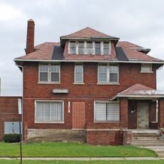
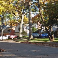
Herman Gardens was a public housing development in northwest Detroit, made up of two-story brick buildings arranged across a large site at the corner of Joy Road and Southfield Freeway. The complex originally held around 2,100 residential units grouped into multiple blocks.

The complex was built in 1943 to address a housing shortage in Detroit caused by the rapid growth of wartime industry. It remained one of the largest housing projects in the city for over six decades before being demolished.

Herman Gardens housed families from many different walks of life, and its presence shaped how the northwest Detroit community came together over generations. The name lives on in Gardenview Estates, the development that replaced it and continues to serve the same neighborhood.

The site is located at a busy intersection in northwest Detroit and can be reached by public transit. Since this is now a residential area, visitors should move through calmly and be considerate of the people who live there.

After demolition, the land was redeveloped into Gardenview Estates, a mixed-income housing project that also includes a Boys and Girls Club youth center on the same grounds. This makes it one of the few cases in Detroit where a former housing project was fully replaced by new construction open to residents of different income levels.

The community of curious travelers

AroundUs brings together thousands of curated places, local tips, and hidden gems, enriched daily by 60,000 contributors worldwide.

Start exploring
GPS coordinates
42.35389,-83.21139
Latest update
March 3, 2026 10:11
Around this place
The Henry Ford
United States of America

The Henry Ford

5.9 km
Fair Lane
United States of America

Fair Lane

4.7 km
Islamic Center of America
United States of America

Islamic Center of America

3 km
Automotive Hall of Fame
United States of America

Automotive Hall of Fame

6.1 km
Uniroyal Giant Tire
United States of America

Uniroyal Giant Tire

9.3 km
Grande Ballroom
United States of America

Grande Ballroom

6.9 km
Ford Rotunda
United States of America

Ford Rotunda

5.5 km
Lee Plaza
United States of America

Lee Plaza

9 km
Redford Theatre
United States of America

Redford Theatre

8 km
Arab American National Museum
United States of America

Arab American National Museum

4.5 km
Dearborn Mosque
United States of America

Dearborn Mosque

7.8 km
Shrine of the Black Madonna
United States of America

Shrine of the Black Madonna

9.1 km
Lincoln Motor Company Plant
United States of America

Lincoln Motor Company Plant

6.8 km
St. Theresa of Avila Roman Catholic Church
United States of America

St. Theresa of Avila Roman Catholic Church

7.6 km
Commandant's Quarters
United States of America

Commandant's Quarters

5.9 km
Ford Rouge Factory Tour
United States of America

Ford Rouge Factory Tour

6 km
Rosa Parks Flat
United States of America

Rosa Parks Flat

8.4 km
Gethsemane Evangelical Lutheran Church
United States of America

Gethsemane Evangelical Lutheran Church

8.5 km
Henry Ford Centennial Library
United States of America

Henry Ford Centennial Library

4.6 km
Ford Drive-In
United States of America

Ford Drive-In

5.1 km
Senate Theater
United States of America

Senate Theater

7.7 km
Fort Street–Pleasant Street and Norfolk & Western Railroad Viaduct
United States of America

Fort Street–Pleasant Street and Norfolk & Western Railroad Viaduct

9.3 km
US 12 Bridges
United States of America

US 12 Bridges

5.2 km
Dearborn City Hall Complex
United States of America

Dearborn City Hall Complex

4.6 km
Nacirema Club
United States of America

Nacirema Club

7.9 km
Springwells Park Historic District
United States of America

Springwells Park Historic District

5.3 km
Saint Clement of Ohrid Macedono-Bulgarian Eastern Orthodox Church (Dearborn, Michigan)
United States of America

Saint Clement of Ohrid Macedono-Bulgarian Eastern Orthodox Church (Dearborn, Michigan)

3.1 km
Automotive Hall of Fame
United States of America

Automotive Hall of Fame

6.1 km
Show the full map
Reviews
Share your experience

No review yet

Discussions
Start a discussion...

No discussion yet

« Herman Gardens - Public housing complex in northwest Detroit, US » is provided by Around Us (aroundus.com). Images and texts are derived from Wikimedia project under a Creative Commons license. You are allowed to copy, distribute, and modify copies of this page, under the conditions set by the license, as long as this note is clearly visible.

Discover hidden gems everywhere you go!

From secret cafés to breathtaking viewpoints, skip the crowded tourist spots and find places that match your style. Our app makes it easy with voice search, smart filtering, route optimization, and insider tips from travelers worldwide. Download now for the complete mobile experience.

Around Us App Screenshot

A unique approach to discovering new places

Le Figaro

All the places worth exploring

France Info

A tailor-made excursion in just a few clicks

20 Minutes

Around Us
Travel Guide & Maps
Download

Send to your phone

QR Code
1

Open the camera app on your mobile.

2

Point at the QR code with your camera. A notification will appear.

3

Tap the notification to open the link.