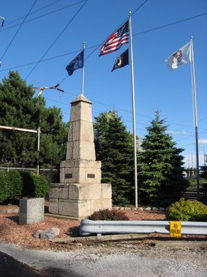
Illinois-Indiana State Line Boundary Marker, Sandstone boundary marker in Hammond, United States.
The Illinois-Indiana State Line Boundary Marker is a solid obelisk made of sandstone blocks that marks the exact border between two states. The structure consists of stacked stone layers that clearly indicate where the two territories meet.
The Office of the United States Surveyor General built this boundary marker in 1838. It stands as one of the oldest structures from this early surveying period.
The marker represents how settlers divided and measured the land between two states. Visitors can see a physical symbol of these early administrative boundaries.
The marker is located near Avenue G and 103rd Street and can be easily found in the area. Visitors should know that this outdoor monument is accessible at any time of day.
In 1988 the marker was moved about 191 feet north but stayed directly on the state line. This relocation shows how surveyors corrected boundary positions over time to ensure greater accuracy.
The community of curious travelers
AroundUs brings together thousands of curated places, local tips, and hidden gems, enriched daily by 60,000 contributors worldwide.