Enable Location

We need your location to show you interesting places around you

Discover nearby places

Find interesting locations and hidden gems around you

Precise directions

Get accurate directions and distances to places

Your location is never shared with other users. It's only used when you tap the location button.

Jack's Creek Covered Bridge

Log in to your account

Start exploring — it's free

Trusted by 61,944 travelers worldwide

Continue with Google
Continue with Apple
or

We will send you a code to connect

By continuing, you accept our Terms and Conditions and our Privacy Policy

Check your inbox

We've sent a pincode in your inbox. Please enter the code below.

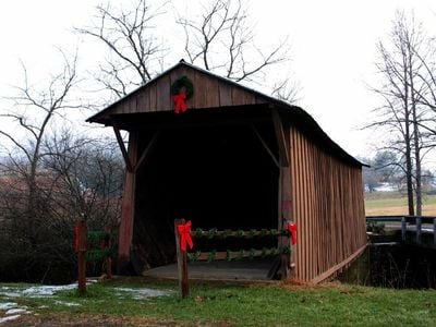
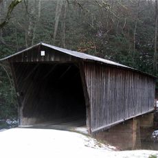
Jack's Creek Covered Bridge, Covered bridge over Smith River in Woolwine, United States

Jack's Creek Covered Bridge is a wooden structure that crosses the Smith River with a queen post truss design and dates from the early twentieth century. The bridge connects both riverbanks with its characteristic enclosed construction of wooden beams.

The bridge was built in 1914 by Charlie Elam Vaughn using oak wood to provide access to Jack's Creek Primitive Baptist Church. It survived the destructive 2015 floods that damaged other nearby bridges, becoming the sole remaining example of its kind in Patrick County.

The bridge functions as a distinctive wooden passageway that people cross on foot, its enclosed timber structure creating a memorable experience of moving through a historic structure rather than simply crossing water.

The bridge is located on Jack's Creek Road near State Route 8 and remains open to pedestrians who can sign the visitor guest book. Access is straightforward, and visitors should expect slippery conditions when the wooden surfaces are wet.

The bridge survived a series of flooding events that destroyed other wooden bridges in the region, making it a rare survivor of this building style. Visitors can observe how the original oak wood and hand-crafted construction have withstood over a century of use.

The community of curious travelers

AroundUs brings together thousands of curated places, local tips, and hidden gems, enriched daily by 60,000 contributors worldwide.

Start exploring
Location
Inception
1914
GPS coordinates
36.76431,-80.27356
Latest update
December 14, 2025 17:42
Around this place
Fairy Stone State Park
United States of America

Fairy Stone State Park

17.1 km
Philpott Dam
United States of America

Philpott Dam

22 km
Reynolds Homestead
United States of America

Reynolds Homestead

17.4 km
Buffalo Mountain Natural Area Preserve
United States of America

Buffalo Mountain Natural Area Preserve

18.5 km
Bob White Covered Bridge
United States of America

Bob White Covered Bridge

2.8 km
Bugbook Historical Computer Museum
United States of America

Bugbook Historical Computer Museum

16.8 km
Buffalo Mountain Presbyterian Church and Cemetery
United States of America

Buffalo Mountain Presbyterian Church and Cemetery

21.8 km
Cockram Mill
United States of America

Cockram Mill

10 km
Slate Mountain Presbyterian Church and Cemetery
United States of America

Slate Mountain Presbyterian Church and Cemetery

10.7 km
Spring Valley Rural Historic District
United States of America

Spring Valley Rural Historic District

18.7 km
Willis Presbyterian Church and Cemetery
United States of America

Willis Presbyterian Church and Cemetery

21.4 km
Oakdale
United States of America

Oakdale

25.8 km
Floyd Presbyterian Church
United States of America

Floyd Presbyterian Church

16.8 km
Goblintown Mill
United States of America

Goblintown Mill

10.6 km
Barnard Farm
United States of America

Barnard Farm

21.9 km
Aurora
United States of America

Aurora

26.8 km
Glenanna
United States of America

Glenanna

16.9 km
R.L. Stone House
United States of America

R.L. Stone House

25.8 km
Patrick County Courthouse
United States of America

Patrick County Courthouse

13.7 km
Phlegar Farm
United States of America

Phlegar Farm

18.1 km
West Fork Furnace
United States of America

West Fork Furnace

11.9 km
Floyd Historic District
United States of America

Floyd Historic District

16.9 km
Old Turner Place
United States of America

Old Turner Place

25.5 km
Stuart Uptown Historic District
United States of America

Stuart Uptown Historic District

13.7 km
Groundhog Mountain Tower
United States of America

Groundhog Mountain Tower

26.3 km
Mabry Mill
United States of America

Mabry Mill

11.9 km
Rocky Knob Visitor Center
United States of America

Rocky Knob Visitor Center

10.1 km
Rakes Mill Pond
United States of America

Rakes Mill Pond

11.4 km
Show the full map
« Jack's Creek Covered Bridge - Covered bridge over Smith River in Woolwine, United States » is provided by Around Us (aroundus.com). Images and texts are derived from Wikimedia project under a Creative Commons license. You are allowed to copy, distribute, and modify copies of this page, under the conditions set by the license, as long as this note is clearly visible.

Discover hidden gems everywhere you go!

From secret cafés to breathtaking viewpoints, skip the crowded tourist spots and find places that match your style. Our app makes it easy with voice search, smart filtering, route optimization, and insider tips from travelers worldwide. Download now for the complete mobile experience.

Around Us App Screenshot

A unique approach to discovering new places

Le Figaro

All the places worth exploring

France Info

A tailor-made excursion in just a few clicks

20 Minutes

Around Us
Travel Guide & Maps
Download

Send to your phone

QR Code
1

Open the camera app on your mobile.

2

Point at the QR code with your camera. A notification will appear.

3

Tap the notification to open the link.