Enable Location

We need your location to show you interesting places around you

Discover nearby places

Find interesting locations and hidden gems around you

Precise directions

Get accurate directions and distances to places

Your location is never shared with other users. It's only used when you tap the location button.

KMSP Tower

Log in to your account

Start exploring — it's free

Trusted by 62,099 travelers worldwide

Continue with Google
Continue with Apple
or

We will send you a code to connect

By continuing, you accept our Terms and Conditions and our Privacy Policy

Check your inbox

We've sent a pincode in your inbox. Please enter the code below.

KMSP Tower

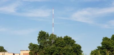
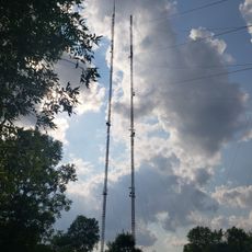
KMSP Tower, Broadcasting tower in Shoreview, United States

KMSP Tower is a broadcasting structure in Shoreview that stands at approximately 1,466 feet (447 meters) and transmits signals for multiple FM radio stations and television channels serving the Minnesota region. The facility is operated by Fox Television Stations and carries programming for KMSP-TV, WFTC, and public television stations KTCA and KTCI.

The structure was completed in 1971 and held the title of Minnesota's tallest building until the KPXM Tower surpassed it in 1997. This long period of prominence established it as a notable landmark in the regional landscape.

The tower is one of three broadcasting structures that shaped Shoreview's municipal symbol, which features vertical lines meant to evoke transmission masts.

The structure sits within Vadnais-Snail Lakes Regional Park, where walking trails allow visitors to approach the tower's base and explore the surrounding landscape. The park setting makes it easy to view this landmark from various vantage points.

The tower held the distinction of being Minnesota's highest structure for 26 years after its completion, a remarkable achievement in the state's construction history. Few visitors realize this building once dominated the region's skyline in ways that shaped how people saw the landscape.

The community of curious travelers

AroundUs brings together thousands of curated places, local tips, and hidden gems, enriched daily by 60,000 contributors worldwide.

Start exploring
Location
GPS coordinates
45.05830,-93.12440
Latest update
December 12, 2025 09:08
Around this place
Como Park Zoo and Conservatory
United States of America

Como Park Zoo and Conservatory

8.8 km
Como Zoo
United States of America

Como Zoo

8.8 km
Luther Seminary
United States of America

Luther Seminary

10 km
Bandana Square
United States of America

Bandana Square

9.9 km
Hollywood Theater
United States of America

Hollywood Theater

9.9 km
Heman Gibbs Farmstead
United States of America

Heman Gibbs Farmstead

8.9 km
Goldstein Museum of Design
United States of America

Goldstein Museum of Design

8.8 km
Norway Lutheran Church
United States of America

Norway Lutheran Church

9.9 km
Tropics Indoor Water Park
United States of America

Tropics Indoor Water Park

2.6 km
Salvation Army Women's Home and Hospital
United States of America

Salvation Army Women's Home and Hospital

9.4 km
Reservoir Woods Park
United States of America

Reservoir Woods Park

6.8 km
Foss House
United States of America

Foss House

7.5 km
Bridges No. L-5853 and 92247
United States of America

Bridges No. L-5853 and 92247

9.1 km
First National Bank of White Bear
United States of America

First National Bank of White Bear

9.6 km
Cyrus B. Cobb House
United States of America

Cyrus B. Cobb House

9.6 km
Casiville Bullard House
United States of America

Casiville Bullard House

8.7 km
Lunds & Byerlys
United States of America

Lunds & Byerlys

6.1 km
Telefarm Towers Shoreview
United States of America

Telefarm Towers Shoreview

1.5 km
E. H. Hobe House-Solheim
United States of America

E. H. Hobe House-Solheim

9.6 km
Jacob Hinkel House
United States of America

Jacob Hinkel House

9.4 km
Maplewood Area Historical Society
United States of America

Maplewood Area Historical Society

9.4 km
Gibbs Farm
United States of America

Gibbs Farm

8.8 km
James J. Hill's North Oaks Farm, Dairy Building
United States of America

James J. Hill's North Oaks Farm, Dairy Building

4 km
Como Park
United States of America

Como Park

9 km
Central Park
United States of America

Central Park

4.6 km
Waite Park
United States of America

Waite Park

9.2 km
Cavell Park
United States of America

Cavell Park

9.7 km
Rice Street Branch Library
United States of America

Rice Street Branch Library

9.8 km
Show the full map
« KMSP Tower - Broadcasting tower in Shoreview, United States » is provided by Around Us (aroundus.com). Images and texts are derived from Wikimedia project under a Creative Commons license. You are allowed to copy, distribute, and modify copies of this page, under the conditions set by the license, as long as this note is clearly visible.

Discover hidden gems everywhere you go!

From secret cafés to breathtaking viewpoints, skip the crowded tourist spots and find places that match your style. Our app makes it easy with voice search, smart filtering, route optimization, and insider tips from travelers worldwide. Download now for the complete mobile experience.

Around Us App Screenshot

A unique approach to discovering new places

Le Figaro

All the places worth exploring

France Info

A tailor-made excursion in just a few clicks

20 Minutes

Around Us
Travel Guide & Maps
Download

Send to your phone

QR Code
1

Open the camera app on your mobile.

2

Point at the QR code with your camera. A notification will appear.

3

Tap the notification to open the link.