·

Enable Location

We need your location to show you interesting places around you

Discover nearby places

Find interesting locations and hidden gems around you

Precise directions

Get accurate directions and distances to places

Your location is never shared with other users. It's only used when you tap the location button.

Lake Allegan

Log in to your account

Start exploring — it's free

Trusted by 62,742 travelers worldwide

Continue with Google
Continue with Apple
or

We will send you a code to connect

By continuing, you accept our Terms and Conditions and our Privacy Policy

Check your inbox

We've sent a pincode in your inbox. Please enter the code below.

Lake Allegan

Lake Allegan, lake in Allegan County, Michigan, United States

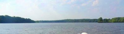
Lake Allegan is a man-made reservoir in Allegan County created by damming the Kalamazoo River at Calkins Dam. The water body spans roughly 1,600 acres and features a mix of wooded shorelines and open areas, with calm surfaces that remain steady throughout the year.

The lake was created by constructing Calkins Dam across the Kalamazoo River and is now operated by Consumers Energy to provide electricity to the area. During World War II, a prisoner of war camp housed German prisoners nearby, and remnants of camp structures still remain visible on the western shoreline today.

The lake takes its name from the nearby city of Allegan and serves as a gathering place for locals and visitors seeking outdoor recreation. People share stories about fishing trips and boat rides, making it part of the community's way of connecting with nature.

The lake is easy to reach from the city of Allegan and is also close to towns like Holland, Saugatuck, and Grand Rapids, making it accessible from different parts of Michigan. Public boat launches on the south side near Monroe Road and access points like Echo Point near 42nd Street allow visitors to enter the water or enjoy views conveniently.

A small uninhabited island on the water is home to turtles and nesting birds that rest on rocks and fallen trees. During spring and fall spawning seasons, salmon move upstream near the dam, drawing fishermen who come specifically for these runs.

The community of curious travelers

AroundUs brings together thousands of curated places, local tips, and hidden gems, enriched daily by 60,000 contributors worldwide.

Start exploring
Location
Elevation above the sea
187 m
GPS coordinates
42.55000,-85.93330
Latest update
February 7, 2026 11:00
Around this place
Kal-Haven Trail
United States of America

Kal-Haven Trail

18.8 km
Second Street Bridge
United States of America

Second Street Bridge

7.5 km
New Richmond Swing Bridge
United States of America

New Richmond Swing Bridge

18.2 km
Oakwood Cemetery Chapel
United States of America

Oakwood Cemetery Chapel

6.4 km
Griswold Civic Center Historic District
United States of America

Griswold Civic Center Historic District

7.1 km
Lake Shore Chapel
United States of America

Lake Shore Chapel

26.1 km
All Saints Episcopal Church
United States of America

All Saints Episcopal Church

24.9 km
Francis Metallic Surfboat
United States of America

Francis Metallic Surfboat

24.5 km
Douglas Union School
United States of America

Douglas Union School

24.5 km
Pritchard's Outlook Historic District
United States of America

Pritchard's Outlook Historic District

6.8 km
Augustus Lilly House
United States of America

Augustus Lilly House

7.4 km
Edward D. Born House
United States of America

Edward D. Born House

7.5 km
Saugatuck Pump House
United States of America

Saugatuck Pump House

25.6 km
Henry Franks House
United States of America

Henry Franks House

6.7 km
Marshall Street Historic District
United States of America

Marshall Street Historic District

8.1 km
Warner P. Sutton House
United States of America

Warner P. Sutton House

24.4 km
Downtown Allegan Historic District
United States of America

Downtown Allegan Historic District

7.3 km
Hacklander Site
United States of America

Hacklander Site

21.1 km
William C. Messenger House
United States of America

William C. Messenger House

7.2 km
West Bridge Street Historic District
United States of America

West Bridge Street Historic District

26.2 km
Engelbert B. Born House
United States of America

Engelbert B. Born House

7.5 km
William H. Brown House
United States of America

William H. Brown House

6.6 km
Sarah Lowe Stedman House
United States of America

Sarah Lowe Stedman House

8.3 km
Singapore, Michigan Historical Marker
United States of America

Singapore, Michigan Historical Marker

25.1 km
First Congregational Church Historical Marker
United States of America

First Congregational Church Historical Marker

25.1 km
Gordon W Lloyd Historical Marker
United States of America

Gordon W Lloyd Historical Marker

24.9 km
J. C. Wheeler Public Library
United States of America

J. C. Wheeler Public Library

24 km
CSX Kalamazoo River Bridge
United States of America

CSX Kalamazoo River Bridge

18.2 km
Show the full map
« Lake Allegan - lake in Allegan County, Michigan, United States » is provided by Around Us (aroundus.com). Images and texts are derived from Wikimedia project under a Creative Commons license. You are allowed to copy, distribute, and modify copies of this page, under the conditions set by the license, as long as this note is clearly visible.

Discover hidden gems everywhere you go!

From secret cafés to breathtaking viewpoints, skip the crowded tourist spots and find places that match your style. Our app makes it easy with voice search, smart filtering, route optimization, and insider tips from travelers worldwide. Download now for the complete mobile experience.

Around Us App Screenshot

A unique approach to discovering new places

Le Figaro

All the places worth exploring

France Info

A tailor-made excursion in just a few clicks

20 Minutes

Around Us
Travel Guide & Maps
Download

Send to your phone

QR Code
1

Open the camera app on your mobile.

2

Point at the QR code with your camera. A notification will appear.

3

Tap the notification to open the link.