Enable Location

We need your location to show you interesting places around you

Discover nearby places

Find interesting locations and hidden gems around you

Precise directions

Get accurate directions and distances to places

Your location is never shared with other users. It's only used when you tap the location button.

L'Enfant Plan

Log in to your account

Start exploring — it's free

Trusted by 61,644 travelers worldwide

Continue with Google
Continue with Apple
or

We will send you a code to connect

By continuing, you accept our Terms and Conditions and our Privacy Policy

Check your inbox

We've sent a pincode in your inbox. Please enter the code below.

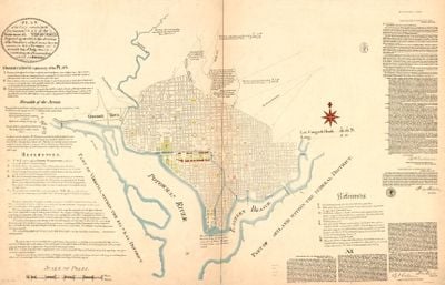
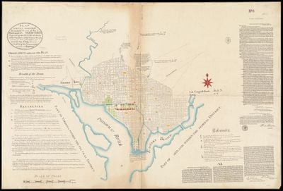
L'Enfant Plan, Urban planning model in Washington D.C., United States

Description

The L'Enfant Plan is an urban design from the late 1700s that organizes Washington, D.C. with broad avenues crossing at different angles to form a geometric pattern. The scheme links major government buildings through spacious thoroughfares and creates several focal points and green areas spread throughout the city.

History

President George Washington hired French architect Pierre Charles L'Enfant in 1791 to design the layout of the new American capital. L'Enfant's vision of a planned city with radiating streets was groundbreaking and his concepts were built into reality.

Culture

The street layout shows how the young nation wanted to organize its government through open public spaces and direct sightlines between key buildings. Walking through the avenues and squares today, you can sense how the design reflects the idea of a government that belongs to the people.

Practical

To understand the plan, start by viewing it from above or take time walking through it to grasp the angles and connections between the avenues. Wear comfortable shoes since you will need to cover considerable distances on foot to see the different sections and how they relate to each other.

Did you know?

The wide ceremonial mall known as the National Mall was deliberately laid out to link government buildings while also creating a central public gathering space. Visitors often miss that this 400-foot-wide area was part of the original design rather than added later.

Location
Inception
1791
GPS coordinates
38.89056,-77.02028
Latest update
December 18, 2025 11:41

AroundUs brings together thousands of curated places, local tips, and hidden gems, enriched daily by 60,000 contributors worldwide. Discover all places nearby (Washington, D.C.).

Around this place
National Mall
United States of America

National Mall

271 m
National Air and Space Museum
United States of America

National Air and Space Museum

249 m
National Gallery of Art
United States of America

National Gallery of Art

96 m
Newseum
United States of America

Newseum

309 m
Spirit of Haida Gwaii
United States of America

Spirit of Haida Gwaii

325 m
National Gallery of Art Sculpture Garden
United States of America

National Gallery of Art Sculpture Garden

250 m
Continuum
United States of America

Continuum

313 m
Kiepenkerl
United States of America

Kiepenkerl

305 m
Federal Trade Commission Building
United States of America

Federal Trade Commission Building

206 m
Army Medical Museum and Library
United States of America

Army Medical Museum and Library

333 m
Man Controlling Trade
United States of America

Man Controlling Trade

203 m
Federal Home Loan Bank Board Building
United States of America

Federal Home Loan Bank Board Building

294 m
Unabomber's cabin
United States of America

Unabomber's cabin

285 m
Are Years What?
United States of America

Are Years What?

329 m
Delta Solar
United States of America

Delta Solar

311 m
Ad Astra
United States of America

Ad Astra

220 m
Lunar Bird
United States of America

Lunar Bird

320 m
Andrew W. Mellon Memorial Fountain
United States of America

Andrew W. Mellon Memorial Fountain

217 m
Bust of Francesco Barberini
United States of America

Bust of Francesco Barberini

104 m
An Entrance to the Paris Métropolitain
United States of America

An Entrance to the Paris Métropolitain

283 m
Guardianship
United States of America

Guardianship

284 m
Heritage
United States of America

Heritage

320 m
Evocation of a Form: Human, Lunar, Spectral
United States of America

Evocation of a Form: Human, Lunar, Spectral

284 m
Central National Bank
United States of America

Central National Bank

310 m
National Gallery of Art - East Building
United States of America

National Gallery of Art - East Building

282 m
Throwback
United States of America

Throwback

323 m
Monsoon Drift
United States of America

Monsoon Drift

328 m
East Wing National Gallery of Art
United States of America

East Wing National Gallery of Art

296 m
Show the full map
« L'Enfant Plan - Urban planning model in Washington D.C., United States » is provided by Around Us (aroundus.com). Images and texts are derived from Wikimedia project under a Creative Commons license. You are allowed to copy, distribute, and modify copies of this page, under the conditions set by the license, as long as this note is clearly visible.

Discover hidden gems everywhere you go!

From secret cafés to breathtaking viewpoints, skip the crowded tourist spots and find places that match your style. Our app makes it easy with voice search, smart filtering, route optimization, and insider tips from travelers worldwide. Download now for the complete mobile experience.

Around Us App Screenshot

A unique approach to discovering new places

Le Figaro

All the places worth exploring

France Info

A tailor-made excursion in just a few clicks

20 Minutes

Around Us
Travel Guide & Maps
Download

Send to your phone

QR Code
1

Open the camera app on your mobile.

2

Point at the QR code with your camera. A notification will appear.

3

Tap the notification to open the link.