Enable Location

We need your location to show you interesting places around you

Discover nearby places

Find interesting locations and hidden gems around you

Precise directions

Get accurate directions and distances to places

Your location is never shared with other users. It's only used when you tap the location button.

Lake Menomin

Log in to your account

Start exploring — it's free

Trusted by 62,558 travelers worldwide

Continue with Google
Continue with Apple
or

We will send you a code to connect

By continuing, you accept our Terms and Conditions and our Privacy Policy

Check your inbox

We've sent a pincode in your inbox. Please enter the code below.

Lake Menomin

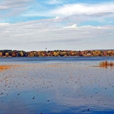
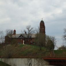
Lake Menomin, reservoir in northwestern Wisconsin

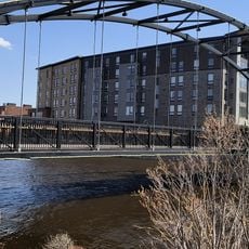
Lake Menomin is a large reservoir in Wisconsin covering over a thousand acres and part of the Red Cedar River system. The water reaches depths of up to 34 feet and is home to panfish, bass, northern pike, and walleye, with multiple public boat landings along the shoreline.

A dam was built on the Red Cedar River in 1886 to control water flow and generate electricity. The structure with its special Tainter gate helped power mills and factories in the area and continues to shape local history today.

The name Lake Menomin comes from the Ojibwe language and means 'Abundant with Wild Rice Lake'. Today, the water and shores serve as gathering places for anglers, boaters, and families who spend their leisure time here.

The water has multiple public boat landings that are easy to find and use, allowing visitors to launch boats, canoes, or kayaks without hassle. Walking paths and green spaces along the shores are suitable for strolling, jogging, or picnicking.

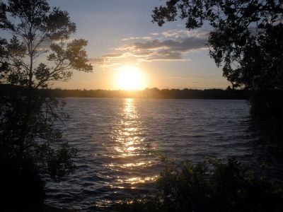
The dam features a special Tainter gate, an invention designed specifically for this type of dam structure. Visitors watching the sunset from nearby cemeteries or parks experience simple but memorable views of the water changing colors at dusk.

The community of curious travelers

AroundUs brings together thousands of curated places, local tips, and hidden gems, enriched daily by 60,000 contributors worldwide.

Start exploring
Location
GPS coordinates
44.89244,-91.91257
Latest update
February 9, 2026 08:22
Around this place
Soo Line 2719
United States of America

Soo Line 2719

32.4 km
Carson Park
United States of America

Carson Park

32.4 km
Tainter Lake
United States of America

Tainter Lake

5.1 km
Hoffman Hills State Recreation Area
United States of America

Hoffman Hills State Recreation Area

12.2 km
Wilson Place Museum
United States of America

Wilson Place Museum

1.7 km
Louis Smith Tainter House
United States of America

Louis Smith Tainter House

2 km
St. Patrick's Church
United States of America

St. Patrick's Church

33.1 km
State Theatre
United States of America

State Theatre

33.7 km
Community House, First Congregational Church
United States of America

Community House, First Congregational Church

33.5 km
Sacred Heart Church
United States of America

Sacred Heart Church

33.6 km
Brady Anderson and Waldemar Ager House
United States of America

Brady Anderson and Waldemar Ager House

32.6 km
Dunnville Barrens State Natural Area
United States of America

Dunnville Barrens State Natural Area

18.1 km
Pepin County Courthouse and Jail
United States of America

Pepin County Courthouse and Jail

29.6 km
Colfax Municipal Building
United States of America

Colfax Municipal Building

18.9 km
Oatman Filling Station
United States of America

Oatman Filling Station

31.6 km
James Stephen Hoover and Elizabeth Borland Memorial Chapel
United States of America

James Stephen Hoover and Elizabeth Borland Memorial Chapel

31.9 km
Eau Claire Public Library
United States of America

Eau Claire Public Library

33.9 km
Levi Merrill House
United States of America

Levi Merrill House

31.6 km
Eau Claire Vocational School
United States of America

Eau Claire Vocational School

33 km
Children’s Museum of Eau Claire
United States of America

Children’s Museum of Eau Claire

33.6 km
Drummond Business Block
United States of America

Drummond Business Block

33.6 km
Barnes Block
United States of America

Barnes Block

33.7 km
Salsbury Row House
United States of America

Salsbury Row House

33.5 km
Confluence Commercial Historic District
United States of America

Confluence Commercial Historic District

33.7 km
Chippewa Valley Museum
United States of America

Chippewa Valley Museum

32.4 km
Wisconsin Logging Museum
United States of America

Wisconsin Logging Museum

32.5 km
Mabel Tainter Center for the Arts
United States of America

Mabel Tainter Center for the Arts

2.1 km
Lutheran Church of the Good Shepherd
United States of America

Lutheran Church of the Good Shepherd

31.6 km
Show the full map
« Lake Menomin - reservoir in northwestern Wisconsin » is provided by Around Us (aroundus.com). Images and texts are derived from Wikimedia project under a Creative Commons license. You are allowed to copy, distribute, and modify copies of this page, under the conditions set by the license, as long as this note is clearly visible.

Discover hidden gems everywhere you go!

From secret cafés to breathtaking viewpoints, skip the crowded tourist spots and find places that match your style. Our app makes it easy with voice search, smart filtering, route optimization, and insider tips from travelers worldwide. Download now for the complete mobile experience.

Around Us App Screenshot

A unique approach to discovering new places

Le Figaro

All the places worth exploring

France Info

A tailor-made excursion in just a few clicks

20 Minutes

Around Us
Travel Guide & Maps
Download

Send to your phone

QR Code
1

Open the camera app on your mobile.

2

Point at the QR code with your camera. A notification will appear.

3

Tap the notification to open the link.