Enable Location

We need your location to show you interesting places around you

Discover nearby places

Find interesting locations and hidden gems around you

Precise directions

Get accurate directions and distances to places

Your location is never shared with other users. It's only used when you tap the location button.

Lewis and Clark State Park

Log in to your account

Start exploring — it's free

Trusted by 63,414 travelers worldwide

Continue with Google
Continue with Apple
or

We will send you a code to connect

By continuing, you accept our Terms and Conditions and our Privacy Policy

Check your inbox

We've sent a pincode in your inbox. Please enter the code below.

Lewis and Clark State Park
Discussion Reviews 1 Photos
2.3k Popularity

Lewis and Clark State Park, State park in Buchanan County, United States.

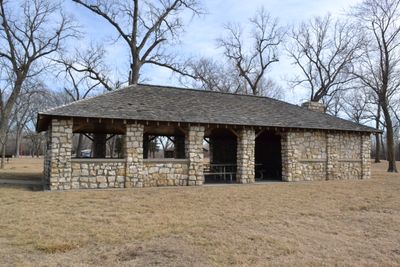
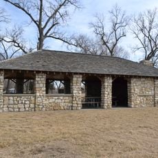
Lewis and Clark State Park stretches across about 189 acres along the southern shore of Lewis and Clark Lake. The grounds feature natural woodland, a stone shelter, and designated areas for camping and fishing.

The park was established in 1934 through donations from local sportsmen and was originally called Sugar Lake State Park. It was renamed in 1938 to honor the two explorers.

The stone shelter reflects craftsmanship from the 1930s and remains a focal point for gatherings throughout the park. Visitors often stop here to appreciate the masonry work while enjoying the lakeside setting.

The park is easy to navigate on foot and offers accessible areas for different activities throughout the grounds. Recent improvements to facilities make visiting comfortable for most people.

The lake inside the park received its original name from William Clark after he spotted large flocks of geese and goslings during early travels. This observation shaped how the water body was first identified by explorers.

The community of curious travelers

AroundUs brings together thousands of curated places, local tips, and hidden gems, enriched daily by 60,000 contributors worldwide.

Start exploring
Location
Inception
1934
GPS coordinates
39.53810,-95.05750
Latest update
December 13, 2025 12:41
Around this place
Amelia Earhart Birthplace
United States of America

Amelia Earhart Birthplace

5.7 km
Amelia Earhart Bridge
United States of America

Amelia Earhart Bridge

5.3 km
McInteer Villa
United States of America

McInteer Villa

7.1 km
Larry Wilcox Stadium
United States of America

Larry Wilcox Stadium

6.4 km
St. Patrick's Catholic Church
United States of America

St. Patrick's Catholic Church

9.4 km
Ebenezer Baptist Church
United States of America

Ebenezer Baptist Church

6.7 km
Weston Historic District
United States of America

Weston Historic District

19.3 km
Trinity Episcopal Church
United States of America

Trinity Episcopal Church

5.7 km
Pleasant Ridge United Baptist Church
United States of America

Pleasant Ridge United Baptist Church

21 km
J. P. Brown House
United States of America

J. P. Brown House

6.3 km
W. W. Hetherington House
United States of America

W. W. Hetherington House

6 km
Atchison County Courthouse
United States of America

Atchison County Courthouse

6.2 km
Jansen House
United States of America

Jansen House

6.1 km
Frank Howard House
United States of America

Frank Howard House

5.7 km
Glick–Orr House
United States of America

Glick–Orr House

5.7 km
Robert L. Pease House
United States of America

Robert L. Pease House

5.7 km
A. J. Harwi House
United States of America

A. J. Harwi House

6.9 km
B. P. Waggener House
United States of America

B. P. Waggener House

6.3 km
Francis and Harriet Baker House
United States of America

Francis and Harriet Baker House

6.4 km
Frederick W. Stein House
United States of America

Frederick W. Stein House

5.8 km
Price Villa
United States of America

Price Villa

6 km
Edgar W. Howe House
United States of America

Edgar W. Howe House

6.5 km
Balie P. Waggener House
United States of America

Balie P. Waggener House

6.4 km
H. E. Muchnic House
United States of America

H. E. Muchnic House

6.1 km
Amelia Earhart Hangar Museum
United States of America

Amelia Earhart Hangar Museum

10.9 km
Sugar Lake State Park Open Shelter
United States of America

Sugar Lake State Park Open Shelter

223 m
Amelia Earhart Historic District
United States of America

Amelia Earhart Historic District

5.9 km
Amelia Earhart Bridge
United States of America

Amelia Earhart Bridge

5.3 km
Show the full map
Reviews
Share your experience

No review yet

Discussions
Start a discussion...

No discussion yet

« Lewis and Clark State Park - State park in Buchanan County, United States » is provided by Around Us (aroundus.com). Images and texts are derived from Wikimedia project under a Creative Commons license. You are allowed to copy, distribute, and modify copies of this page, under the conditions set by the license, as long as this note is clearly visible.

Discover hidden gems everywhere you go!

From secret cafés to breathtaking viewpoints, skip the crowded tourist spots and find places that match your style. Our app makes it easy with voice search, smart filtering, route optimization, and insider tips from travelers worldwide. Download now for the complete mobile experience.

Around Us App Screenshot

A unique approach to discovering new places

Le Figaro

All the places worth exploring

France Info

A tailor-made excursion in just a few clicks

20 Minutes

Around Us
Travel Guide & Maps
Download

Send to your phone

QR Code
1

Open the camera app on your mobile.

2

Point at the QR code with your camera. A notification will appear.

3

Tap the notification to open the link.