Amelia Earhart Bridge

Log in to your account

AroundUs is a community-driven map of interesting places, built by curious explorers like you. It grows with every review, story, and photo you share.
Connect to save your favorite spots, contribute locations, and create personalized routes.
Continue with Google
Continue with Apple
Continue with X
Continue with Facebook
Continue with email
By continuing, you accept our Terms and Conditions and our Privacy Policy
Create an account

Amelia Earhart Bridge

Add to collection
Map
Suggest a change
Share

Amelia Earhart Bridge, Steel road bridge in Atchison County, United States.

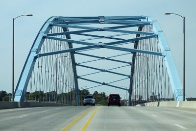
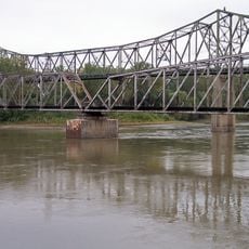
Amelia Earhart Bridge is a steel bridge that crosses the Missouri River and connects Atchison County, Kansas to Buchanan County, Missouri. The structure uses a tied arch design to carry four lanes of traffic on U.S. Route 59 and features LED lighting for night travel.

An earlier bridge built in 1938 served the region during the New Deal period before being replaced in December 2012 with a new structure. The replacement was designed to meet modern traffic demands and improve the crossing between the two states.

The bridge honors Atchison's native aviator Amelia Earhart, whose pioneering spirit shaped the town's identity. This naming reflects how the community keeps her legacy visible in everyday spaces where residents cross daily.

The bridge is open to traffic year-round and regularly maintained for safe conditions. Visitors should be aware that winter weather and river flooding can occasionally affect passage, so it is best to check local conditions before crossing during storms or high-water periods.

Construction faced delays when the Missouri River flooded in 2011, requiring engineers to develop special adaptations for assembling the arch structure on site. This flood-related challenge became part of the bridge's engineering story and influenced how the final structure was built.

Location: Atchison County

Location: Buchanan County

Inception: December 2012

Official opening: December 2012

Made from material: steel

GPS coordinates: 39.55939,-95.11324

Latest update: December 12, 2025 17:49

Photos
Around this place
Amelia Earhart Birthplace
United States of America

Amelia Earhart Birthplace

481 m
McInteer Villa
United States of America

McInteer Villa

1.8 km
Lewis and Clark State Park
United States of America

Lewis and Clark State Park

5.3 km
Larry Wilcox Stadium
United States of America

Larry Wilcox Stadium

2 km
Doniphan County Courthouse Square Historic District
United States of America

Doniphan County Courthouse Square Historic District

25.3 km
St. Patrick's Catholic Church
United States of America

St. Patrick's Catholic Church

10 km
Ebenezer Baptist Church
United States of America

Ebenezer Baptist Church

1.5 km
Weston Historic District
United States of America

Weston Historic District

24.4 km
Trinity Episcopal Church
United States of America

Trinity Episcopal Church

438 m
J. P. Brown House
United States of America

J. P. Brown House

1.2 km
W. W. Hetherington House
United States of America

W. W. Hetherington House

675 m
Atchison County Courthouse
United States of America

Atchison County Courthouse

915 m
Jansen House
United States of America

Jansen House

1.2 km
Frank Howard House
United States of America

Frank Howard House

542 m
Glick–Orr House
United States of America

Glick–Orr House

416 m
Robert L. Pease House
United States of America

Robert L. Pease House

444 m
A. J. Harwi House
United States of America

A. J. Harwi House

1.5 km
B. P. Waggener House
United States of America

B. P. Waggener House

1.3 km
Francis and Harriet Baker House
United States of America

Francis and Harriet Baker House

1.3 km
Frederick W. Stein House
United States of America

Frederick W. Stein House

608 m
Price Villa
United States of America

Price Villa

1.2 km
Edgar W. Howe House
United States of America

Edgar W. Howe House

1.7 km
Balie P. Waggener House
United States of America

Balie P. Waggener House

1.4 km
H. E. Muchnic House
United States of America

H. E. Muchnic House

1.1 km
Amelia Earhart Hangar Museum
United States of America

Amelia Earhart Hangar Museum

5.7 km
Sugar Lake State Park Open Shelter
United States of America

Sugar Lake State Park Open Shelter

5.1 km
Amelia Earhart Historic District
United States of America

Amelia Earhart Historic District

973 m
Amelia Earhart Bridge
United States of America

Amelia Earhart Bridge

45 m
Show the full map
Reviews

Visited this place? Tap the stars to rate it and share your experience / photos with the community! Try now! You can cancel it anytime.

« Amelia Earhart Bridge - Steel road bridge in Atchison County, United States » is provided by Around Us (aroundus.com). Images and texts are derived from Wikimedia project under a Creative Commons license. You are allowed to copy, distribute, and modify copies of this page, under the conditions set by the license, as long as this note is clearly visible.

Discover hidden gems everywhere you go!

From secret cafés to breathtaking viewpoints, skip the crowded tourist spots and find places that match your style. Our app makes it easy with voice search, smart filtering, route optimization, and insider tips from travelers worldwide. Download now for the complete mobile experience.

Around Us App Screenshot

A unique approach to discovering new places

Le Figaro

All the places worth exploring

France Info

A tailor-made excursion in just a few clicks

20 Minutes